Overview
‘East Opoca’ (GR 376159), or 'Elpoca Creek Hill', is a small, unassuming bump along the western edge of the
Opal Range. This low elevation summit reaches about 2450 metres (8,040 feet) is not officially named. This appealing hill is frequented by hikers seeking to enjoy the grand view of the Opal Range and Kananaskis Lakes area. Along the western edge of the Opal Range, above Pocaterra Creek and Kananaskis River, there is a nearly continuous ridge line, broken by a few perpendicular deep cut creeks. These deep creeks isolate several named highpoints (
Gap Mountain,
Mount Wintour,
King Creek Ridge and
'Grizzly Peak' (GR328249)), but one impressive feature,
'Opoca Peak' (GR 368155), sees little attention and lacks an official name or local name. GR denotes Universal Transverse Mercator (UTM) National Topographic System of Canada (NTS) grid reference.
![Opoca Peak and East Opoca]() 'Opoca Peak' (l) and 'East Opoca' (r)
'Opoca Peak' (l) and 'East Opoca' (r)
I applied the name of 'Opoca Peak' since this highpoint divides the drainage between Opal and Elpoca Creeks. Just east of 'Opoca Peak' is the diminutive, but attractive mound of East Opoca. The col between 'Opoca Peak' and 'East Opoca' provides approximately 120 metres of prominence to the summit of 'Opoca Peak' and about 90 metres of prominence to the east highpoint; there is about 1 kilometre of isolation between these highpoints. 'East Opoca' has two summits, with the western highpoint being slightly higher. No official record of a first ascent, but likely this hill would have been easily ascended many years ago.
Getting There
Best vehicle access from Canmore/Banff or Calgary is via the Trans Canada Highway, then south along Highway 40. From the intersection of Highway 40 (Kananaskis Trail) and Highway 1 (Trans Canada Highway) travel south towards Kananaskis Lakes. From the 1 / 40 intersection travel south 54.5 km to the Valleyview road turnoff.
A portion of Highway 40 is closed for wildlife protection during the winter/spring. From December 1 to June 15 Highway 40 is closed from the Kananaskis Lake turnoff to the intersection of Highway 940, near the Highwood River. This closure is about 5 km north of the Valleyview road trail head. A bike or ski approach can make short work of this distance.
Red Tape / Camping and Bivouacs
Peter Lougheed Provincial Park is a popular and busy recreation area hectic with front country users in the summer months. Off the beaten track areas, like Opal Creek, are easy to find and often very wild, usually providing a solitary experience.
A fee is now required (2021) to enter, park or hike in Peter Lougheed Provincial Park. A hike up and down East Opoca is easily done in a day and does not require a bivy. Within Peter Lougheed Provincial Park, backcountry camping, including bivouacs for climbing, are only allowed in designated campsites. There are no backcountry campgrounds in Opal, King or Elpoca Creeks.
Important Red Tape Update. As of June 2021, a mandatory user fee will be in place for Kananaskis Country - 90$ for an annual pass or 15$ for a day pass. Up to date information about Peter Lougheed Provincial Park available at:
Peter Lougheed Provincial Park
Approach
Opal Creek intersects the old Valleyview road just above Highway 40. The Valleyview road was recently closed to vehicle traffic to protect Grizzly Bear habitat. This old paved road is gated about 200 metres after leaving the main highway, park alongside the old road. Hike pass the gate, approaching the Opal Creek bridge.
![Road Closed]() gated road
gated road | ![Start of trail]() start of trail
start of trail | ![Descending north bank above Opal Creek]() high north bank trail
high north bank trail |
Just before the bridge, turn left, north, onto the north bank of Opal Creek. Just off the pavement, the trail follows the north bank a very short distance (10 metres or so) then the trail climbs steeply out of the creek and heads north, just above the creek. After a short distance in the trees, the trail rises along the steep north bank of Opal Creek. Follow this obvious and well worn trail up to the scree slopes below the cliff band that forms Opal Falls. The obvious trail continues in the scree, heading north, below the cliff band for about 400 metres to the base of wide and loose gully that breaks the cliff band. Bash up loose dirt and rock into the narrowing gully, as you near trees on the right, head towards them for more solid ground. Once above the rocky rib on your right, work your way up low angle rock and scree into the trees above. An excellent, well worn trail begins above in the trees, first on the narrow crest of a rocky rib. This excellent trail heads up Opal Creek on the north bank.
![Traverse below band]() traverse below band
traverse below band | ![Looking up access gully]() view up access gully
view up access gully | ![Great trail leads to Opal Creek]() above access gully
above access gully |
When to Hike
Typical Canadian Rockies situation; best conditions for a high elevation scramble route or hike is July to early September. The low elevation and ease of the hike allows hiking by mid June and into the late fall, depending on the year, this peak could be hiked into November.
Route Description
The ease of the terrain provides many options for approaching, ascending and descending East Opoca. The most direct approach from Opal Creek provides easy access to the low angled treed slopes of north side of East Opoca. There is one recent published source for information on 'East Opoca', Gillian Daffern’s
Kananaskis Country Trail Guide.
North Slope, West Ridge Scramble
From the col between Opoca Peak and East Opoca, several avalanches paths drop to Opal Creek. We used the second one on the right, south, to access the col, closer to Opoca Peak. This gully was mostly clear of trees and was an easy plod up. Several other avalanches paths exist, but most are more heavily treed.
![Bottom of avi path]() bottom of avi path
bottom of avi path | ![Half way up to col]() view down avi path
view down avi path | ![Nearing Opoca Peak]() nearing col, Opoca Peak
nearing col, Opoca Peak |
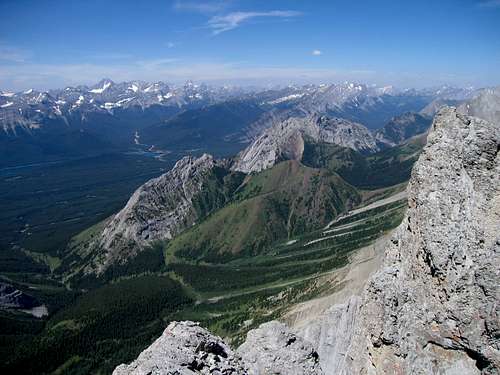
Once along this long col, it is an easy hike to the summit of East Opoca. From the low point, the trees thin out as one hikes to the western highpoint. The eastern pinnacle of East Opoca is a short hike from the summit and provides a slightly different view of the area. Both highpoints provide excellent views of the Opal Range and Kananaskis Lakes region. Several options exist for extending the hike with traverses or descents into either King or Elpoca Creeks. Return the same way or explore this beautiful valley by connecting into other creeks.
![East Opoca, eastern highpoint]() summit shot
summit shot | ![Rainy summit]() Raff on summit
Raff on summit | ![Lower eastern highpoint of East Opoca]() view to east summit
view to east summit |
![Rainy and cloudy summit]() Raff on east highpoint
Raff on east highpoint | ![View from lower summit]() west view to Opoca Peaks
west view to Opoca Peaks | ![Mt. Wintour to north]() view to King Creek divide
view to King Creek divide |

 3436 Hits
 76.66% Score
 7 Votes
 'Opoca Peak' (l) and 'East Opoca' (r)
 gated road
 start of trail
 high north bank trail
 traverse below band
 view up access gully
 above access gully
 bottom of avi path
 view down avi path
 nearing col, Opoca Peak
 summit shot
 Raff on summit
 view to east summit
 Raff on east highpoint
 west view to Opoca Peaks
 view to King Creek divide