
-
 8327 Hits
-
 87.31% Score
-
 24 Votes
|
|
Mountain/Rock |
|---|---|
|
|
46.59892°N / 13.18471°E |
|
|
Hiking, Scrambling, Skiing |
|
|
Spring, Summer, Fall, Winter |
|
|
7172 ft / 2186 m |
|
|
Overview
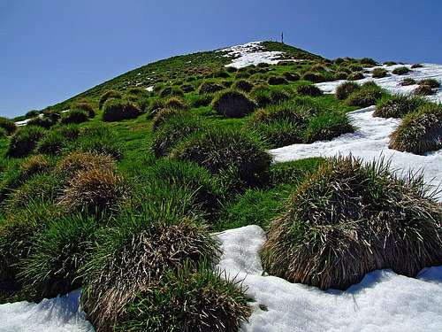
Below the summit

From the south (from Zermula)

Hochwipfel and Schulter from the SW

The NW face

From the south
Summits, described here
> Hochwipfel, 2195 m,
> Schulter (Schulterkofel) / Creta di Lanza, 2057 m,
> Windschaufel, 2095 m,
> Kirchbacher Wipfel, 1880 m.
The summits in the ridge south od Schulterkofel are described on the page of Ringmauer / Pale di San Lorenzo.
General
Going in a west-east direction, after Hoher Trieb / Cuestalta the main crest of Eastern Carnic Alps lowers considerably. Till Trogkofel / Creta di Aip mountains are not so much rocky, but grassy to their tops, even if some elevations exceed 2000 meters. And indeed, even if today Passo di Meledis, 1578 m, is not important, archeological findings prove that in ancient times it was a much more used connection between Paularo cauldron and Gail / Zilja valley.
From the main range towards the north, down to Gail / Zilja valley long side ridges deter, almost all of them rounded and grassy, appropriate for easy hikes and skiing. In one such side ridge also Hochwipfel rises. But on the main crest there are no higher summits in that area, the highest one is the big grassy Hochwipfel pyramid, where three grassy and partly rocky ridges culminate. Having no high neighbours close-by, Hochwipfel offers in a nice day a very broad panorama, which is just a little obscured towards the east with the mighty Trogkofel / Creta di Aip.

Hochwipfel is first of all a hiking mountain. Along the whole Carnic Main Crest goes the famous Karnischer Hoehenweg / Traversata Carnica - a multi-day, long-distance hike. I remember to read that Hochwipfel is also a very nice mountain for tour skiing, but when after the ascent I looked in my guidebook, it is there not mentioned at all. Very strange, because the slopes of Hochwipfel, although quite steep, are certainly appropriate for skiing. The area around Hochwipfel is also very appropriate for mountain biking. Many mountain roads and good paths, originating from ex military roads can bring you quite high, the total elevation gain from the valley of Gail / Zilja could exceed 1200 meters. And the last, but not least matter of interest - the area is well known by producing good cheese - the Gailtaler Almkaese ('Gail valley alpine cheese').
Other peaks
Close to the highest summit there are some more peaks to mention. South-west of the main summit, already on the main Carnic crest and so on the Austrian-Italian border, there is the rocky summit of Schulter / Creta di Lanza, 2057 m. It shows a picturesque, 150 meters high rocky wall towards the west, towards the east also Schulter is grassy. Towards the SE of Schulter there are some more rocky bumps in the main crest, less important for mountaineering. And towards the north and the east Hochwipfel is sending another two grassy ridges, culminating in two grassy summits, which are still above the timber line: Kirchbacher Wipfel, 1880 m, in the N-NW ridge, and Windschaufel, 2095 m, in the NE ridge.
Geology

Hochwipfel is famous in geology due to the rock formation it is built of. It is even named the Hochwipfel Formation. There are various (four main) types of it, but generally those are grey/brown slates and sandstones from early Carboniferous era. Not only is Hochwipfel built of those rocks (there the layers are almost 1000 m thick), but they are found also in many other regions of Carnic Alps and and even in Karawanks, further towards the east. In the area of Hochwipfel also older rocks can be seen, such as the black slates of Silurian.
Schulter, the SW neighbour od Hochwipfel, is however built of much lighter, late Carboniferous and early Permian limestones. On the picture, showing both mountains from the west, it can be clearly seen how different are the dark, grassy slopes of Hochwipfel and the light grey rocky face of Schulter.
Summit Panorama
 Towards Trogkofel Towards Trogkofel |
 Towards the west Towards the west |
Getting There
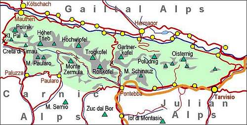
Carnic Alps - Main Ridge (Eastern part)
For general overview, see the Carnic Alps group page and the Carnic Alps Main Ridge (East) subgroup page.
Gail / Zilja valley on the north can be reached from Villach (highway), driving towards the west. Paularo can be reached from Tolmezzo (highway), driving towards the north and then deterring north-east in Val Incarojo. Pontebba lies by the Udine-Villach highway.
Hochwipfel summit can be reached from three main directions (mountain roads on the northern side offer some more possibilities):
1. From Straniger Alm, 1492 m. The meadow can be reached by a narrow, but still solid mountain road, starting in Stranig in Gail / Zilja valley. It is opened for public traffic from June 1st till end of September. From Straniger Alm the mountain road continues to Klein Kordin Alm, 1624 m. I nowhere saw any signs prohibiting the drive, but it is a bit untasty to use noisy vehicles so high on nice mountains. This is the western approach.
2. The second approach from the Gail / Zilja valley brings you on Hochwipfel's eastern slopes. The publicly open mountain road starts in Rattendorf and brings you up on Rattendorfer Alm, 1531 m, where you find a free parking place.
2a. For the tour over the N-NW ridge (Kirchbacher Wipfel) the trailhead is in Oberdobernitzen, 619 m, by the bridge over Gail / Zilja.
2b. For the summer tour over the NE ridge (via Riegel Alm), I guess you need to park on the crossroads 960 m.
3. The third approach comes from the south, from Passo del Cason di Lanza, 1552 m, which is reachable by a nice mountain road, which encircles Monte Zermula, thus connecting the towns of Pontebba and Paularo. The road is usually opened from end of April till end of October.
 Straniger Alm Straniger Alm |
 Klein Kordin Alm Klein Kordin Alm |
Routes Overview
The summit of Hochwipfel can be reached also over a pathless terrain, but the majority of visitors ascend it by the two marked approaches.
1. From the S and SW
By Karnischer Hoehenweg / Traversata Carnica you reach the small saddle south of Schulter, cca 1964 m. From there go towards the north on the notch between Schulter and Hochwipfel. On this crossing, the trail goes only some 50 m below the summit of Schulterkofel, which is easily reachable. From the notch between Schulterkofel and Hochwipfel we continue either over the SE slopes of the latter or by its SW ridge to the top. It's an easy hike (the SW ridge is steep and requires quite some attention), but still on steep grassy slopes attention is needed, especially in wet conditions. On the Swiss Hiking Scale the ascent difficulty would be graded T3. In winter ice pick is useful and the full equipment only if snow is very hard or icy. From Straniger Alm, 1492 m, 2 hours 15 minutes, from Klein Kordin Alm, 1624 m, 1 hour 45 minutes, from Rattendorfer Alm, 1531 m, 2 hours, from Passo del Cason di Lanza, 1552 m, 2 h 30 min.
A tip for descent: From the notch between Schulter and Hochwipfel there goes a nice ravine down towards Klein Kordin Alm. In May 2007 it was still quite filled with snow, so I descended there, even if there's no path. Below, where the ravine gets steep and rocky, you need to exit it towards the right and then you descend further by nice meadows.
 Over the S slopes Over the S slopes |
 On the notch On the notch |
 Direct W descent Direct W descent |
2. From Rattendorfer Alm
I guess this is the most poular ascent route for Hochwipfel. From the parking place below the alpine meadow, 1535 m, we continue in the W-SW direction by the trail No. 417. After some 20 minutes, near Zanklhütte, 1650 m, we reach the small Scotti chapel with cemetery from the World War I. Higher on, the trail detours rocky formations of Ringmauer on their northern side, and brings us on the state border on the saddle 1964 m, south of Schulter. Then as described above in tour #1 towards the north on Hochwipfel. 2 hours, difficulty T3.
You can see a detailed map (1:50.000) on-line on: http://www.austrianmap.at/.
3. Ski tour from Rattendorf

In winter the lower part of the road to Rattendorfer Alm is often arranged as a sledge piste. So, you must start the ascent on the lower parking place, follow the sledge piste to the crossroads (960 m) to Rattendorfer Alm and there turn right, towards Riegel Alm. After some 550 m you reach on open terrain and continue by the NE ridge to the summit of Hochwipfel. The whole tour is medium demanding, except the ascent on Lackenwipfel, which is quite steep. For 1700 m of altitude we need some 5 h for ascent only. It must be one of the most beautiful ski tours in the region, but also quite demanding.
4. By the N-NW ridge
This tour crosses the summit of Kirchbacher Wipfel, 1880 m. The road to Kirchbacher Wipfelalm (pasture), 1576 is closed for public traffic already below, in the village of Oberdobernitzen (south of Kirchbach). So we start the hike-up on 619 m and all the initial 900 m of altitude are by the road through dense woods. Later the marked trail is nice and panoramic. I guess in good snow conditions also this ridge tour can be done with skis.
Red Tape
There are no limitations. Some mountain roads which you can see on the maps are private and closed for public traffic.
Huts And Camping

Straniger Alm

Straniger Alm
On the surrounding alpine meadows there are many private huts, where you can eat and drink. The two bigger mountain huts, reachable by car, where you can also sleep are:
Straniger Alm, 1492 m. Managed by Sagmeister family, tel.: +43(4285)243. The hut has a few rooms, prices vary from 45€ to 75€.
Casera Cason di Lanza, 1552 m. It has 14 places and 6 places in winter room. Opened from start of May till end of October. Tel.: 042890928.
When To Climb?
Hochwipfel can be ascended any time of the year. Very beautiful is autumn, but also spring and seasons when conditions for ski touring are good.
Books

- R. Gaberscik: Guida escursionistica alle Alpi Carniche. Studio64srl Edizioni, 2010 (7th edition), Genova. In Italian.
- P. Holl: Karnischer Hauptkamm (Alpenvereinsfuehrer). Bergverlag R. Rother, Muenchen, 1988 (2nd edition). In German.
- Guidebook and photomonography (in Slovenian): V. Pogačnik: Kar na Karnijce. Založba Narava, 2011.
Farewell
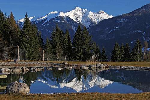 The view on Hochwipfel from the NW, from Wieserberg, across the valley of Gail/Zilja.