
|
|
Mountain/Rock |
|---|---|
|
|
33.3586°S / 69.77004°W |
|
|
Mountaineering |
|
|
21555 ft / 6570 m |
|
|
Overview
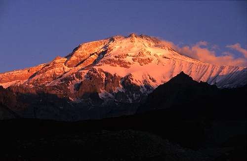
Tupungato seen from the Chilean side.
As Tupungato is one of the highest peaks of Andes and the access is realatively easy from Santiago, you would think it's a popular climbing target. It's not. Only a couple of dozens of people attempt the peak and one reason may be its higher neighbor, which draws climbers by the thousands every year.
It's an old strato volcano. It's the 14'th highest on the South American continent and the third highest in High Andes (Cordillera Central) after Aconcagua and Mercedario.
The summit was reached for the first time in 1897 by Swiss cimber and guide Mathias Zurbriggen. On the same journey Zurbriggen also made the first ascent of Aconcagua.
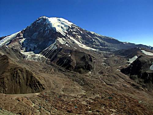
Peaks in the area and summit views.
It´s located in a very beautiful and unspoiled area and there are many other interesting peaks close by. Polleras, Negro/Pabellón, Chimbote, Tupungatito and Alto are the highest and most well known.
The views from the summit is stunning and apart from the above already mentioned you have great views of the peaks of Cordon del Plata, where Cerro Plata stands out being the highest. Further north, close to Aconcagua you can see Ameghino and La Mano. More distantly to the north you can see the impressive Mercedario Group, where Mercedario, Ramada and La Mesa are the most prominent.
Getting There
Attempting the peak from Argentina has one big problem: wild rivers. All the routes are quite long and one or more river crossings may stop the plan. During the South American summer it's sometimes completely impossible to reach the peak at all from Argentina. In the beginning of the off season (late March/early April) it's generally OK.
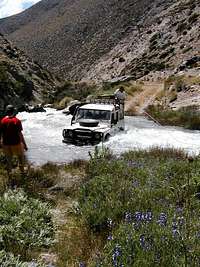
Crossing Rio Santa Clara
From Argentina - via Paso Santa Clara
The easiest route to the peak from Argentina. Start from the town Tupungato. You can either go parts of the way with a collectivo (share taxi), rent a vehicle or hitch. You must have a permit for the Santa Clara military zone before leaving for the mountain or you'll be turned back at the start of the Santa Clara river gorge. The military check point is located on the left hand side of the valley.
There's a vehicle track leading up the valley and terrain vehicles can travel it. The catch is the river crossings. At times it impossible to cross the river, even with mulas. If you manage to reach the end of the road the rest of the walk to Paso de Santa Clara is easy. Steep up, but the river problem is over. There are some alright camp spots below the last steep section leafing to the pass.
On the west side of the pass it's at first gradual downhill in an open valley. The last part down to the Rio Tupungato valley is in a very narrow, rocky and steep canyon. This section is prone to lots of rockfalls and I wouldn't travel it when rainy/wet.
Arrival in Rio Tupungato valley. Cross Rio Tupungato and head up the main valley leading west. In the beginning it's obvious which valley to follow, but later on be sure you don't end in any of the more northern valley. The main and most open valley is the correct one leading to the Tupungato Pass, which is the where the long ridge leading to the peak starts. This is also the border of Chile and where you join the standard/Chilean route.
Tupungato from Fraile Pass
From Argentina - via Paso del Fraile
Probably the second most difficult way to the peak. If the water levels in Rio de las Tunas are high, your chances of reaching the pass leading to the Tupungato valley are low. You can always trek high on the mountain sides, not crossing the river, but this is only for the desperate. The Fraile Pass is easy on the eastern side, but very steep on the west. You have to make your way down on loose scree and rockfalls is a problem. If you slip and fall there's a very high risk for bad injuries.
When you have made it down from the pass a day on the moraines of Tupungato is waiting. A bit tricky in the beginning, but the valley opens up later on and the last last part of the walk to the foot of Paso Santa Clara is easy. From there on the route is the same as for the Santa Clara route.
From Argentina - from Punta de Vacas
This option is a bit of a go or no go. If the water levels in Rio Tupungato is low it's a great option, if not you wont reach the peak. The river is huge and many times not possible to cross, even with the support of mulas. Ask about the conditions in Punta de Vacas, from where the trek starts. If you manage to cross the river, the rest of the walk to the foot of Paso Santa Clara is easy and from there on you follow the route described as Santa Clara route above.
From Argentina - from Tunyuan
If you want to climb from the south, i.e. not the normal route, this is the best option. You start from the town of Tunyuan. From there rides can be arranged to Paso El Portillo. If early in the season, the vehicle may not reach the pass due to snow and/or penitentes. Walk down the main valley and cross a river on your right. This crossing may be impossible when the water levels are high. If you manage the large Rio Tunyuan is waiting. The place to cross is at Refugio Real de la Cruz. Also this crossing can be very difficult. From there you make your way north to the peak's foot. Tricky in parts, from what I could see, but I can't give you details as I didn't manage to cross Rio Tunyuan.
From Chile
An overwhelming majority use this option, even if it involves some permit hunting before you can take off.
The former maintainer's info - Access from Chile
Arriving in Santiago, and after taking all permits, you must find a way to get where the trail starts.
The Club Andino Aleman of Santiago charges about US$ 100,00 to leave the people there. But there is a way to go and save money.
When I went to Tupungato at 2003 Febbruary, I took a bus in Santiago to San Jose de Maipu, and I asked to the driver to stop at the cross betwen the mainly road and the road that leaves to Alfafal. We dropped there, in the middle of nothing and started to asked at the houses around for someone who have a car to leave us where the trekking start. We paid about 20.000 pesos, that is about 25 bucks!
Alfafal is a power plant that is administrated by Gener. There you must show your permits to enter.
You 'll also pass at a military area, so, you have take that permits. There is more 30 Km of a unpaved road to get there.
That road is for a mining company exclusive use, so you'll not find civilian cars. Only Trucks! But with the permits, your hike could go.
THE APPROXIMATION:
Day 1:Arriving where the trail starts, just 15 minutes up hill you find a good place to camp, Chacayes. You are at the beggining of begging.
Day 2: Following the trail, you'll walk up thru the Colorado river valley. A 5 or 6 hour of trekk you'll arrive at tributary river of Colorado, the Museo river, where has a good place to camp, Baños Azules, close to a small peak called "Pan de Azucar".
Day 3: That day is the worst one. You shoud cross the Estero del Museo river, go up to the Pan de Azucar slopes get do get down to another river, Estero del Azufre, that is situated inside a big canyon. Getting up all again you'll also walk more about 6 hour, still get at the Tupungato termas, a natural hot water pool. Walking a little more, you'll find close to the Estero del Tupungato River a good place to camp, that is the first place you can see to Summit of Tupungato and Tupungatito. That place is called Piedra azul, at 3000 meters high.
Day 4: Following the trail, you'll cross more two deep canyons rivers, and finally arrive at Vega de los Flojos, no more than 3200 meters. It takes less than 2 hour to do it. Take that day to rest.
Day 5: From Vega de los Flojos cross a hughe frontal moraine, walking up two valleys. Walk always on the right. It will have a moment that you'll have to go up the right side of a slopes, take care, that place is dificult to find the trail, crossing the rivers will show a great problem in that mountain.
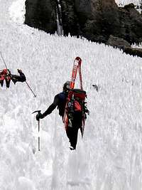
Going up that slope, I'll cross a camp place called Los Espanholes. That is not a good place to rest because of the water, so continue following the trail, still arrive at a "paso" where you 'll find a beautifull ice towers formation called "penitentes", where has a good place to camp at 4300 meters.
Day 6: Go up to a camp situated at 5200. You'll cross a camp place at 4600 and some penitentes formation.
Day 7: Do up to 5500 camp. It's not a long trip, so you can choose to camp more high, about 5800.
Day 9: Summit Day.
For go back you leave about 3 or 4 days!
Red tape
From Chile
Three permits are required:
From Chilean army, DIFROL and GENER
All permits are free of charge and can be arranged in Santiago.
Start with the DIFROL permit as you may not get the GENER permit if you don't have it. The latter can be arranged by mailing GENER. DIFROL gives you the permit when you have filled in their online questionaire.
The army permit may not be necessary, but a good advice is to get it to be sure of a friction free passage to the peak.
The first permit you must take is from DIFROL, that is the governamental department that takes care the boundaries (Dirección de fronteras y limites). You take that permit at that address:
Calle Bandera 52, 4th floor.
telephone: 56-2-6714110
fax: 56-2-6711909
Arriving there, you must leave a letter with your personal information. Than they will gave you another letter, to leave to the Chilean Army.
The army will gave you other letter that you'll have to send to GENER.
With the GENER letter in hands, you'll can go!
internet:
http://www.difrol.cl/index3.htm
email: difrol2@minrel.cl
From Argentina
Entering from Punta de Vacas - no red tape.
Entering from Tupungato town - you must have a permit from the army in order to pass the Refugio Militario Plaza, in the beginning of the Santa Clara river valley. If you don't have it you'll be stopped and sent back. The only way to avoid this is to ask a land owner in the area for permission to pass over his/her land. The catch with this plan is that you then have to walk over yet another range to reach the Rio de las Tunas river valley. The army permit is free of charge and can easily be arranged in a short time in Tupungato village.
Entering from Tunyuan - no pre arranged permit needed, but there's a military checkpoint on the way to the mountains. The officer in charge will ask you to write down your details and may also ask you some questions about how long you plan to be in the mountains and which route you plan to use. I was further asked how much food I had and if I had equipment enough.
When To Climb
The best season to climb is during the South American summer - December to February.
The fall season has some advantage in terms of access as the water levels in the rivers are lower than in the summer of spring seasons. The winter is very cold and windy. Full winter expedition gear is an absolute must.
Camping
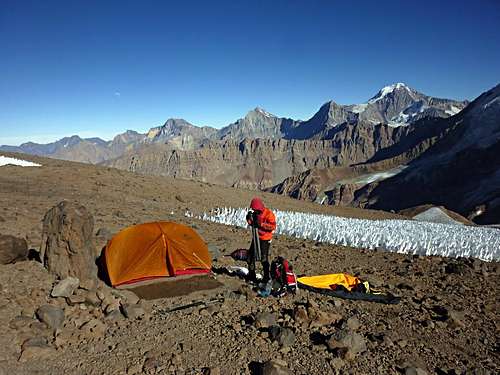
Camp at 4800m close to the Tupungato pass, which also is the border (Arg./Chi.)
Camping is allowed in the area and there´s no alternative. The only places you aren´t allowed to camp is in the areas private land on the walk in.
The winds in the area can be violent, so make sure you pitch your tent carefully.
Mountain Conditions
See http://www.meteochile.cl/Pronos/pron_gral.html and click on Cordillera-zona central for weather conditions on the mountains of Central Chile.
Miscellaneous Info
To see more information, At Santiago look for The Club Andino Alemán...
Club andino's site:(http://www2.ing.puc.cl/~cseebach/Climbing/dav/)
To buy maps of Tupungato and all Chile Mountains:
IGM - Instituto Geografico Militar: Calle Dieciocho 369, Toesca subway station - Santiago.
www.igm.cl
External Links
- gentedemontanha.com
more photos about Tupungato - difrol
Chilean department of boundaries, link for permits information - Instituto Militar Geográfico
Maps of Chile - Club Andino Aleman
Club Andino Alemán of Santiago de Chile.
Guides and information about the mountain - meteochile
Weather conditions in Chile - tutiempo.net
Weather conditions of Argentina
Climbpeaks - Jul 19, 2005 6:03 pm - Hasn't voted
Untitled Commentcrashed somewhere in the Andes while on approach to Santiago. The remains
of the plane were not found until 1998 on Tupungato by climbers.
More information about the mystery can be found here.
dsmith814 - Feb 23, 2016 11:56 am - Hasn't voted
Tupungato 2016The IGM Tupungato topo map of the area is showing an elevation of 6570 meters for the South Summit elevation. My Garmin GPS indicated an elevation of 6574 meters, so I would tend to think the map is pretty close with a correct elevation.