
-
 8643 Hits
-
 84.82% Score
-
 19 Votes
|
|
Mountain/Rock |
|---|---|
|
|
45.83626°N / 10.81530°E |
|
|
Trentino |
|
|
Hiking |
|
|
Spring, Summer, Fall, Winter |
|
|
2979 ft / 908 m |
|
|
Overview
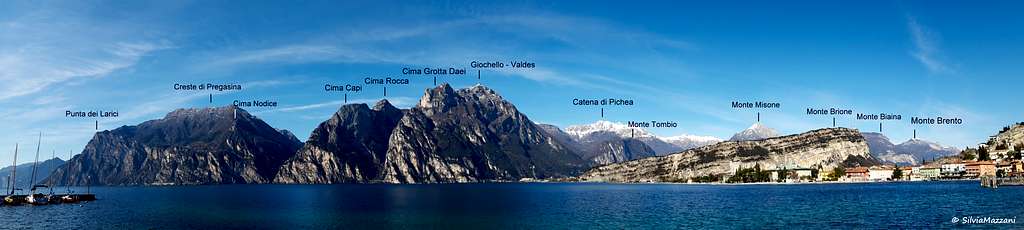
Punta dei Larici m 908
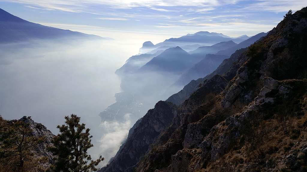
Punta dei Larici 908 m is rocky outcrop overlooking the Garda lake and belonging to the Prealpi Bresciane e Gardesane, located nearby the hamlet of Pregasina. The Northern end of the Western shore of the Garda lake is formed by a high and impressive rocky bastion of limestone, made of walls, cliffs and rocky towers interspersed with steep and narrow debris gullies, overlooking the water mirror.
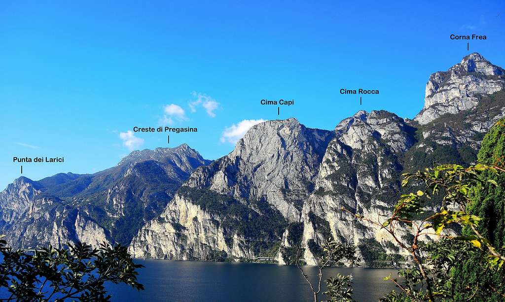
Just North to Limone, near the top of Punta dei Larici, it passes the border between Lombardy and Trentino. From the top, reachable with a panoramic itinerary, you can admire one of the most beautiful views of the area.
The Northern end of the Western shore of the Garda lake is formed by a high and impressive rocky bastion of limestone, made of walls, cliffs and rocky towers interspersed with steep and narrow debris gullies, overlooking the water mirror. Just North to Limone, near the top of the Punta dei Larici, it passes the border between Lombardy and Trentino.
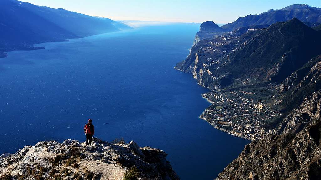
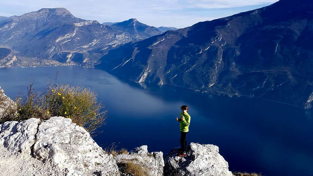
It's an extraordinary viewpoint and a very prominent position above the lake. From the summit the slope descends overhanging on the underwater, consequently the view is unforgettable, perhaps the best of the entire hike. The view sweeps northwards, at the mouth of the Sarca Valley with the town of Riva del Garda, Torbole and Arco. Facing eastwards, on the opposite side of the lake, there is the extensive chain of Monte Baldo, while to the south, the eye can wander along the lake surface towards the Southern edge.
Getting There
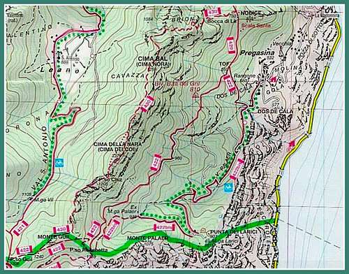
Access: from the Brennero autoroute exit Rovereto Sud and take the road to Arco and Riva del Garda. From Riva del Garda follow the road to Val di Ledro, which is reached through two long tunnels. A few hunderd meters after the exit of the second gallery, you will find on the left the narrow but paved road leading to the village of Pregasina 532 m. Leave the car in the small parking lot below the church.

|

|
Punta dei Larici Normal Route description
Punta dei Larici Normal route from Pregasina
Summit quote: 908 m
Difficulty: E
Difference in level: 376 m from Pregasina
Exposition: North
Time required: 1,45 hours round trip
Starting point: Pregasina m 532
From the parking lot in Pregasina you will find the staircase leading to the church of St. George located on the street above. From the curch take to the left the trail towards Passo Larici, Malga Palaer and Passo Rocchetta (path n. 422B). The path soon starts inside the vegetation and after few minutes it reachs a crossroad. Ignore the concrete road on the right and proceed straightly, following the road entering the Val Palaer (mark 422 bis).
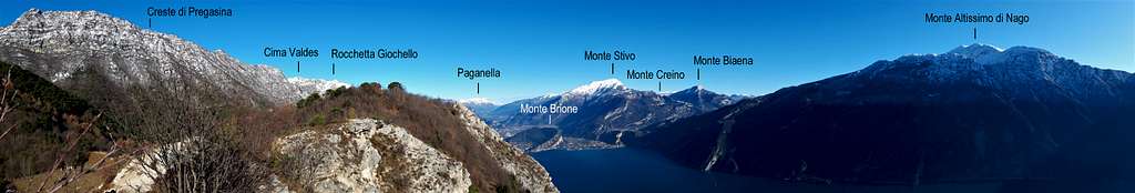
In the first stretch we can enjoy a superb view of Lago di Garda and the prospecting Monte Altissimo of Nago, then the trail enters the woodland with moderate slope and concrete sections. Continue in the forest with the possibility of avoiding some road-bends thanks to short breezes of footpath on a moderate slope. Lastly, we keep the gravel road reaching a crossroad towards Malga Palaer, heading to the right. We ignore it and heading left we can reach the wide saddle of Passo Larici m 881 (1 hour from the start). Here it appears a superb view of Lago di Garda.

|

|

|

|

|

|
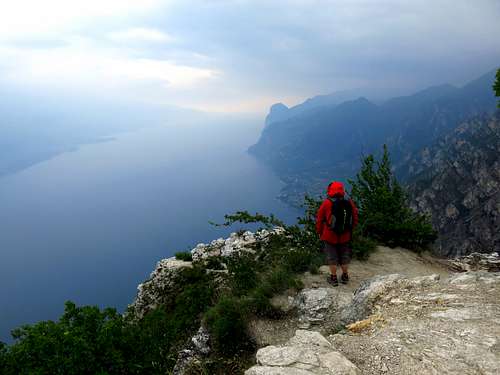
The place-name "larici" - meaning “larches” is due to the presence of several big larch trees. From the saddle we leave the mule track to turn left towards the very near Malga Larici and then climb in a few minutes without difficulties the summit of Punta Larici m 908, a very prominent elevation above the Lago di Garda, overhanging more than a hundred meters above the large water mirror. Obviously the view is impressive and unforgettable, but pay attention to the exposure!
Punta dei Larici across the ridges
Punta dei Larici across the Ridge Trail
Summit quote: 908 m
Difficulty: EE
Difference in level: 400 m from Pregasina
Exposition: North
Time required: 2,15 hours round trip
Starting point: Pregasina m 522

|

|
The starting point and the first stretch of this route are the same of the previous itinerary. Also this route in fact starts from Pregasina and it's an important variant of the main one branching off hat departs from it in the locality "Calcherola". From the Church of St. George in Pregasina take to the left the track towards Passo Larici, Malga Palaer and Passo Rocchetta (path n. 422B). The path soon enters inside the vegetation and after few minutes it reachs a crossroad. Ignore the concrete road on the right and proceed straightly, following the road entering the Val Palaer (mark 422 bis). After about 30 minutes you reach the "Calcherola" site at 655 m, where it begins on the left the 422A Ridges-trail, a highly panoramic path overlooking the Lago di Garda and leading directly to Punta dei Larici. Leave the concrete road and take the trail on the left, largely exposed but well executable, though with the due attention, offering a unique spectacle over the lake.
Hiking Grades of difficulty
T - Turistico (Tourist): Itineraries on wide, clear and well worn paths, sometimes on mule tracks or gravel roads. The routes are never exposed, don't give any orientation problems and don't exceed 2500 meters of altitude. Suitable also for children
E - Escursionisti (Hikers): Itineraries on marked trails, even narrow and with possible steep and impervious sections. They are never exposed and don't give any orientation problems. They can tread different kinds of ground, such as forests, gravel, meadows, pastures, easy rocks, etc.). They form the majority of the trails that wind up in the mountains and require a certain habit to walk; you need equipment suitable for the altitude and resistant footwear with soles suitable for rough terrain
EE - Escursionisti Esperti (Experienced Hikers): Itineraries for hikers with experience and good knowledge of the mountain. Some of these paths may have exposed sections, however brief, which require firm foot and no dizziness. They require the ability to adapt to particular terrain, such as steep grassy slopes or stretches of rocks with difficulties that can reach the 1st degree of the UIAA scale. They can also reach high altitudes (3000 m or more). Sometimes they may include unmarked sections, requiring a good sense of orientation. Snow slopes are possible, however which can be overcome without specific mountaineering gear (rope, harness, crampons, ice-axe)
EEA - Escursionisti Esperti con Attrezzatura (Experienced Hikers with equipment - The same as EE, in addition these routes require the use of via ferrata equipment (lanyards, harness, carabiners, heat sink, helmet). This kind of itineraries range from the trails with short easy and not much exposed sections, previously equipped with fixed ropes and iron pegs, to the true and more difficult Via Ferratas climbing on rocky walls or on aerial ridges and ledges, previously equipped with long stretches of iron ropes, iron steps, ladders without which proceeding would constitute a real climbing. It is necessary to know how to use the technical equipment and have a certain habit of exposure and mountaineering terrains.
Red Tape
No permits, no fees required
When to Climb
All round year
Accomodation
Several possibilities of accomodation in Riva del Garda, Val di Ledro and Pregasina
Bibliography
Maps:
KOMPASS sheeet 071 – Alpi di Ledro Valli Giudicarie 1:50.000
LAGIRALPINA sheet 016 - Alpi di Ledro - Tremalzo 1:25.000