
-
 7269 Hits
-
 79.78% Score
-
 11 Votes
|
|
Mountain/Rock |
|---|---|
|
|
42.70737°N / 0.51669°E |
|
|
Mountaineering, Scrambling |
|
|
Spring, Summer, Fall |
|
|
10194 ft / 3107 m |
|
|
Overview
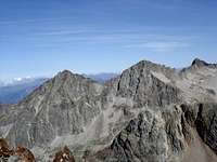 Quayrat and Lézat, W face
 Lézat, SW face
The Pic Lézat (3107m) is one of the big mountains of the area of Portillon d’Oô especially for the famous ridge what join the summit with the Pic Crabioules. The normal route from Refuge du Portillon (2568m) had as well some rock climb of F+ (I+) and it’s not a walk-up. As curiosity exist an easiest route (F.) from the N.E. but it’s really long and less frequented across a bad terrain from Refuge du Maupas.
The great ridge East contain the four Aiguilles de Lézat, four peaks with more than 10 meters over the ridge and for this reason includes in the official list of peaks of 3000m of the Pyrenees: Aguja Superior (3069m), Aguja Central NE (3058), Aguja Central SE (3058) and Aguja Inferior (3023m). The ridge is generally climbed from Crabioules and is AD+ with some step crossings of IV. It’s a beautiful ridge but only for expert rock-climbers and it contains another two peaks of the list of 3000m, the Punta Mamy (3048m) and the Punta Lacq (3010m), near of Crabioules.
Routes:
-The normal route (F+) is from Refuge du Portillon (2568m). It exist several options to reach the Refuge du Portillon but the normal path is from Granges d’Astau (4h). Another option is the traverse from the Spanish valley of Benasque, but is longest and the return is long as well. In this case it’s reasonable the climb of the peak and the descent to the refuge to spend the night after the return but generally is most useful to climb Perdiguero but the descent of Lézat is hardest than this peak and generally the mountaineers don’t use this route.
-The second route most used is probably from the Refuge de Maupas (2430m) but the beginning required a little descent of 200m to a point near of the cable way of the refuge. Reaching the Cirque de Carbioules we'll climb searching between Grand Quayrat y Lézat the access to the spun NW of the peak (F+).


Getting There
Trailheads: Granges d'Astau.Access to Granges d'Astau:
-French: the approach to the village of Montréjeau had good highways. The access to Montréjeau is in the road A-64 (E-80) between Tarbes and Toulousse. From Montréjeau we'll follow to Bagnères de Luchon. In Luchon we’ll follow the signals “Col de Peyresourde”. After 2-3 km in the village of Cazeaux de Larboust is the entry to the road of Granges d’Astau (1160m).
-Spanish: the access is possible at West in tunnel of Bielsa, or at the East, in the tunnel of Vielha.
-Approach to Bielsa: from Huesca to Ainsa. In Bielsa you’ll take the tunnel of Aragnouet-Bielsa to France. It's necessary to reach the village of Arreau to turn to the east to Val Louron, the first valley of Luchon, or following across the Col of Peyresourde (1569m) and before of Bagnères de Luchon is the access (see above).
-Approach to Vielha: from the city of Lleida to village of Pont de Suert (N-230), and across the tunnel of Vielha you’ll entry in valley of Aran. Before the village of Bosost is the road to Col du Portillon (1293m) to cross the border to France. The road D-618 go directly to Bagnères-de-Luchon.
The camping it's not allowed.
Red Tape
The reserve in the refuge is advisable (80 places).You're in the Park National of Pyrenees with rules about conservation of wildlife.
Camping
Refuge de Espingo (80 places, CAF)Refuge du Portillon (80 places, CAF)
Refuge de Maupas (35 places, CAF)