
-
 4537 Hits
-
 79.04% Score
-
 10 Votes
|
|
Mountain/Rock |
|---|---|
|
|
46.75253°N / 11.41900°E |
|
|
Hiking, Skiing |
|
|
Summer, Fall, Winter |
|
|
7920 ft / 2414 m |
|
|
Overview
 Karnspitz / Cima di Quaire Karnspitz / Cima di Quaire |
The Sarntal Alps / Monti Sarentini, as has been noted elsewhere, are a mountain range consisting of lower mountains, which are positioned neatly in horseshoe shape around the Sarntal Valley. About halfway up, near Astfeld / Campolasta the horseshoe this valley splits in two, Penser Tal / Valle di Penes in the north and Durnholztal / Valdurna to the south. In between these valleys you will find a ridge of the remotest mountains in the range. Named after its central summit Gentersbergspitze / Monte Ganda, Gentersbergkamm / Cresta Ganda starts at Astfeld / Campolasta and ends in Durnholzer Joch, a saddle which separates the ridge from the higher mountains of the eastern horseshoe. The mountains on the crest reach elevations slightly higher than 2400m while the saddles which separate them are rarely lower than 2200m.
 |  |  |
Among the five mountains, which constitute the crest the two endpoints are the most popular ones: Radlspitze / Cima Rodella above Astfeld / Campolasta and Karnspitz / Cima di Quaire above Durnholz / Valdurna. To reach them, however, you will have to scale more than 1200m of elevation which ensures that only determined hikers undertake the ascent. The big prize is the traverse of the whole ridge, an undertaking of 9h duration if you manage to be in time for the last bus after coming down from the ridge.
 |  |  |
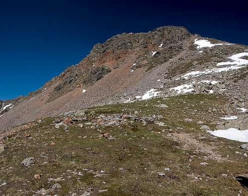
Karnspitz / Cima di Quaire is the easternmost of the mountains on the crest and stands more or less directly above Durnholzer Joch. The saddle connects the villages of Pens / Penes and Durnholz / Valdurna with each other but rarely gets climbed unless to reach the summit of Karnspitz / Cima di Quaire. The mountain's rock composition is typical of the Sarntal Alps: a very brittle mixture of schist and gneiss, which can be difficult and dangerous to tread upon. Both the east and west ridges of the mountain have sections of steep breakaway terrain which cannot be protected.
 |  |  |
The summit offers wonderful views of the surrounding mountains. The height of 2414m, which is well below the 2700 odd metres that the higher mountains of the Sarntal Alps reach, ensures that the local summits dominate the vista. Ötztal Alps, Stubai Alps and Zillertal Alps only peep through in between. Nevertheless Karnspitz / Cima di Quaire has proven to be a good spot to study their highest mountains. During WW I the Austrian troops must have decided the same as they established a position at the base of the east ridge of the mountain. The area didn't see any fighting but here the two valleys and with them the northern approach to Bolzen / Bolzano could be secured. Today only the lower walls of the position are left standing.
360° Summit Panorama
  |
Getting There
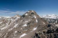
 The eastern Sarntal Alps above Durnholzer Jöchl
There are two reasonable trailheads for Karnspitz / Cima di Quaira, one at Durnholz / Valdurna one in Pens / Penes, both in Sarntal / Val Sarentino
- Durnholz / Valdurna trailhead
- Take Brenner Motorway A22 to Bozen / Bolzano
- Drive through the city, following signs to Sarntal / Val Sarentino on SS508
- At Astfeld / Campolasta turn off onto SP137, direction Durnholz / Valdurna. You have to park outside the village and will be charged a fee of 3€.
- For Pens / Penes stay on SS508 until you reach the village. You can also reach the village from Sterzing / Vipiteno across Penser Joch / Passo di Penes (also SS508).
Red Tape
 On the west ridge of Karnspitz / Cima di Quaire
There is no red tape in this area. Except for a few sheep and goats the area is not used for farming. In Durnholz / Valdurna you will have to pay a fee of 3€ for parking.
Accommodation
Eisacktal / Valle Isarco
Bozen / Bolzano
Weather Conditions
Maps & Books
Maps
- Digital Maps
- Regular Maps
- Sarntal/Val Sarentino
Kompass Map WK 056
1:35.000
ISBN: 3-85491-340-0
- Brixen / Bressanone
Kompass Map WK 56
1:50.000
ISBN: 3-85491-063-0
- Bozen / Bolzano
Kompass Map WK 54
1:50.000
ISBN: 3-85491-061-4
- BOLZANO-RENON / BOZEN-RITTEN-TSCHÖGGLBERG
Tabacco Map 034
1:25.000
- MONTE SARENTINI / SARNTALER ALPEN
Tabacco Map 040
1:25.000
- Sarntal/Val Sarentino
Books
- Bozen-Salten-Schlern
Kompass Guidebook WF953
Kompass Verlag
ISBN: 3-85491-406-7
- Rund um Bozen
Helmut Dumler
Rother Verlag
ISBN: 3-7633-4267-2