

|
|
Mountain/Rock |
|---|---|
|
|
40.08800°N / 105.633°W |
|
|
12979 ft / 3956 m |
|
|
Mount Toll Overview
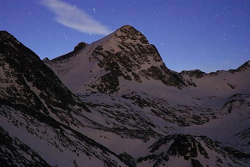
The Colorado Indian Peak Wilderness is home to many of the best hiking and climbing routes in the state. Only two hours from Denver, they are a popular destination for the novice day hiker, so start early and you can get some solitude. I have personally developed a passion for this magnificent area and will continue to add more of these beautiful mountains to Summitpost in the future. from the popular Brainard Lake Trail, many have looked at Toll and asked, "What's that mountain!" I personally believe Mount Toll (12,979 ft.) is the king of the Blue Lakes Drainage, outshining its higher and more popular neighbors, Paiute Peak (13,088 ft.) and Mount Audubon (13,223 ft).
Located on the Continental Divide about .6 miles south from Paiute Peak, Mount Toll offers a variety of mountaineering. Anyone with experience climbing Toll's 5.6 North Ridge Route, or the 5.6 Northeast Face is welcome to add the route to this page. I will describe the standard class 2 route from Long Lake Trailhead.
If you are going to try Mount Toll, allow plenty of time, it is 10.5 miles and 3,300 ft. of vertical. You can also do Mount Toll from the Mitchell Lakes Trailhead. In fact, a Long Lake approach with a Mitchell Lake decent would be a nice tour of two beautiful drainages. If you have time and the energy, go back to Pawnee Pass and continue another .5 mile up and over point 12,878 and on to Shashoni Peak (12,979 ft.) The views of Apache and Navajo Peak are to remember. From the summit of Shashoni you can drop straight down into the basin and eventually meet up with the Pawnee Pass Trail, albeit it is quite steep and will test your knees. Add about another hour and a half and 700 vertical to get from Toll to Shashoni.
Long Lake TH-Brainard Lake
To reach the Brainard Lake Road from the north follow Colorado 72 or the Peak to Peak Highway, south for 10.2 miles from the junction with highway 7. For the southern approach, go north 12 miles from Colorado 72 in Nederland to the town of Ward, the Brainard Lake Road is just north of here. Turn west on Brainard Lake Road and go 5 miles on paved road to Brainard Lake. Follow the Long Lake Trailhead signs another .5 mile to a large parking area. There is a $6.00 fee to enter this recreation area.
 |
Red Tape
- A $7.00 fee to enter the Brainard Lake area. The area is closed from October to early June. You can buy a season parking pass.
- Here is a summery of the Indian Peak Wilderness Rules and Regulations.
- Motorized vehicles are not permitted, including bicycles.
- A permit is required for camping in the wilderness area between June 1 and Sept. 15. Permits are issued for 19 travel zones within the Indian Peak boundaries. Permits are $5.00 at the following offices. For information or to apply for a use permit, contact the U.S. Forest Service, Boulder Ranger District, 2140 Yarmouth Ave., 303-541-2500, or the Sulphur Ranger District, 9 Ten Mile Drive, P.O. Box 10, Granby, CO 80446, 1-970-887-4100. For recorded information, call the Indian Peaks Wilderness Information Line at 303-541-2519.
- Only a certain number of groups are allowed in each travel zone for overnight camping. Camping is limited to two weeks in any four-week period; the two weeks can be in any travel zone.
- Organized groups (maximum size of 12) must have permit for camping or hiking at all times.
- Campsites must be at least 100 yards from lakes and streams.
- Fires are prohibited east of the Continental Divide. Fires are allowed in certain areas west of the divide.
- Dogs must be leashed.
Peak to Peak Camping
Here is an excellent link for Colorado Camping Reservations. An additional reservation fee of $8.65 is charged for this service. It might be worth it.
Most campgrounds in Roosevelt National Forest offer drinking water and toilet facilities. Approximately half are on a first-come, first-served basis; the rest are on a reservation system.
To reserve a campsite, call 1-800-280-2267for the hearing impaired), or register online via the National Recreation Reservation Service Internet site at http://reserveusa.com. Reservations can be made up to 240 days in advance. A camp fee of $12 per night, plus $6 for each additional car, is charged at all campgrounds with water systems. Services and fees discontinue when use declines, usually early to mid-October. - CAMP DICK is eight miles south of Allenspark on Colorado Highway 72, and one mile west of Peaceful Valley campground. This 41-site campground at 8,640 feet on Middle St. Vrain River offers some multifamily campsites, tent and trailer pads, drinking water, vault toilets, fire rings, barbecue grills, trash pickup and picnic tables. Reduced services Sept. 16-November, weather permitting. Twenty campsites can be reserved from Memorial Day weekend through mid-September.
- KELLY DAHL is three miles south of Nederland on Colorado Highway 119. The 46-site campground at 8,600 feet offers tent and trailer pads, drinking water, fire rings, vault toilets, a children?s playground, picnic tables, barbecue grills and trash pickup. Reduced services Sept. 16-November, weather-permitting. Twenty-six campsites can be reserved through mid-September. The rest are first-come, first-served.
- OLIVE RIDGE is one mile north of Allenspark on Colorado Highway 72. The 56-site campground near Rocky Mountain National Park and the North St. Vrain River offers tent and trailer pads, drinking water, vault toilets, picnic tables, fire rings, barbecue grills, trash pickup, a children?s playground and an amphitheater. The campground at 8,350 feet is the starting point for many trails leading into the mountains. Twenty-seven sites are available by reservation from Memorial Day weekend through mid-September. The rest are first-come, first-served. Reduced services Sept. 16-November, weather-permitting.
- PEACEFUL VALLEY is eight miles south of Allenspark on Colorado Highway 72, and one mile east of Camp Dick. The 17-site campground at 8,525 feet on Middle St. Vrain River offers tent and trailer pads, some multifamily sites, drinking water, vault toilets, fire rings, barbecue rings, picnic tables and trash pickup. Eight sites can be reserved from Memorial Day weekend through mid-September. Horse rentals available at nearby stables. Reduced services Sept. 16-November, weather-permitting.
- PAWNEE is six miles west of Ward in the Brainard Lake Recreation Area on Brainard Lake Drive (County Road 102) off Colorado Highway 72. The 55-site campground at 10,360 feet offers tent and trailer pads, drinking water, picnic tables, fire rings, barbecue rings, hiking, biking, fishing and nonmotorized boating. The campground closes Labor Day, but the area remains open for recreational day use year-round.
- RAINBOW LAKES is 13 miles north of Nederland and five miles west of Colorado Highway 72, down a rough gravel road at the turnoff for the Colorado Mountain Research Station (Forest Road 298). The 16-site campground at 9,960 feet offers tent and trailer pads, tables, fire rings, barbecue grills and vault toilets, but no drinking water or trash pickup. Reservations are not accepted. Campground closes at the end of October. Fee is $6 per night, plus $5 per additional vehicle.
(Note: Most of the above info copy and pasted from this site.)
Current Conditions
Click image to enlarge
The Brainard Lake Recreation Area is closed from mid October to mid June every season. It is approximatly a 5 mile drive from the gate closure to the trailheads during this stretch of closure. Usually by early April the snow has melted off the paved road leading to the trailheads. You can easily ride a bike to the TH, many people do.
External Links