April 11, 2005 - The initial posting is finished: hopefully improvements will follow
April 13, 2005 - Inserted as signature photo the present Photo of the Week
April 14, 2005 - Added some interactive links to other pages of the Gran Paradiso Group
Overview
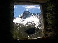
Herbetet (3.778m) belongs to the Gran Paradiso Group. It is one of the most beautiful and elegant peaks of Valle d'Aosta; therefore, even though some ten summits in the group are taller, Herbetet is as fascinating as Grivola, Ciarforon, Torre del Gran San Pietro, and Roccia Viva. Just as other summits in the Gran Paradiso Group (Grivola is a case in point), Herbetet looks quite different depending on the viewpoint. In spite of this, it is easily identified, but one has to point out that it is not visible from the valley floors, in its immediate proximity, of both Valsavarenche and Valle di Cogne.
Seen from the north--especially from Punta Rossa della Grivola--Herbetet looks like an almost perfect pyramid. From that direction one readily identifies the East ridge, the NNW arête, and the West ridge, which, out of the observer's sight, joins the South ridge. A red, forked tower marks their intersection. The NNE arête, which descents toward Colli dell'Herbetet, is not easily made out from this angle.
To have a better view, one should move to the opposite side of Valnontey. From there, the East ridge is right in front of the observer, who also sees the NNE arête and the South ridge. The latter forms the beginning of the long, spectacular, and challenging ridge that connects Herbetet to Gran Paradiso, going through Col Bonney (3.587m), Punta Budden (3.683m), Finestra di Tzasset (3.638m), Becca di Montandayné (3.838m), Colle di Montandayné (3.723m), Piccolo Paradiso--whose summit is adorned by beautiful spires including Punta Vaccarone (3.868m), Punta Farrar(3.921m), and Punta Frassy (3.926m), Colle del Piccolo Paradiso (3.877m) and, finally, Gran Paradiso (4.061m). At last, Herbetet looks quite different when seen from SW. For instance, from the vicinity of the Chabod Hut, one only sees a series of spires-easily confused, at first glance, with the nearby Punta Budden. Four glaciers grace the slopes of Herbetet. The NE side is partly covered by the remnants of the namesake glacier; on the NW side, vertical cliffs rise for almost 500m from the Gran Neyron Glacier, while the SW face descends to the Montandayné Glacier. Finally, the treacherous Tsasset Glacier lays to the SE of the peak.
First Ascents
First ascent (N-NE) Arête): L. Barale with A. and G. Castagneri, (Aug 22th, 1873).
In winter: A. Berthod, V. Marcoz, Toni Ortelli and Remo Chabod, (Dec28th, 1936).
E Ridge: G. Yeld and G. P. Baker with U. Almer and J. Jossi, (Aug 03th, 1881).
N-E Wall: G. Stallard, A. L. Ormerod, J. Ogi-Müller and A. Müller, (Aug 03th, 1891), in descent.
S Ridge: F. W. Oliver with A. and B. Supersaxo, (Sep 20th, 1895).
S-E Wall: R. Ravelli and G. A. Rivetti, (Aug 28th, 1920).
N-NW Ridge: R. Chabod and M. Mila with L. Degioz, (Aug 01th, 1928).
W Face: A. Bonacossa, and L. Binaghi, (Sep 22th, 1932).
Getting There
BY CAR: Valle di Cogne
From Torino, Milano, etc: Motorway A5. Exit at Aosta Ovest. Drive to the near Aymavilles. Follow the directions for Valle di Cogne.
From Switzerland: through the Grand Saint Bernard Tunnel or the namesake Pass.Drive to Aosta, then follow the direction for Courmayeur on SS.26. Just after Sarre, turn to the left, in the direction of Valle di Cogne.
From France: through Mont Blanc Tunnel or Petit St. Bernard Pass. It isn't necessary to take Motorway A5: you can drive on SS.26, in the direction of Aosta. Before arriving at the Village of Sarre, turn right following the sign for Valle di Cogne. After Aymavilles, the SR.47 crosses the Villages of Vieyes, Epinel and Cretaz and after about 25 Km arrives at Cogne (1.534m).
From Cogne you can get the Village of Valnontey (1.666m).
Valsavarenche
From France: through the Mont Blanc Tunnel or the Col du Petit Saint Bernard: you can drive on SS.26, following the direction for Aosta and, before arriving in Villeneuve, turn right towards Introd. Alternatively, you can take Motorway A5 (at Courmayeur or Morgex) and exit at Aosta Ovest.
From all other directions: get to the Aosta Ovest exit of Motorway A5. Then drive along SS.26 Aosta, direction Courmayeur, and just after Villeneuve turn left towards Introd. Shortly after Introd, you arrive at a junction: turn left, entering in Valsavarenche and then, before arriving at Pont (1.978m) where the road ends, you will touch the Villages (Degioz, Eaux Rousses, etc) where the pathways to "Casolari" Superiori di Leviona, Sberna Bivouac, Chabod Refuge start from.
BY PLANE:
Aeroporto "Corrado Gex" Saint Christophe (Aosta).
Historical Outline
In the past, confusion abounded when it came to naming the peaks in the Gran Paradiso Group. Case in point, the Gran Paradiso summit itself, whose name is first recorded in official documents only in 1827, though sometimes referred to what is now known as Torre del Gran San Pietro. Other names given to the main summit included, beside a mysterious Monte Iseran: Grande Paroi, Monte del Broglio and Montandaynè. These names currently identify other peaks in the group. Gran Paradiso was also called L'Evesqueur, since for eight centuries the title of Count of Cogne was conferred on the Aosta bishop, and the peak is located in the Cogne territory. Turning our attention to Piccolo Paradiso, we find that, after a short interlude in which it was given the name Pic dell'Infortune, it was known for a while as Becca di Montandaynè, while the current Becca di Montandaynè was called Gran Serra-a name that has now been given to another peak of the group.
As for Herbetet, it was also sometimes called Gran Serra, in which case, the name "Herbetet" went to--guess what--Becca di Montandaynè. In the end, though, given that our summit rose near the col, glacier, and pastures that already carried the Herbetet name, rationality prevailed. There is little doubt that the difficulty in discerning the peaks from the neighbouring valley floors contributed to the toponymic uncertainties.
Starting Points
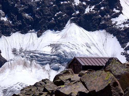
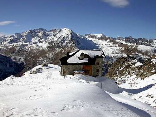
From Cogne: Fixed Bivouac Lucio and Lionello Leonessa (2.910m), near Herbetet's east ridge. Difficulty: E (Hikers). Reachable from Valnontey (see the following itinerary).
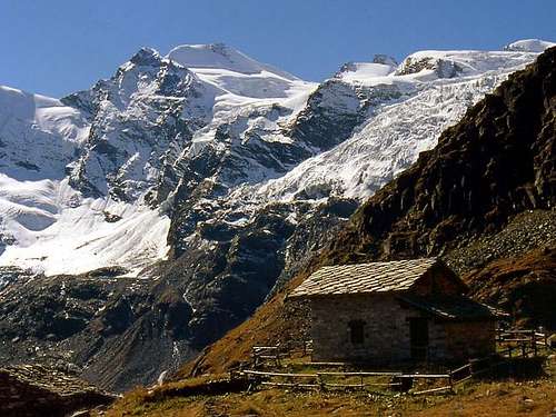
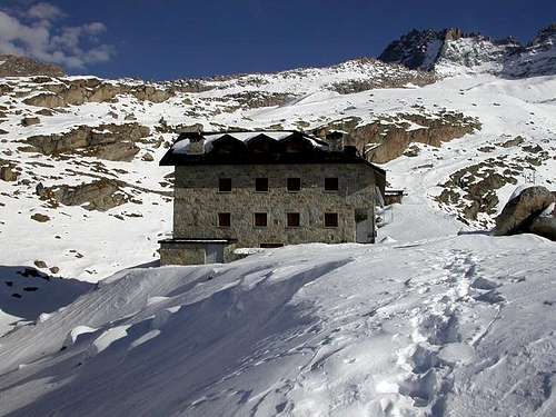
From Valsavarenche: Federico Chabod Hut (2.750m), just near Costa Savolera, on the orographic right of Valsavarenche. Difficulty: E (Hikers) sleeps 40 (in winter it sleeps 16).
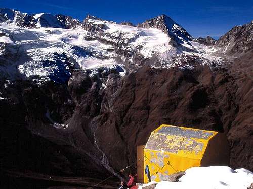
Fixed Bivouac Sebastiano and Renzo Sberna (3.414m), at the base of the west ridge of Herbetet on the Western Col of Gran Neyron. Difficulty: PD (Not so difficult), rope, axe and crampons. In both cases the path starts from Pravieux (1.870m), about 3 km (1.960m) and about 35 km from Aosta.
A further starting point can be: "Casolari" di Leviona Superiore (2.648m), where a vaulted building may offer shelter in case of need. It is placed in the namesake side valley, which can be reached starting from Degioz or, from Eaux Rousses, along the convenient royal hunting mule--track which King Vittorio Emanuele II di Savoia had built. Difficulty: E (Hikers)
East Ridge
Note: I climbed this route some thirty years ago. Memories have faded in the meanwhile, and conditions have likely changed. Hence, I prefer not to describe this itinerary in a separate route page.
First day: From Cogne (1.534m) one quickly reaches the Village of Valnontey (1.666m) where parking is available in the large square near the center of the village. Start the ascent on the orographic right (climber's left) of Valnontey. Once past the Hamlet of Valmiana (1728m), reach the Erfaulet Bridge at (1.830m). Cross the bridge and continue along the trail until a fork at (2.040m)(1h'40-2h'00). Take the right branch, cross a small bridge and climb along a winding path to the "Casolari dell'Herbetet" at (2.435m) Here you will find a hut of the Gran Paradiso National Park. Continue along the steeper winding trail that climbs the grassy slopes. Once in the upper Herbetet Valley, keep slightly left; once across the Herbetet brook, climb again in the direction of the morainic ridge surmounted by the east ridge of Herbetet. (Follow the signs!) In its vicinity you will find the fixed Bivouac named after the brothers Lucio and Lionello Leonessa (2.910m) sleeps---12, 4h'15-4h'45 from Valnontey. Be warned that in summer the bivouac may be crowded and that it may be hard to find in the dark or in the fog.
Second Day: Reach the base of the cliff known as "Tours dell'Herbetet" at about (3.300m). Climb the rocky band and the steep Herbetet Glacier to reach a saddle at about (3.280m). Here the ascent of the East ridge proper begins. Keep preferably to the north side of the ridge, where the rock is looser than on the south side, but much less steep. The gendarmes along the ridge are usually passed on the North side, but you can add fun and exposure to your ascent by not leaving the crest of the ridge, since the rock of the gendarmes is usually quite good. The last 150 m before the summit (3.778m) are the most airy and need some care (5h'00/7h'00 from the bivouac).
Descend: by retracing your steps. The route is classified from PD to AD (from not so difficult to rather difficult) depending on the conditions. In any case, it is recommended to expert climbers who are in good shape.
Gear
Mountaineering equipment including rope, axe, crampons, helmet, and a few pitons.
Red Tape
Within the borders of the P.N.G.P. (Parco Nazionale del Gran Paradiso), at the moment dogs generally are not allowed, except on a couple of trails, and camping is forbidden (except for climbers from sunset till dawn). No fees are due.
Campings
Wild camping in the Parco Nazionale del Gran Paradiso is strictly forbidden! There are three camping sites very near to Valnontey Village.
Mountain Condition
Meteo: you can find all the needed informations at the official site of the Valle d'Aosta Region:
"Guida dei Monti d'Italia-Gran Paradiso Parco Nazionale" E. Andreis, R. Chabod, M. C. Santis, Club Alpino Italiano/Touring Club Italiano, prima Ed. 1939; seconda Ed. 1963; terza Ed. 1980.
" A. Gegenfurtner, G. Klotz, F. Müller "Gran Paradiso" , Ed. Bergverlag Rudolf Rother, Monaco 1980 (in tedesco).
"Gran Paradiso - Itinerari Alpinistici e sci Alpinistici" di Franco Brevini Ed. Musumeci, Giugno 1982.
" G. Klotz "Gran Paradiso" Ed. Bergverlag GmbH Rother, Monaco 2005 (in tedesco).
"Diari Alpinistici" di Osvaldo Cardellina e Indice Generale accompagnato da Schedario Relazioni Ascensioni 1964-2019 (inediti).
"Rifugi e bivacchi in Valle d'Aosta", di Cosimo Zappelli aggiornata da Pietro Giglio, Musumeci Editore, Luglio 2002.
"Guida della Regione Autonoma Valle d'Aosta" di Mario Aldrovandi, Ed. S.P.E. di Carlo Fanton, Torino 31 Dicembre 1964.
"Guida delle Alpi Occidentali" di Giovanni Bobba e Luigi Vaccarone C.A.I. Sezione di Torino Volume II (parte II), 25 Maggio 1896.
MAPS:
Kompass "Gran Paradiso Valle d'Aosta Sentieri e Rifugi" Carta turistica 1:50.000.
I.G.C. Istituto Geografico Centrale "Valsavarenche-Val di Rhêmes- Valgrisenche" Carta dei Sentieri e dei Rifugi 1:25.000.
I.G.C. Istituto Geografico Centrale "Gran Paradiso-La Grivola" Carta 1:25.000.
I.G.M. Istituto Geografico Militare Foglio 41 I SO Gran Paradiso-I NE Cogne 1:25.000.
L'Escursionista "Valle di Cogne Carta dei Sentieri" (n° 10) 1:25.000.
L'Escursionista "Tour de la Vallée de Cogne Grand Paradis" Carta dei sentieri 1:25.000.
Enrico Editore Ivrea-Aosta "Gruppo del Gran Paradiso" 1:50.000.
Children refers to the set of objects that logically fall under a given object. For example, the
Aconcagua mountain page is a child of the 'Aconcagua Group' and the 'Seven Summits.' The
Aconcagua mountain itself has many routes, photos, and trip reports as children.
Parents refers to a larger category under which an object falls. For example, theAconcagua mountain page has the 'Aconcagua Group' and the 'Seven Summits' asparents and is a parent itself to many routes, photos, and Trip Reports.

 29728 Hits
 98.72% Score
 88 Votes