
|
|
Mountain/Rock |
|---|---|
|
|
43.91440°N / 114.656°W |
|
|
10243 ft / 3122 m |
|
|
Overview
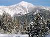
Gladiator's south face is striking when viewed from the Galena Nordic Center

*Will have more photos later*
One of the northernmost summits of the central Idaho's rugged Boulder Mountains, Gladiator Peak is pyramidal in shape, with its south face forming in impressive background to the Galena Lodge. Gladiator's traffic in winter far outnumbers that in summer because of its convenient location close to a highway, its open faces, and prominence behind a popular nordic ski area. Though short, the hike up this mountain is very steep and constant in pitch.
Whether snowshoeing, skinning, or just scrambling up Gladiator Peak, all will enjoy unparalleled views not only into the White Clouds, but a somewhat rare look into the seldom visited West Fork of the East Fork Salmon River. This enormous drainage is so isolated that many 10,000+ peaks have yet to be climbed here.
For those of you wishing to do a non-technical hike, the route provided below offers a class 2 ridge with no obstacles, perfect for those of you who wish to begin the world of scrambling.
 |  |  |  |
Getting There And Main Route
For access to Gladiator Peak from Ketchum, begin by driving 30 miles northwest of Ketchum to the Galena Day Lodge parking lot. From the parking lot drive up Gladiator Creek Road to it's end, in about 1.5 miles. Here you will find the trailhead for Gladiator Pass Trail. Sign the register and begin hiking on what seems like a nice mellow trail. After about three-tenths of a mile, the trail suddenly turns north and begins a steady trek up the Gladiator Creek drainage. In about 2 miles from where you left your car, Gladiator Pass, around 9,800 feet or so, will be at your feet with the toughest part of the climb still ahead. From the pass, the trail heads downhill into the seldom, if ever, visited East Fork West Fork Salmon River. Dont go that way. Gladiator Peak's northwest ridge will be to your left, begin by climbing through Boo Radley-Like, White Bark Pine trees to some loose scree. For the next few hundred feet, a mx of more scree, followed by some boulder hopping a wait you. Once on the summit, soak in the views and take a minute, because the descent on Gladiator Pass Trail will surely give your knees a good wear.
Gladiator Peak's West Ridge may also be climbed. BidDan's snowshoe report best describes the West Ridge Route on his wonderful website IdahoSummits.
 |
Red Tape
As with almost all of Idaho's mountains, no fees or passes are required for this enjoyable hike.
When Not To Climb?!
I would say the only excuse, year-round, not to climb this peak would be high avalanche danger. It is an easy hike, a relatively short snowshoe, and I've been told a very fun back country ski trip.
Idaho Tidbits
There are two famous quotes that were said about hundred years ago about Idaho and they could not be more true.
"If it werent for Idaho's snow-catching mountains, the state would be nothing more than a flat desert, filled with sage and grass"
"Pick a spot in Idaho, anywhere, just as long as you have a 360 degree view, you will see a mountain; it may be miles and miles away, it may be staring you right in the face, or look down, it may be right under your feet"
Idaho is one of the United State's most mountainous states. More than thirty mountain ranges run from the north to the south. Idaho has the largest area of continuous wilderness in the Lower 48 states. It also has the longest undamned river as well. They say if you flattened out all of Idaho it would be bigger than Texas. Thats saying a lot for a state with just 1.4 million people, yet it is the 3rd fastest growing one in the nation. There are over 500 peaks that rise above 10,000 feet and over 150 above 11,000, many yet still to be climbed. The deepest gorge in North America lies on the Idaho Oregon border, though the most precipitous drop is from the Idaho side, nearly 8,000 feet from the top of He Devil to the Snake River. more to come!
Mountain Conditions
Coming Later