
-
 5401 Hits
-
 84.27% Score
-
 18 Votes
|
|
Mountain/Rock |
|---|---|
|
|
47.44498°N / 10.84196°E |
|
|
Hiking, Skiing |
|
|
Spring, Summer, Fall, Winter |
|
|
7372 ft / 2247 m |
|
|
Overview
 Hochschrutte (right) and the northern rockfaces as seen from Kramerspitz ascent
Daniel , the highest Ammergau Alps peak, is the eastern culimation point of a 7 km long, west - east running ridge, the southernmost ridge of the Ammergau Alps. In the center of this ridge is Plattberg, also called Hochschrutte, a broad and high peak, the second highest of Ammergau Alps, the south side of the summit zone built up with broad and huge rock slabs - they gave the name Plattberg - the north side instead a nearly perpenicular rockface, dropping down dramatically to Pitzen valley.
As Daniel attracts most of the hikers in this southern Ammergau chain the other summits of this ridge like Hochschrutte tend to be less crowded. Most trails to the top are not very well maintained and marked. Plattberg and the neighbouring summits still are a sort of insider tip as is the complete traverse of the chain from Zinggerstein / Kohlbergspitze to Daniel - an epic but beautiful.
In early springtime with good snow condition Plattberg is an interesting ski tour. If there is enough snow in february and with some sunny days you get excellent corn snow slopes down from Plattberg.
Most of the south slopes of Hochschrutte are free of snow in april or may. So Plattberg is an interesting hike from springtime to November / December, depending on the amount of early winter snow.
But to my opinion the clear and still warm autumn days are best for summiting. Plattberg is an excellent lookout and there are nice meadows near the summit for a long nap in the warm autumn sun while the dry gras around you whispers good bye to the last summer ........................
 Plattberg summit Plattberg summit |  Plattberg west ridge scramble Plattberg west ridge scramble |  Plattberg east ridge scramble Plattberg east ridge scramble |
Getting There
 Hochschrutte as seen from Pitzenegg
Main trailheads are
all located in the valley south of the Daniel chain alongside road number 179 of Austria.
You reach these villages
from Munich
from Innsbruck / Sankt Anton
from Reutte / Lechtal / Füssen
By railway
The “Außerfernbahn” links Garmisch-Partenkirchen to Reutte with railway stations at each trailhead village.
Check the railway schedule here
Main Routes Overview
Southern ascents: Hochschrutte summit view Hochschrutte summit view |  Hochschrutte east ridge view Hochschrutte east ridge view | 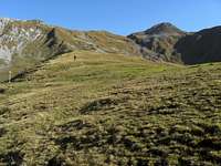 South ascent to Hochschrutte east ridge South ascent to Hochschrutte east ridge |
Traverse:
 Summit panorama to the south
Red Tape & Accommodation
 Hochschrutte as seen from Geierköpfe ascent Hochschrutte as seen from Geierköpfe ascent | 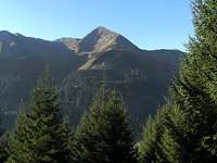 Bleispitze as seen from Hochschrutte ascent Bleispitze as seen from Hochschrutte ascent |
There are no special regulations as far as I know.
You find accommodation at:
Mountain huts:
Gear & Mountain Condition
 Plattberg ( Hochschrutte)
Plattberg is an all seasons summit.
In winter and early spring, Hochschrutte is a frequented ski tour. Due to the southern exposition of the main routes the snow conditions can be difficult (e.g. huge avalanches). The village name Lähn, a regional dialect word for avalanche, is telling .......
You need full ski hike gear and avalange gear. Plattberg is a beginners ski tour, accompanied by an advanced, though steep in some parts.
Check the Tirol avalanche bulletin here.
In spring, summer and autumn, Plattberg is a lonely and simple hike. Full hiking gear is needed. Despite of some easy rock scrambling on the west and east ridge there are no special difficulties. The trails and foot tracks are sometimes steep and baldy marked.
Current Weather:
Maps & Guide Book
 Plattberg as seen from Lähn trailhead
Maps
Guide Book
Alpenvereinsführer alpin
Allgäuer Alpen und Ammergauer Alpen
Bergverlag Rother, München, 2008