
|
|
Area/Range |
|---|---|
|
|
42.57500°N / 19.55758°E |
|
|
7165 ft / 2184 m |
|
|
Overview
  |
 |
 |
 |
 |
 |
 |


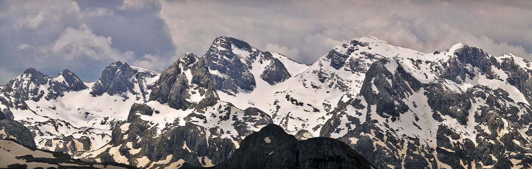
ŽIJOVO (KUČKE PLANINE) mountain range belong to Montenegro's high mountains region. ŽIJOVO (ZIJOVO) is located in the southeast part of Montenegro and represent one of least known and most remote mountain areas in that country. That's the reason why first alpinistic ascents happend at the end of 90's. Žijovo is bordered by the rivers Cijevna, Mala Rijeka and Veruša, Rikavačko Jezero lake, and also the border mountain wreaths to the south and southeast. The mountains of Žijovo range are the closest neighbour of Albanian part of impressive PROKLETIJE range. Some authors has a opinion that Žijovo is a part of Prokletije, but the fact is that's a unique mountain range with its special and recognizable outlook. Also, ŽIJOVO is one of the most beautiful and most picturesque mountain range in Montenegro.
That beautiful mountain range has a more than 20 peaks which are higher then 2000 m. The highest peak of the range is Surdup (2184 m). Highest peaks of Žijovo are:
- Surdup (2184 m)
- Štitan (2165 m)
- Maglić Kučki (2142 m)
- Kanjavi Vrh (2140 m)
- Žijevo (2131 m)
- Šila Velja (2129 m)
- Stožina (2120 m)
- Ždrebarnik (2103 m)
- Vilijar (2096 m)
- Vila (2093 m)
- Jovanov Vrh (2084 m)
- Smojan (2064 m)
- Velji Vrh (2063 m, 1916 m)
- Mali Maglić (2060 m)
- Strungeze (2053 m)
- Pasjak (2051 m)
- Krisitor (2024 m)
- Treskavac (2024 m)
- Veliki Toljevac (2022 m)
- Šila Mala (2022 m)
- Viljenica (2009 m)
- Prijun (2005 m)
- Pločnik (2003 m)
- Bigeze (1988 m)
- Beškeza (1954 m)
- Veliki Torač (1914 m)
- Crna Planina (Suvovrh, 1911 m)
- Prasica 1882 m)
- Torač (1875 m)
- Kariman (1875 m)
- Kodra Kučka (1858 m)
- Hum Oraovski (1834 m)
- Debeza (1755 m)
- Kozenik (1650 m)
- Planinica (1566 m)
Geographically, this area is edged in the east and southeast by the river Cijevna and is the borderline with Albania. From the southwest is the Zeta plain. The west by the rivers Morača and Mala Rijeka and in the north by the rivers Veruša and Bukumirsko lake and Rikavačko lake. Although these mountains are in the south, their period of glaciation and glacial migrations can be seen in the relief formations of cirques, valleys, glacial riverbeds and sharply formed peaks. The specious plateaus of Stravče, Kržanja and Momče were formed by moraine and fluid glacial processes. Today's lakes Bukumirsko and Rikavačko are also remains of the Ice Age. As to the geological composition, a large number of ŽIJOVO mountains belong to the DURMITOR stone layers, with lesser relief forms of sharp jagged slopes, cascading rock falls and similar forms typical of the Karst. The northern and northeastern slopes of Žijevo are made of cretaceous limestone, covered by Durmitor stone layers and sediment.
Žijovo peaks offer you enjoyment in many beautifully summit panoramas. First of all, you can admire the impressive beauty of Prokletije range. From Maglić peak you can clearly enjoy in Komovi massif. Finally, Durmitor and Sinjajevina is also nicely visible.
Žijovo range is enriched by two beautifully and picturesque mountain lakes - Bukumirsko Lake and Rikavačko Lake. Bukumirsko lake is placed in the heart of the range and with its outlook gives a great contribution to the unique and recognizable and unique beauty of Žijovo. Main climbing routes to the highest peaks of Žijovo massif starting from Bukumirsko Jezero lake.
Second lake, Rikavačko Jezero lake is placed in deep grassy basin, below the rocky slopes of impressive and elegant Vila (2093 m), where the borderline passes over its summit.
Bukumirsko Jezero lake
Bukumirsko Lake is most recognizable symbol of Žijovo (Kučke Planine) mountain range. The lake is placed at 1448 m above sea level, between Torač, Velji Vrh and Gozd. The surface is 19.320 square meters, maximal depth is 16,8 m. The lake takes a water from the rain, by snow melting and from periodical springs from Katun Ivanović. About 15% of the lake is enriched by plants which is in expansion. The panorama of Bukumirsko lake with Pasjak, Štitan, Velji Vrh and Surdup peaks above it is really one of the most beautiful mountain scenery of Montenegro. |
Rikavačko Jezero lake
Rikavačko Lake is placed below the impressive and elegant Vila (2093 m) peak, on the place where the mountain range Žijovo (Kučke Planine) is separate from Prokletije. The lake is situated at 1313 m above sea level. The surface of the lake is 117.755 square meters. The lake is 525 m long and 235 wide. The coastline is 1640 m long. Maximal depth is 13,9 m. One part of the water of that like goes to Cijevna and Ribnica rivers. Rikavačko lake takes the water from the rain, by snow melting and from periodical stream Rikavac. |
Štitan & Surdup Route
 |
Veruša - Bukumirsko Lake (1443 m) - Jezerca (Štitan/Pasjak pass, 1773 m) 2h - Štitan peak (2165 m) 1h - Štitan/Surdup pass (2055 m) 30 min - Surdup summit (2184 m) 30 min
ACCESS: To Bukumirsko Lake from Podgorica or Kolašin, goes through the village of Veruša, along the Veruša River valley to the Mokro hamlet and then via a bad gravel road gravel road that descends to the shores of Bukumirsko lake.
The beginning of this trail is from Bukumirsko lake, at the same place and following the same marked path as for the ascents to peaks Štitan and Pasjak. The departure to Surdup peak connects with the pass towards the Štitan peak. The ascent goes westward to the Štitan-Surdup Pass. From there follow the steep grassy steppes of the southern slopes of Surdup to the Surdup peak, which is the highest peak of Žijovo mountain range. It is advisible to avoid the return across the Štitan summit, from the Surdup/Štitan Pass. Follow the marked path, near the north vertical of Štitan peak, across block-like-boulders, rock falls and rubble to Jezerca and the above mentioned crossroad of mountains Pasjak and Štitan. This marked path continues to Bukumirsko lake.
Note: No drinking water is available along this tour. The water spring is at Katun Torač, follow the marks for "Voda" or "Izvor" to find it.
Getting There

 Velji Vrh
 Veliki Toljevac
By car
Usual starting point to reach Žijovo range is Bukumirsko Jezero lake. That lake you can reach from few directions:
1. Podgorica-Kržanja-Kastrat-Bljuštura-Bukumirsko jezero: 45 km.
Asphalt road from Podgorica to Kastrat, than by macadam road more about 15 km.
2. Podgorica-Bioče-Veruša-Mokra-Bukumirsko jezero: about 50 km
Asphalt road from Podgorica to Topli Potok (few kilometers from
Veruša), than by macadam road more about 5-6 km.
3. Podgorica – Bioče – Brskut – Ubogi do – Bukumirsko jezero: 40km
Asphalt road to Brskut, then by macadam road more about 5-6 km.
4. Podgorica-Korita-Rikavačko jezero-Širokar-Mokra-Bukumirsko jezero: about 70 km.
Asfalt from Podgorica do Korita, than by macadam road more about 30 km.
For this road is necessary to drive with Jeep or some similar car, because the road is not easy for normal car.
5. Kolašin-Mateševo-Veruša-Mokra-Bukumirsko jezero: 40 km.
Asphalt road from Kolašin to Topli Potok, than by macadam road more about 5-6 km.
By Bus
To reach Žijovo range you can use the bus lines Podgorica-Veruša, Podgorica-Kržanja and Kolašin-Mateševo. Buses from Podgorica going every morning. Podgorica-Veruša is the most optimal option. From Veruša to Bukumirsko Jezero lake you can come by local taxi or by taxi from Kolašin town.

Camping
 Veliki Torač
 Meadow below Torač
You can freely camping inside of Žijovo range. Most optimal places for camping are near Bukumirsko Jezero lake and Rikavačko Jezero lake. Also on Katun Torač where you can find a water spring following a marks.
Meteo Info
Check Meteo Info for Kolašin town.Guides & Maps
PLANINARSKI VODIČ KROZ ŽIJOVO, Planinarski klub "Gorica" Podgorica, Podgorica 2008.In that guide you can find a basic information about Žijovo range and some basic routes. Also, the guide contens a map of whole Žijovo area and few parcial maps. You can buy it on the web site of PD GORICA.
The price of the guide is 5 Euro.