
|
|
Mountain/Rock |
|---|---|
|
|
42.48004°N / 19.76084°E |
|
|
8199 ft / 2499 m |
|
|
Overview
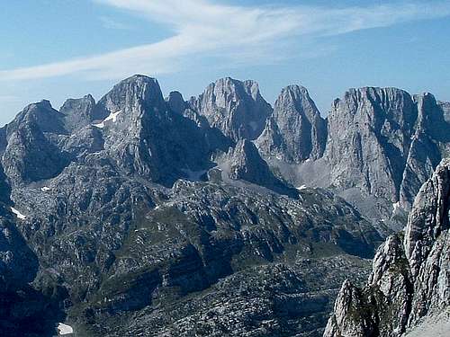
 Maja Shkurt on the left and Maja Lagojvet in the middle
PROKLETIJE mountain range stretches through the three countries, Montenegro, Serbia (Kosovo area) and Albania. Largest part of the massif is placed on Albanian territory, known also as a Bjeshket e Nemuna or also Northern Albanian Alps. Impressive peaks of Prokletije are separated between themself by beautifully valleys as are Grbaja, Ropojana, Valbona, Thethi, Buni i Vukoces and 6 Lakes Valley (Buni Jezerce).
Above the valley Buni i Vukoces, which is natural extensior of Ropojana Valley, is placed Maja Shkurt (2499 m), one of the most beautiful peak in whole Prokletije range. Maja Shkurt with its S-SE high rocky face standing above the valley Buni i Vukoces, in front of rocky massif of Maja Bojs (2461 m) and Scokiste (2396 m) peaks.
Closest neigbours of Maja Shkurt are Maja Lagojvet (2540 m), Maja Vukoces (2450 m) on NE, Maja Shnikut (2554 m) on SW and Maja Prozmit (2452 m) on S. As you can see on the map, Maja Shkurt peak is a part of longer mountain branche which starts on N from Rogopeč (Vezirova Brada) peak and than continue in SW direction and separate Ropojana Valley from Grbaja Valley. The part of the same mountain brance are also Jagnjičar, Ljuljaševića Karanfili, Karanfili, Forca (Fortit), Maja Vukoces, Maja Lagojvet, Maja Shnikut, Maja Prozmit and Maja Nigvacit.
Maja Shkurt you can approach from the valley Buni i Vukoces via Ropojana Valley from Gusinje town.
Summit View
 Groups of Maja Lagojvet (2540 m) and Maja Shkurt (2499 m) from Maja Shnikut (2554 m)
Maja Shkurt (2499 m) offer enjoyment in many beautifully summit panoramas. From the summit of that peak you can see many highest peaks of Prokletije/Bjeshket e Nemuna mountain range. First of all, Maja Jezerce (2694 m), the highest peak of Prokletije range is nicely visible. Maja Shkurt also offer beautiful view to Maja Lagojvet, Maja Shnikut, Maja Prozmit, Maja Nigvacit, Maja Bojs, Scokista, Maja Malisores, Maja Popluks, Maja Vukoces and Karanfili.
SUMMIT VIEW:
NW: Maja Nigvacit (2412 m)
NE: Maja Lagojvet (2540 m), Maja Vukoces (2450 m), Forca (2340 m)
S: Maja Prozmit (2452 m)
SE: Maja Bojs (2461 m), Scokista (2396 m), Maja Malisores (2490 m), Maja Alis (2422 m), Maja Kokervhake (2508 m), Maja Jezerce (2694 m), Maja Popluks (2569 m), Maja Ragomit (2472 m)
SW: Maja Reskulit (2490 m), Maja Visens (2517 m)
E: Maja Rosit (2524 m), Maja Kolata (Dobra Kolata 2528 m, Zla Kolata 2534 m)
W: Maja Shnikut (2554 m)
Getting There
 Maja Shkurt with its surroundings
 Maja Lagojvet left and Maja Shkurt right from the valley Stani Koprishtit
 Map of Maja Shkurt area
Gateway to Prokletije and Maja Shkurt (2499 m) peaks are Plav town and Gusinje town and Grbaja & Ropojana Valleys. Information how to get there:
By Plane
~To Beograd (Belgrade, Serbia&Montenegro capital) airport. Than with plane to Podgorica, capital of Montenegro, or with bus or car to Plav town.
~To Podgorica airport. Than with bus or car to Plav town and after to Gusinje town.
Information about flights find on the sites of JAT Airways, a former Yugoslav airlines, or on Montenegro Airlines.
By Bus
~Beograd (Belgrade)-Plav
~Podgorica-Plav
By train
~Beograd (Belgrade)-Bijelo Polje. Than with bus or with car (rent a car) to Plav and Gusinje.
By car
~Beograd (Belgrade)-Kraljevo-Novi Pazar-Plav-Gusinje.
~Podgorica-Kolasin-Andrijevica-Plav-Gusinje
Gusinje town and Plav town (in Montenegro) are the main destinations you would head first. In Gusinje you can buy everything (food, shampoo, soap, clothes,... and many other things), all what you need for few days of trekking and climbing in heart of Prokletije massif.
From Gusinje town you can go deeper in Prokletije massif through two valleys - Grbaja & Ropojana. Distance Gusinje - Grbaja valley: 7,5 km, (2 h of walking with big rucksack (backpack).
Also, from Gusinje town you can go to Ropojana valley, and farther across Montenegrin/Albanian border (with entry permit of albanian police) to center of Prokletije massif - Jezerski Vrh/Maja Jezerce/Lake Peak (2694 m) area.
Camping
 Branko Kotlajić hut
 Eko Katun in Grbaja Valley
In Grbaja Valley you can stay at Branko Kotlajić hut (open only when inhabited by members of Radnićki mountaineering club (www.pd-radnicki.rs) from Belgrade. It is possible to get the keys at the police station at Gusinje, but please take the hut clean when you leave it.
Second option is to stay in Eko-katun, which offers a restaurant, a bathroom with shower and simple accommodation in wooden bungalows (5€ per person in summer 2009). You can also camp next to those places for a small fee or higher up in the valley, possibly also for a small fee paid to local shepherds.
Camping anywhere higher in the mountains is free. At the higher part of Grbajski Zastan or Stani Koprishtit it is likely that you will not meet anyone else for several days, or maybe sometimes you will only come across local shepherds. Remember to protect the wilderness of those beautiful and unspoilt mountains and leave the place in a state you would like to find it.
Red Tape
 Maja Shkurt left and Maja Lagojvet in the middle, from Qatat e Verlla
Before you cross the border, you need a permit from Montenegrin police to climb the peaks on the border. Some important info:
a) you can get a permit at Montenegrin police stations at Plav or Gusinje and then register at the watchtower at Vusanje while entering Ropojana valley before going further to Albania;
b) you can get a permit via an Albanian embassy in your country;
c) it is impossible to get such a permit and it is illegal in all cases to cross the border outside official border crossings.