
|
|
Mountain/Rock |
|---|---|
|
|
42.29000°N / 19.47000°E |
|
|
7168 ft / 2185 m |
|
|
Overview
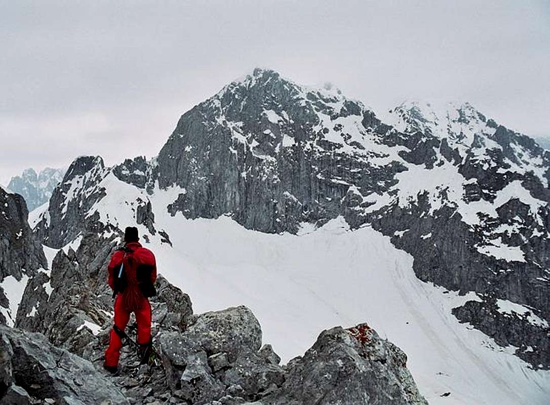
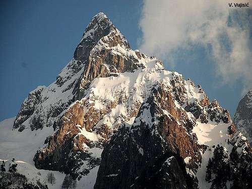 Impressive outlook of Ocnjak peak
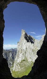 From Suplja Vrata
When you enter into beautiful Grbaja Valley in Montenegrin part of PROKLETIJE mountains, your first attention will attrack one impressive peak, which with it's sharp and elegant form, together with it's closest neighbour Karanfili peaks, dominate above deep Grbaja Valley. It's name is Očnjak. This peak, staying on left side of Grbaja Valley, will first tell you "Welcome" when you'll visit this magnificient area.
Očnjak (2185 m)(Canine Tooth)(read "Ochnjak") peak don't belong to group of highest peaks of Prokletije, but is for sure one of most attractive peak in Prokletije massif. Also, Oènjak is one of the most difficult peak for climbing in Montenegrin part of Prokletije massif. Specially in winter time, climbing of Ocnjak peak is something between high mountaineering and alpinism. This impressive peak each year invites many climbers to climbe it.
Because of it's sharp and steep massif, Ocnjak got it's name because it's rocky form is similar with canine tooth. This name is the new one. It's older names was Zvono (Bell) and Maja Neri i Krit (Frozen Man Peak). According the legend, one hunter was frozen on this peak, after nymph's decision. Reason is killing of mountain goats.
Till August 1962 existed just alpinism route to reach the summit of Ocnjak. In August 1962 group of climbers from Belgrade discovered new path (new route) which offers possibility to reach the summit also for others who are not alpinists.
The summit of Ocnjak offers extraordinary enjoyment in many summit panoramas as are view to impressive Maja Jezerce (2694 m), highest peak of whole Prokletije massif and Karanfili (2490 m) peaks, specially to amazing North Face of North Peak (2460 m) of Karanfili. This route is exposed on some places, so some mountaineering experience is needed!
LOCATION:
Ocnjak (2185 m) peak is located on NE from Kolac (Kolata, 2528 m), Rosni Vrh (Maja Rosit, 2525 m), Maja Haruses (2424 m) and Maja e Pecmaras, on NE from Maja Snikut (Nikacki Vrh, 2554 m), Maja Skurt (2499 m), Karanfili (2460 m, 2490 m, 2441 m), Maja Lagojvet (2466 m), Maja Vukoces (2450 m), Forca (2340 m), on S from Vojusa (Vojusit, 2210 m), Popadija (2057 m), Volusnica (1879 m), on W from Maja Desles (2403 m), Valbona Valley, on N from Maja Jezerce (2693 m), Maja Popluks (2569 m), Kokervhake (2508 m), Maja Ragomit (2472 m), Maja Alis (2422 m), on NW from Visitor (2211 m), Mt Bor, Gusinje town and Vusanje village, on NE from Maja Grik e Halt (2625 m), Maja Radohines (2570 m), Maja Brijaset (Brijac, 2567 m), Maja Hekurave (2561 m), Majet e Zabores, Maja Malisores (2490 m), Maja Shchokishte (2461 m), Sev i Barde (2252 m).
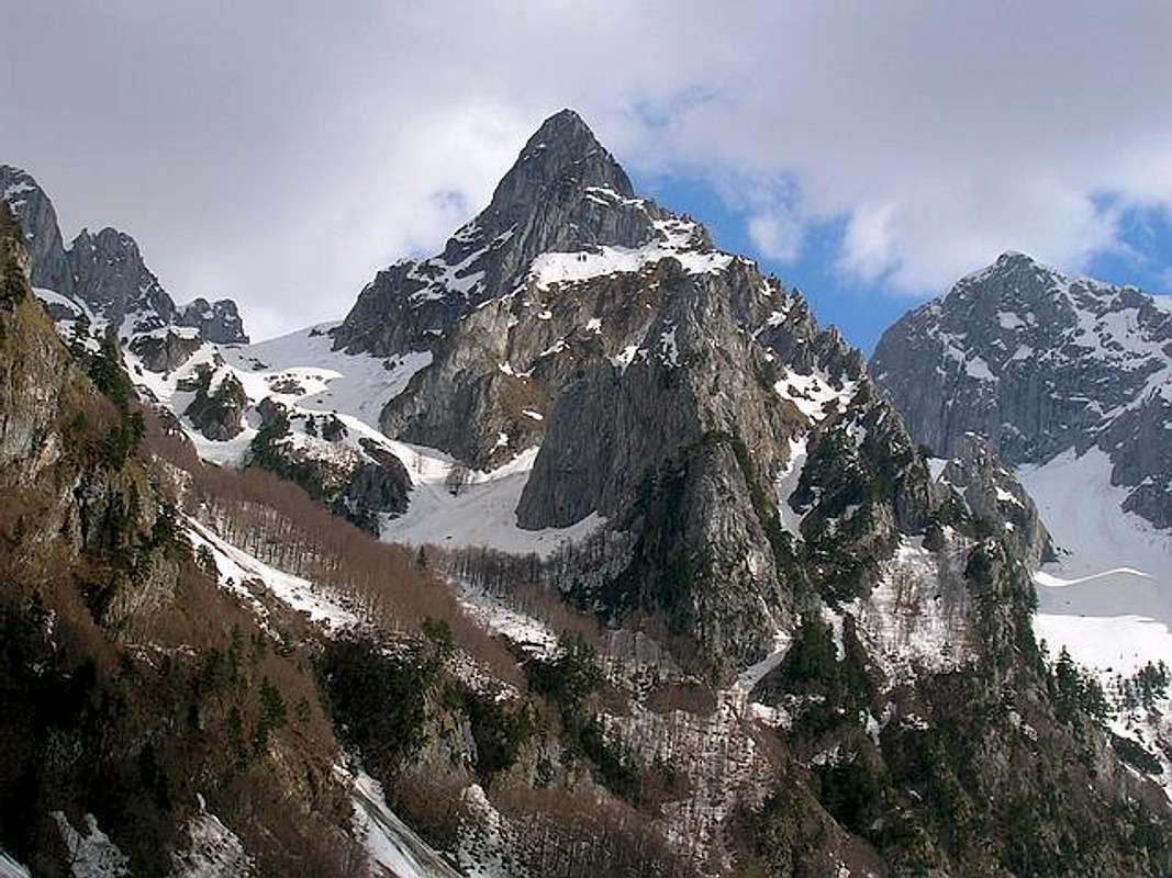
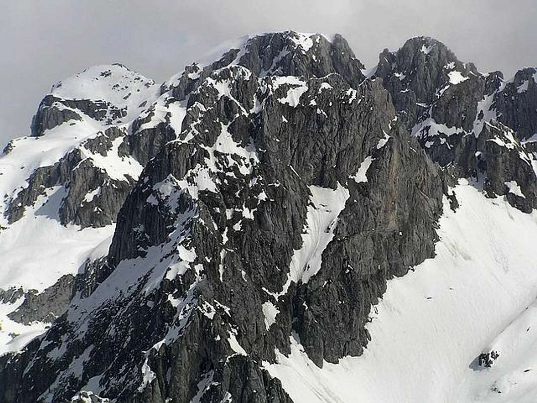
 Ocnjak peak from Volusnica summit
SUMMIT VIEW:
S: Maja Jezerce (2694 m), Maja Popluks (2569 m), Kokervhake (2508 m), Maja Ragomit (2472 m), Maja Alis (2422 m)
SW: Kolac (Kolata, 2528 m), Rosni Vrh (Maja Rosit, 2525 m), Maja Haruses (2424 m) and Maja e Pecmaras, Visitor (2211 m), Mt Bor, Gusinje town and Vusanje village
SW: Maja Snikut (Nikacki Vrh, 2554 m), Maja Skurt (2499 m), Karanfili (2460 m, 2490 m, 2441 m), Maja Lagojvet (2466 m), Maja Vukoces (2450 m), Forca (2340 m), Maja Grik e Halt (2625 m), Maja Radohines (2570 m), Maja Brijaset (Brijac, 2567 m), Maja Hekurave (2561 m), Majet e Zabores, Maja Malisores (2490 m), Maja Shchokishte (2461 m), Sev i Barde (2252 m)
N: Vojusa (Vojusit, 2210 m), Popadija (2057 m), Volusnica (1879 m)
E: Maja Desles (2403 m)
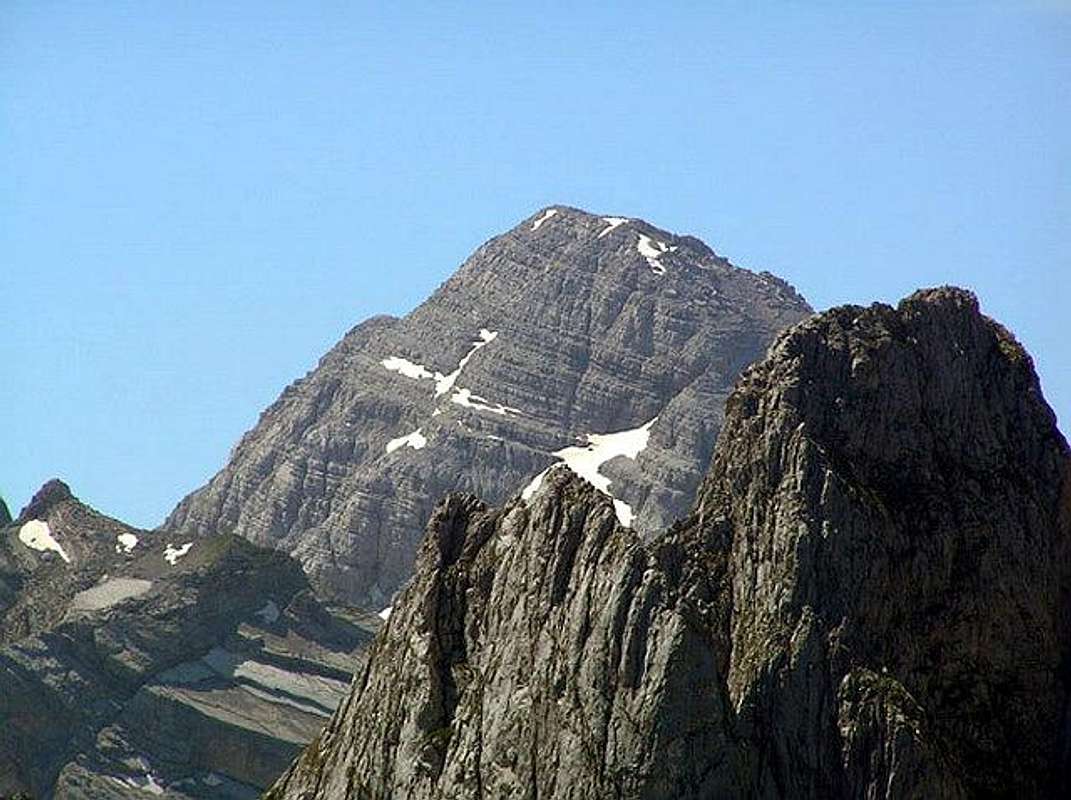
Maja Jezerce (2694 m) from Ocnjak (2185 m) summit
 |  |  |
Routes Overview
OCNJAK (2185 m):Route: Grbaja Hut (1132 m) - Ljubokuce Valley (1815 m) - Vidikovac - Ocnjak (2185 m): 3.30h
High difference: 1053 m
ROUTE DESCRIPTION:
Ocnjak climbing route start from Grbaja Hut in Grbaja Valley, from where route goes accross the Volusnica stream, on Granicarska Livada meadow and than to the left in Lukovaca Potok (1132 m) stream. The path continue about few hundred meters on small rocks and after that goes into forest. After forest path continue again on small rocks and again goes into forest. After 10 minutes the path exit from the forest and continute to the left in direction of Ocnjak massif. Than about 100 m easy ascent till marks which show that you must go right to the Ocnjak massif. Soon, you'll meat the end of the Dolina Ljubokuce (1815 m, Ljubokuche Valley) and also famous Vidikovac (Viewpoint), from where you can enjoy in amazing view to deep Grbaja Valley and also to Popadija, Volusnica, Karaula and Trojan peaks. From Vidikovac go up on small ridge till steep grassy plateau. From Vidikovac till here you'll spent about 30 min. Belowe this part of path is abyss and is recommendation that you need some mountaineering experience for this climbing route. After that path ascent till small saddle and goes to the left on plateau wide just 70 cm (0.7m)(above steep slopes of Krosnja), than on rocky part of the path to the summit.
 |  |  |  |
Getting There
Ocnjak & Severni Vrh Karanfila (Karanfil North Peak, 2460 m)
Gateway to Prokletije and Ocnjak (2185 m) peak are Plav town and Gusinje town and Grbaja Valley. Information how to get there:
By Plane
~To Beograd (Belgrade, Serbia&Montenegro capital) airport. Than with plane to Podgorica, capital of Montenegro, or with bus or car to Plav town.
~To Podgorica airport. Than with bus or car to Plav town and after to Gusinje town.
Information about flights & tickets find on the sites of JAT Airways, a former Yugoslav airlines, or on Montenegro Airlines.
By Bus
~Beograd (Belgrade)-Plav
~Podgorica-Plav
By train
~Beograd (Belgrade)-Bijelo Polje. Than with bus or with car (rent a car) to Plav and Gusinje.
By car
~Beograd (Belgrade)-Kraljevo-Novi Pazar-Plav-Gusinje.
~Podgorica-Kolasin-Andrijevica-Plav-Gusinje
Gusinje town and Plav town (in Montenegro) are the main destinations you would head first. In Gusinje you can buy everything (food, shampoo, soap, clothes,... and many other things), all what you need for few days of trekking and climbing in heart of Prokletije massif.
Gusinje - Grbaja valley: 7,5 km, (2 h of walking with big rucksack (backpack).
 |  |
When To Climb
View to Karanfili (2490 m) peaks from Ocnjak (2185 m) summit
If you're interested in backpacking/hiking/mountaineering/climbing, June - September are the best month to do so. In June and July also, you will find snow area on some places, specialy on north side of massif. Don't worry, snow is hard. If you will come earlier, take with you everything from mountain equipment (crampons, ice axe,...), which you will need for example in winter or spring time. Also, late summer and autumn offer a variety of fruit you will be easy picking while ascending some ridges like wild plums, raspberries and blueberries.
 |  |
Camping
Optimal place for stay and camping in the Montenegrin part of Prokletije range are "Branko Kotlajic" Hut and "Karanfili" Hut, both placed in Grbaja Valley. The owner of "Branko Kotlajic" Hut is "Radnicki" Mountain Club from Belgrade/Serbia). Exist possibility for getting a key of that hut and stay there. Information: e-mail: info@pd-radnicki.rs, www.pd-radnicki.rs . The owner of "Karanfili" Hut is "Karanfili" Mountain Club from Gusinje town.Exist chance to make a deal with shepherds who offer a place in their huts. Try it and let yourself be surprised. Most of the wayside restaurants can offer accomodations over night, you just have to ask "prenociste". Camping is not allowed but not controlled regularly.
Also, you can rent rooms in Plav and Gusinje towns and stay there. For orientation - from Gusinje till Grbaja valley is 7 km distance. By car - 10 minutes on asphalt road, by walk with big rucksack - 2 hours.
 |
Mountain Conditions
Sharp massif of Ocnjak from Volusnica (1879 m) summit
The best local weather forecast (4 times daily) for Prokletije (Plav town) on VREME YUBC NET
 |
Red Tape
No fees or extra fees for entering the Prokletije.No permits needed either.
Usual rules of behaviour for NP's do apply.
 |