
|
|
Mountain/Rock |
|---|---|
|
|
42.28000°N / 19.51000°E |
|
|
8281 ft / 2524 m |
|
|
Overview
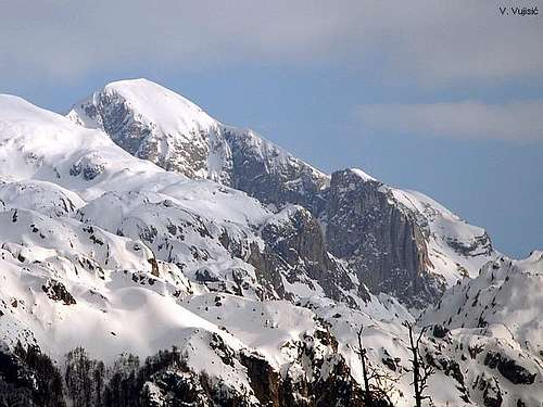 Winter outlook of Rosni Vrh - Maja Rosit (2524 m)
Maja Rosit (2524 m)(Rosni Vrh) is the highest peak of Mt Bjelic, which belong to most karstic part of Montenegrin Prokletije massif. Maja Rosit is 3rd highest peak of Montenegrin part of PROKLETIJE, behind Kolac (Maja Kolata) and it’s two peaks - Zla Kolata (2534 m) and Dobra Kolata (2528 m). Also, Maja Rosit is 3rd highest peak of Montenegro.
The summit of Maja Rosit (2524 m) is an extraordinary and maybe the best viewpoint of whole Prokletije massif. On the summit of this peak you can spend whole day in enjoyment in many impressive and amazing panoramas of Prokletije central massif. Unforgetable is view to , highest peak of whole Prokletije massif. Also, breathtaking is view to Valbona Valley and it's wildest, most impressive and most beautiful part.
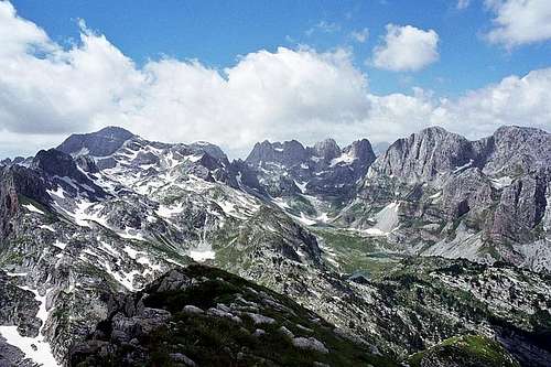 Incredible massif of PROKLETIJE range from Rosni Vrh - Maja Rosit (2524 m)
Finally, don't forget amazing view to giant massif of Majet e Zabores Group (Zabores e Krasnices) which is 13 km long! Whole this long and amazing massif can be seen from Maja Rosit summit! Between the peaks of Majet e Zabores Group specially dominates Maja Hekurave (2561 m), Maja Grik e Hapt (2625 m) with it's 500 m high & 300 m wide North Face, and Maja Briaset (2567 m) with it's 900 m high & 900 m wide impressive wall, one of the bigest in whole Prokletije massif. So, Maja Rosit - Rosni Vrh (2525 m) offer unforgetable enjoyment in many incredible panoramas of impressive Prokletije massif. Maja Rosit summit view means to be the privileged witness of Pure Paradise!
LOCATION:
Maja Rosit (2524 m) is placed on E from Maja Snikut (Nikacki Vrh, 2554 m), Maja Skurt (2499 m), Karanfili (2460 m, 2490 m, 2441 m), Maja Lagojvet (2466 m), Maja Vukoces (2450 m), Forca (2340 m), Vojusit (2210 m), Popadija (2057 m), Volusnica (1879 m), on W from two peaks of Maja Kolata (2534 m, 2528 m), Maja Desles (2403 m), Valbona Valley, on N from Maja Jezerce (2693 m), Maja Popluks (2569 m), Kokervhake (2508 m), Maja Ragomit (2472 m), Maja Alis (2422 m), on S from Visitor (2211 m), Mt Bor, Gusinje town and Vusanje village, on NE from Maja Grik e Halt (2625 m), Maja Radohines (2570 m), Maja Brijaset (Brijac, 2567 m), Maja Hekurave (2561 m), Majet e Zabores, Maja Malisores (2490 m), Maja Shchokishte (2461 m), Sev i Barde (2252 m), on NW from Maja Haruses (2424 m) and Maja e Pecmaras.
SUMMIT VIEW:
E: Maja Kolata (2534 m, 2528 m), Maja Desles (2403 m), Valbona Valley
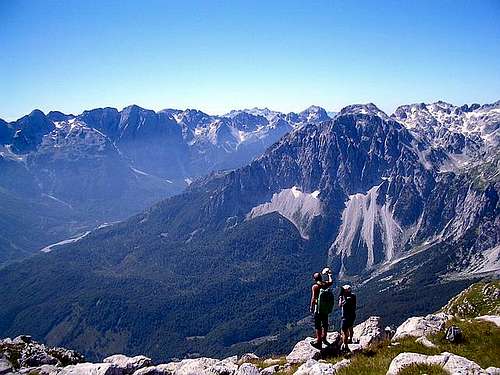
 Amazing Valbona Valley from Rosni Vrh - Maja Rosit (2524 m)
W: Maja Snikut (Nikacki Vrh, 2554 m), Maja Skurt (2499 m), Karanfili (2460 m, 2490 m, 2441 m), Maja Lagojvet (2466 m), Maja Vukoces (2450 m), Forca (2340 m
N: Visitor (2211 m), Mt Bor, Gusinje town and Vusanje village
S: Maja Jezerce (2694 m), Maja Popluks (2569 m), Kokervhake (2508 m), Maja Ragomit (2472 m), Maja Alis (2422 m)
SW: Maja Grik e Halt (2625 m), Maja Radohines (2570 m), Maja Brijaset (Brijac, 2567 m), Maja Hekurave (2561 m), Majet e Zabores, Maja Malisores (2490 m), Maja Shchokishte (2461 m), Sev i Barde (2252 m)
SE: Maja Haruses (2424 m), Maja e Pecmaras
 |  |  |
Routes Overview
Route: Gusinje - Vusanje (1060 m) - Roman katun (1900 m) (T4) 3.30h - Maja Rosit (2525 m) (T4) 2.30hHigh difference: 1465 m
Lenght: 9.5 km
Duration: 6h - 6.30h
DESCRIPTION OF ACCESS:
Access: From Vusanje (1060 m) village, cross the bridge and further along the flow of the Skakavica river to the katun (shepherd's hut) of Roman, where this mountain trail begins. After crossing the bridge turn right (west) for 50 meters to the Grlja gorge, a series of gigantic wreaths and waterfalls, made by the Skakavica creek. From there it continues underground and then emerges by waterfall to the Alipasini Izvori (springs). There it empties into the Vruja brook. From there, trek about 1.5 km and turn into the bushes, coming out at the karst foutain-head spring called Oko Skakavice (Cricket's Eye) or Savino Oko (1007 m) and Skakavica creek. The water is a transparent green, as if it were a crystal eye. After 1km from the spring go on foot along the Ropojana Valley, then turn left (east), up the wooded slopes of Mt Bjelic (read "Bjelich"). There the marked trail begins to the ascent towards the highest peak of Bjelic. The trail is hardly visible since it is rarely used. The rocks are also loose so extreme caution is mandatory. Pass through the Roman katun, that's in a little vale. This katun is no longer settled and has no water. They used to get water from melted snow. From Vusanje to this katun is about a 3.30 h by walk. Follow the ascent from the katun to the Cafa e Forumit Pass (2039 m). It is the border Of Montenegro with Albania, with a natural stone pyramid. On the left, towards the east the view opens onto the very steep grassy slopes of Maja Rosit (2525 m) summit. Maja Rosit is the highest section of the Mt Bjelic massif, which has a vast variety of terrain. There is also a very impressive view of Maja Jezerce (2694 m), Maja Brijaset (2567 m), beautiful Valbona Valley and the wreaths of the Albanian peaks of the Prokletije mountains.
 Incredible panorama of Prokletije massif from Rosni Vrh - Maja Rosit (2524 m)
Naturally, the whole horizon is surrounded by the other mountains of Karanfili (2460 m, 2490 m, 2441 m), Maja Kolata (2534 m, 2528 m), Visitor (2211 m), Komovi (2487 m) and others. Others parts of the Bjelic mountain massif are not climbed, due to their karst complexity, drought and unexplored areas. Maja Rosit summit is the loveliest, therefore duly represents this mountain massif which deserves to be analyzed and described in more detail. This tour is memorable, primarily because it leads to the closest visible touch of Mt Prokletije's summit as well as Maja Jezerce (Jezerski Vrh, Lakes Peak, 2694 m) that are located on Albanian territory. Naturally, this tour is part of the Montenegro - Albania border zone.
 |  |
Getting There
Gateway to Prokletije and Maja Rosit (2525 m) peak are Plav town and Gusinje town and then Vusanje village. Information how to get there:By Plane
~To Beograd (Belgrade, Serbia&Montenegro capital) airport. Than with plane to Podgorica, capital of Montenegro, or with bus or car to Plav town.
~To Podgorica airport. Than with bus or car to Plav town and after to Gusinje town.
Information about flights find on the sites of JAT Airways, a former Yugoslav airlines, or on Montenegro Airlines.
By Bus
~Beograd (Belgrade)-Plav
~Podgorica-Plav
By train
~Beograd (Belgrade)-Bijelo Polje. Than with bus or with car (rent a car) to Plav and Gusinje.
By car
~Beograd (Belgrade)-Kraljevo-Novi Pazar-Plav-Gusinje.
~Podgorica-Kolasin-Andrijevica-Plav-Gusinje
Gusinje town and Plav town (in Montenegro) are the main destinations you would head first. In Gusinje you can buy everything (food, shampoo, soap, clothes,... and many other things), all what you need for few days of trekking and climbing in heart of Prokletije massif.
From Gusinje town deeper in Prokletije massif till Vusanje (1060 m) village. Distance: Gusinje - Vusanje: 7,5 km, (2 h of walking with big rucksack (backpack).
 |  |  |
When To Climb
If you're interested in backpacking/hiking/mountaineering/climbing, June - September are the best period to do so. In June and July also, you will find snow area on some places, specialy on north side of massif. Don't worry, snow is hard. Like in many mountains, you will find full lakes from April till July. If you want to take a photos of lakes, better come in this period. Jun or July is the best for this. If you will come earlier, take with you everything from mountain equipment, which you will need for example in winter or spring time. Also, late summer and autumn offer a variety of fruit you will be easy picking while ascending some ridges like wild plums, raspberries and blueberries. |
Camping
Exist chance to make a deal with shepherds who offer a place in their huts. Try it and let yourself be surprised. Most of the wayside restaurants can offer accomodations over night, you just have to ask "prenociste". Camping is not allowed but not controlled regularly.Also, you can rent rooms in Plav & Gusinje towns and Vusanje village and stay there. For orientation - from Gusinje till Vusanje village is 7 km distance. By car - 10 minutes on asphalt road, by walk with big rucksack - 2 hours.
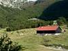
On the end of Ropojana Valley exist hut Ropojanski Zastan where you can stay before and after climbing of Maja Rosit (2525 m). That's the optimal camping place.
 |
Mountain Conditions
The best local weather forecast (4 times daily) for Prokletije (Plav town) on VREME YUBC NET |
Red Tape
You're in Montenegro-Albania border area and you must before your climbing of Maja Rosit peak just to contact the Border Security Department in Plav town. For the visit of certain (Albanian) parts of the range, where is highest peak of Prokletije massif - Jezerski Vrh/Maja Jezerce/Lakes Peak (2694 m) and beautiful Lakes Valley with few glacier lakes, you must get a special military permission in the Border Security Department in Plav town.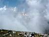 |