
-
 11495 Hits
-
 77.91% Score
-
 9 Votes
|
|
Mountain/Rock |
|---|---|
|
|
44.33560°N / 119.2426°W |
|
|
7060 ft / 2152 m |
|
|

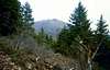
Moore Mountain is really not much more than a big bump (actually, a series of them) on the ridge of the Aldrich Mountains between Fields Peak and McClellan Mountain. It also sits on the ridge near the spot where the ridge from Moon Mountain intersects it. The north side is characterized by forests while the south side is mostly just low scrub. The Aldrich Mountains are named after Oliver Aldrich who was killed by Indians on the nearby mountain that now bears his name. The Aldrich Mountains also are part of the larger Blue Mountains.
Why climb Moore Mountain? Well, the question is really why not. The somewhat popular trail that links Fields and McClellan goes right around the base of Moore Mountain. If coming from the Fields Peak end of the McClellan Mountain Trail, you hike right past a wooden sign that identifies it as Moore Mountain. Whether Moore Mountain suffers from an identity crisis is not known but you may as well bag this one on your hike. There is no trail to the top, just head cross country to the highest point. If you are hiking in poor visibility you may be deceived into thinking you are at the summit though, just make sure you climb up to the top of 3 bumps to a small cairn at the summit. Views on clear days are great and include Strawberry Mountain to the east as well as the surrounding peaks of the Aldrich Range.
 |  |  |
Getting There
From Portland take Highway 26 about 233 miles to Dayville. Then continue on about 13 miles on 26 and turn right on Fields Creek Road at a sign for the Murderers Creek Guard Station. Go 8.2 miles to a sign for Fields Peak and Road 115. Turn left and go about a half mile to a "T" intersection. Turn right onto Road 2160 and proceed about 200 yards. Then turn left onto Road 041 and follow this rough steep road to its end at the trailhead for Fields Peak.
If coming from the east (Baker City, OR), take Highway 7 to Highway 26 and follow it about 18 miles west of John Day, OR to Fields Creek Road and proceed as above.
Red Tape
No fees or permits required.
When To Climb
Usually May to October but it would depend on road conditions above Highway 26.
Camping
The Billy Fields Campground is located on the Fields creek Road on the drive in. There are also camp spots at the trailhead as well as a tree-sheltered area I spotted just off the main ridge heading over to Moon Mountain (which would be just east and then north a hundred yards or so from Moore Mountain).
Mountain Conditions
Blue Mountain Ranger District
541-575-3000
Beware of rattlesnakes in warm weather. The off-trail characteristic of this peak as well as the many small scrub bushes and sagebrush provide excellent hiding spots for them.
Altitude ??
The height of this peak is just my best educated guess from looking at topo maps. There is literally no information out there on this peak so if anyone has any info that can accurately provide the height, please let me know.