
|
|
Mountain/Rock |
|---|---|
|
|
44.64990°N / 120.1519°W |
|
|
Wheeler |
|
|
Hiking, Scrambling |
|
|
Spring, Summer, Fall, Winter |
|
|
4694 ft / 1431 m |
|
|
Overview
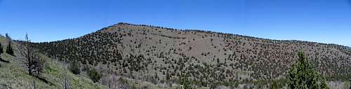
Sutton Mountain is a 4694-foot peak located about 10 miles north of Mitchell, Oregon. It forms part of the eastern backdrop of the Painted Hills unit of the John Day Fossil Beds. The view from the top includes the Painted Hills, the Cascades from Jefferson to Adams, and the rimrock filled John Day Country.
The base of Sutton Mountain is composed of the volcanic ash and pyroclastic flows of the John Day Formation and is capped by Picture Gorge Basalt that flowed from fissures near the town of Monument, Oregon about 16 million years ago. The John Day formation is the same formation in which the fossils of the John Day Fossil Beds and the colorful paleosols of the nearby Painted Hills are now preserved.
Vegetation is primarily juniper and sagebrush. During the spring, wildflowers bloom in the open meadows. If you are observant, you may see a few Simpson’s hedgehog cactus below the summit along the east ridge. This area provides habitat to pronghorn, deer, and elk.
An ascent of Sutton Mountain is a class 2 hike. Round trip distance is about 5 miles and can be done in a few hours. Elevation gain is about 1600 feet.
Sutton Mountain was named for an English immigrant named Al Sutton. Sutton was a stockman who emigrated to The Dalles in 1858, and moved to what is now Wheeler County in 1865.
Sutton Mountain is part of the 29, 000 acre Sutton Mountain Wilderness Study Area and is administered by the BLM. This area was recommended for future wilderness designation in 1996, though this has yet to come to fruition.

Getting There
To get to Sutton Mountain from the north, take Interstate 84 to Biggs Junction exit 104, and head south on US 97 ten miles to the Junction with OR 206. Head west on 206 through Wasco and continue for about 42 miles to Condon passing a wind farm on the way. At Condon, turn south onto OR 19 and continue 38 miles through Fossil to the Junction with OR 207 at Service Creek. Head south on OR 207 to milepost 15 and park on the left shoulder at a bend in the road, where there is a pull-off.To get to Sutton Mountain from the south or west, find your way to Prineville, OR. From Prineville, drive east on US 26 for about 48 miles. At a junction with OR 207, turn left. Follow this road about 10 miles to milepost 15 and park on the right at a bend in the road.
To get to Sutton Mountain from the east, follow US 26 to the same junction with OR 207, turn right and continue about 10 miles to the pull-off at milepost 15.
Red Tape
No fees or permits required.Camping
This is a short hike, so camping is not necessary, the three closest campgrounds areOchoco Divide, Muleshoe, and Service Creek
Conditions
Prineville BLM District Office(541) 416-6700 / email
3050 NE Third
Prineville, OR 97754 -900