
|
|
Mountain/Rock |
|---|---|
|
|
44.92370°N / 118.2323°W |
|
|
8525 ft / 2598 m |
|
|
Overview
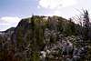
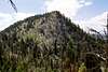
Peak 8525 is one of the more remote and lesser known peaks of the Elkhorn Mountains of northeast Oregon. It forms the head of four basins: Cunningham Creek to the southwest, Crawfish Creek to the northwest, Dutch Flat Creek to the northeast and the southeast ridge forms part of the source of the North Fork Powder River. It rises 2,700 feet above the North Fork John Day headwaters to the west and 1,800 feet above the meadows of Dutch Flat Creek to the east. The slopes are moderate to steep, with cliffs forming the cirque on the northeast aspect. Like all the Elkhorn’s northern summits, its formed of granite. See the Overview section of the Gunsight Mountain page for a good discussion of the geology of this area.There are two easy hikes to the summit from the 1611 trail. One is from Cunningham Saddle, which is a gap on the west ridge and the other is a longer, but less steep hike up the north ridge from Dutch Flat Saddle. It appears the northeast face can also be climbed, but this would be a very difficult scramble with some technical moves possible depending on the path chosen. The northwest aspect is forested, but the dense vegetation is tangled and the rocky surface steep and often wet from snow melt or springs. It wouldn’t be an easy hike. The southwest face is steep with a mosaic of open forest, grass, shrubs and rocks.
The terrain on the north and west ridges are easy to walk on, just requiring stepping over and around granite boulders. There are a couple areas that burned as spot fires from the huge forest fire that burned the North Fork John Day basin in the 1980s. This has resulted in tangles of dead trees in the burn areas that need to be avoided, but generally there is no problem.
 |  |  |  |  |
Getting There
Whether coming from the north or south on Interstate 84, take exit 285 at North Powder and head west on North Powder River Lane (county road 101) for 4.0 miles. Turn left on Ellis Road and continue for 0.6 mile to the junction with the Anthony Lakes Highway. Turn right on the Anthony Lakes Highway and continue for 15.7 miles to the left turnoff to Anthony Lake Campground. Continue for about 100 yards then take a right, following the signs to the day use parking, which is on the southwest corner of the lake.From the parking lot, head east along the south side of the lake on the Anthony Shoreline Trail, 1605. About where the trail meets a road on the east side of the lake a trail continues on east to Lilypad Lake and becomes the Elkhorn Crest Trail, 1611. Continue on this trail for almost a mile to where the trail splits. A sign will indicate the trail to the right goes to Black Lake. Go left (straight) and follow the trail above the east side of Black Lake and into the upper Antone Creek basin. Continue on through Angel Pass to Dutch Flat Saddle, which is about 3.5 miles from Anthony Lake. From here the north ridge can be hiked to the summit or another option is to continue on the main trail for another 0.75 mile to Cunningham Saddle for a shorter but steeper hike up the west ridge.
There are other approached to the mountain. A primitive road (7300-380) can get one into the North Fork John Day basin to Peavy Cabin, which is the trailhead for the Cunningham Basin trial. This is a three mile hike to Cunningham Saddle. Approaching from Dutch Flat is approximately a ten mile hike to the foot of the north ridge at Dutch Flat Saddle. Another approach is up the North Fork Powder River, but this requires driving on a poor road (7301) for several miles followed by a hike of several more miles via the Meadow Lake trail (1632), the Lost Lake trail (1621) and the Elkhorn Crest trail (1611) to Cunningham Saddle.
 |  |  |  |  |
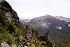
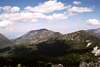
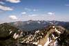
Views from the Summit
 |  |  |  |  |
Red Tape
There is no red tape other than standard wilderness regulations for people hiking from day use parking lot at Anthony Lake. But this is a long day hike covering approximately eight miles round trip. Persons backpacking in for extended stays should use the Elkhorn Crest trail parking lot, which turns left off the highway just before the Anthony Lake Campground turn. Use of this trailhead requires a Northwest Forest Pass, which cost $5 ($30/year) and can be purchased all all local Forest Service offices and at many area businesses.When To Climb
Most people climb the mountain from late July to October. The mountain would be very hard to access during the winter.Camping
There are developed campgrounds at or near the trailhead, namely Anthony Lake Campground where the hike begins. This campground can be very crowded and noisy at times. Smaller campgrounds very close to Anthony Lake are found at Grande Ronde Lake and Mud Lake.Black Lake is much quieter and there is at-large camping allowed basically anywhere. However, good back country camping along the Elkhorn Crest is limited due to topography. There is a small lake with good back country camping sites immediately southwest of Angel Pass. This would be opposite the head of the Crawfish basin from Pk 8525 and about a mile hike away. There are also many camping opportunities in Dutch Flat basin, particularly Dutch Flat Lake which is at the east foot of Dutch Flat Saddle and about a mile away by trail.
Lost Lake and the adjacent low basin northeast of Mount Ruth are about two miles away and might also be an option.
 |  |
Mountain Conditions
Current mountain conditions can be obtained from the US Forest Service:Baker Ranger District
3165 10th Street
Baker City, Oregon 97814
(541) 523-4476
NOAA Forcast