
-
 8896 Hits
-
 82.48% Score
-
 15 Votes
|
|
Mountain/Rock |
|---|---|
|
|
44.56314°N / 119.60322°W |
|
|
Hiking |
|
|
Spring, Summer, Fall, Winter |
|
|
4578 ft / 1395 m |
|
|
Overview

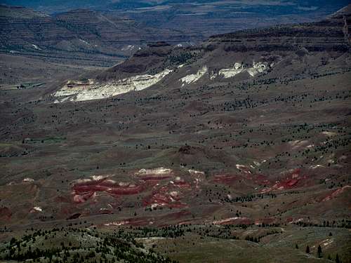
OK, let me get this out there right away. Save for the views of the Strawberry Range, the Aldrich Mountains and Lookout Mountain of the Ochocos (and supposedly there are views of the Cascades on a clear day), there is very little redeeming value in this mountain. Well, unless maybe you do this one in winter. Then, it might be an enjoyable experience. The views from the summit are indeed nice. Windy Point is located smack dab in the center of the state of Oregon in the John Day Fossil Beds National Monument (Sheep Rock Unit) and Sheep Rock pokes its head up over a nearby ridge and can be seen from the summit. Indeed, Windy Point is the backdrop of Sheep Rock from Highway 19. Windy Point is within the Ochoco Range of the Blue Mountains. Yeah, it looks like a neat place to be but I’ll get more into the other side of that.

Located near the Painted Hills area, I will admit this truly is an amazing scenic spot in Oregon, and that is saying something as this is a state full of them. Views from this hike also catch glimpses into areas eroding away to show the striped orange and red rocks along with the blues and greens. If only you didn’t have to put up with the other stuff from this place….

What am I talking about? Well, this is the high desert. It is cattle country like from the old Western movies. There are lots and lots of rocky and weedy areas. What this adds up to is a high concentration of rattlesnakes and ticks in this "lovely" place. On our hike (my dog accompanied me), we startled 3 rattlesnakes in open rocky areas on the ascent. There is nothing like that rattle sound inches from your ankles to get your heart pumping. Or, like seeing your dog nose closer to it to see what it is. If you go, and it is warm, you will see/hear rattlesnakes and need to be prepared as such. (Don’t ask me how to be prepared, I spent the morning batting every rock and weed clump with my trekking pole after hearing the first one and still almost stepped on two more. Do some research so you wear the right shoes, clothes or whatever else you need to do so you don’t get bitten. Know what to do if you get bitten. And I would strongly suggest not taking dogs, kids, or people freaked out by snakes here.) Not wanting to take the same route down from the summit, we hiked along an old jeep road across weedy meadows. This means ticks. Lots and lots of bloodsucking, disease-spreading, no-reason-to-exist ticks. Use DEET, permethrin, voodoo charms, whatever it takes if you go here when ticks are active. I pulled the f’ers off my dog for a week before finally taking her in to the vet to be “cleansed.” Between the two of us, we had about 40 of ‘em on us. Poor Luna had the vast majority of those.
Barbara Bond in her 75 Scrambles in Oregon book lists this as a scramble but that is only because she makes her route include a small nearby mountain called Middle Mountain where you may have to use a hand or two to move between some basalt rock bands. Her route also includes a southward hike from the summit down near “Hole In The Ground” (not the larger more well-known one near Crater Lake, this is another much smaller one) with a descent through some rocky areas around Sheep Rock (also supposed to be full of rattlesnakes). Windy Point itself is a hike, unless you purposely climb around on some of the rock bands near the summit.
So, views=yes. Pretty nice ones too. Whether it is worth it would be your call. As for me, I would not return to this place to hike unless it is in the cold of winter when varmints and parasites are dormant. Maybe when it is cold and gloomy in the Willamette Valley in February and it’s been 30 days with no sun, the goopy hoof prints from cattle are hardened and won’t pull your shoe off, then maybe this one might be appealing. Until then, just be glad I went there first for you all and can give you fair warning.
Getting There

Being in the middle of Oregon, you can come to Windy Point a number of ways.
From Portland, you have two options, each takes about the same amount of time. You can take I-84 east through the Columbia River Gorge to Biggs, OR and then take 97 south to Wasco where you will take 206 down to Condon, OR. From Condon, you will take a right on the main drag and pick up Highway 19 south to Fossil. About 21 miles south of Fossil, you continue on 19 left at a junction going through Spray and Kimberly. As you continue traveling south on Highway 19, when you cross Dick Creek, start watching for the bridge that crosses the John Day River (which is on your right at this point). When you cross the bridge and the John Day River is on your left (this bridge is currently under construction as of June 2011 and nearing completion), you will want to immediately look for the one car pullout on your left. Park here. It is highly unlikely anyone else will be hiking this, but in the event someone is you can park on the side of the road further south.
Likewise, from Portland, you can take Highway 26 through the mountains near Mt. Hood, through Madras, past Prineville and Mitchell to Highway 19 just west of Dayville, OR. Turn north (left ) on Highway 19 and proceed just a few miles north to the same spot.
From the east (LaGrande, Ontario) you would probably just want to take Highway 26 west pat Dayville to Highway 19 and proceed as above.
From the northwest (Hermiston/Pendleton), my guess is the best way would be to take 395 south to Mount Vernon where you pick up Highway 26 and proceed west to Highway 19.
Red Tape
There current is no red tape to hike this. It is public land, there are no fees or permits required. The only hassle will be parking as there really is only one spot in a pullout near the bridge. There is room along the road as you head south though, still walking distance but no set parking lot.Please note though that since this is within the John Day Fossil Beds National Monument, picking flowers or removing fossils or other materials is not allowed.

Camping
Mitchell City Park (3 RV hookups too! Woo hoo!) 541-462-3121Spray River Front Park - about 25 miles north on Highway 19, has 8 primitive campsites, no hook-ups, $12 per night
Camping in the John Day Basin information
Ochoco National Forest Campgrounds
When to Climb

Can be done year round, see the overview above for why I would suggest doing this one when it is colder. I hiked this in February and June. February wins hands down! This area does not get that much snow in the winter but even if it did, I think it would still be fine and enjoyable. You are able to see the summit from the parking area so you can tell if you may need snowshoes or not. Although I doubt that would ever be the case. There is no water on the hike though.
Mountain Conditions
John Day Fossil Beds National Monument Visitor Center (Nearby, can call for conditions.)
USDA Forest Service page