
|
|
Mountain/Rock |
|---|---|
|
|
37.69470°N / 107.6357°W |
|
|
San Juan |
|
|
13074 ft / 3985 m |
|
|
Mount Garfield Overview
 Mount Garfield
Mount Garfield is the westernmost peak in the San Juan Mountains' spectacular Grenadier Range. Colorado's 591st tallest mountain is assuredly among the least visited thirteeners in the state. It is rugged and remote even from a high camp in Vestal Creek. The peak features an exciting third-class ridge route and a complicated approach requiring a snow climb before leading you into two pristine, isolated basins, one of which holds lovely Garfield Lake. Because the approach to Mount Garfield is so involved, many people try to maximize their efforts by attempting to summit all four peaks at the west end of the Grenadiers – Graystone Peak, Electric Peak, Point Pun, and Garfield – in a single, long day. If you're interested in these peaks, please refer to Robert Rosebrough's excellent guidebook Climbing Colorado's San Juan Mountains.
All of this aside, however, the peak's defining feature has to be its fantastic rise from the Animas River. In little more than a single horizontal mile, Mount Garfield's west slopes shoot skyward nearly 4400 vertical feet. Indeed, the peak's vertical relief is among the most dramatic in Colorado, and this fact bears itself out statistically. Garfield ranks as the 21st most impressive in the state using a method devised by David Metzler that he calls "spire measure." Here's a link to the top 50 Colorado peaks ranked by spire measure.
Grenadier Range Overview
Sweeping faces of two billion year-old quartzite in a remote wilderness setting make the Grenadier Range one of the most intriguing locales in Colorado. Combined with the Needle Mountains to the immediate south, they make up the hardened core of the otherwise volcanic San Juans. The Grenadiers and Needles are the only places in the San Juans where the basement rock withstood the range's period of vulcanism. Therefore, the history of the Grenadiers is an interesting one.The Grenadiers were originally uplifted 70 million years ago as part of the enormous San Juan Dome during the Laramide Orogeny, the mountain-building episode responsible for the creation of most of Colorado's peaks. By around 35 million years ago, the San Juan Dome had eroded into an undulating but mostly level surface. Mostly level except for the nascent Grenadiers and Needles, that is. During the San Juans' period of volcanic activity, nearly the entire surface was buried in layer after layer of lava and ash flows, but the volcanic flows would only lap at the Grenadiers' and Needles' feet. The Grenadiers, as Hopkins and Hopkins put it, "remained intact during the San Juans' explosive formation to become a magnificent range of glacially carved metamorphic basement rock." The Grenadier Range is actually just the spiny crest, the only part that extrudes to such inspiring heights, of the huge Grenadier fault block, which reaches for hundreds of miles northwest into Utah and southeast all the way into Oklahoma.
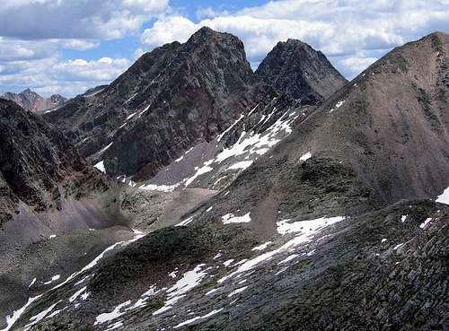 Arrow & Vestal Peaks
Basement rock, hard quartzite faces... what does all this mean to you as a climber? It means the Grenadiers feature "the highest concentration of quality rock climbs in the San Juans," according to Robert Rosebrough. The Grenadiers are highlighted by eight of Colorado's highest 200 peaks, and Vestal Peak, the sole representative from the highest 100, is the monarch. The range trends northwest to southeast for eight short but glorious miles between the Animas River and Vallecito Creek across the northwestern corner of the Weminuche Wilderness. The area saw a relative dearth of mining activity, so there are no maintained trails leading into the key drainages on the range's north side: Vestal Creek and Trinity Creek.
The ridge that divides Trinity Creek and Vestal Creek forms a convenient way to distinguish the eastern portion of the range from the west. On the west we have perhaps the more remarkable section. The arcing north faces of Arrow, Vestal, and Trinity Peaks seem like impossible copies of one another. The most impressive of these faces is the famed Wham Ridge of Vestal Peak, one of Colorado's classic climbs. The western end of the range is anchored by a collection of peaks – Electric Peak, Graystone Peak, Point Pun, and Mount Garfield – that encircles beautiful Garfield Lake. Their remote position and their lower summit elevations make these among the least frequently climbed thirteeners in the state.
The eastern end of the range includes three high thirteeners: Storm King Peak, Mount Silex, and the bastion peak, The Guardian. These three peaks brandish steep 1500' north faces. Just south of these three are two shorter but equally rugged thirteeners, Peak Eight and Peak Nine. Some call Peak Nine one of the most difficult thirteeners in the state to climb by its easiest route.
The Grenadier Range is one of the few places in the San Juans that were not climbed by either the Hayden or Wheeler Surveys. Franklin Rhoda's notes from the Hayden team's climb of Mount Sneffels show how the Grenadiers were nevertheless on the survey teams' minds as they traveled through the region: "The group of quartzite peaks stood out as boldly as ever about thirty miles to the southeast. In fact, I may state here that we have never yet seen a group from any station (and we have viewed it from all sides) without feeling both deep respect and awe for their terrible ruggedness. The fact... that the storm clouds seem to hover about them before starting on their meandering ways only served to add to our feelings of uneasiness."
The first climbers to challenge the Grenadiers' heights were William S. Cooper and John Hubbard in 1908. The range had caught Cooper's eye from the summit of Pigeon Peak. The pair camped at Balsam Lake and hiked to the saddle between Vestal and Arrow. They climbed up both peaks by gully routes on their respective south faces, finding Vestal to be an interesting but straightforward climb.On the other hand, "Arrow Peak," Cooper wrote, "proved to be really difficult. Several times our holds depended on the strength of our fingers." The range saw no more climbers until 24 years had passed when Carleton Long and John E. Nelson climbed Vestal and Arrow and made a first ascent of Point Pun. They are also credited with naming Wham Ridge. After studying Wham's impressive profile from the summit of Arrow Peak for a few minutes, Nelson exclaimed, "I still don't believe it!"
Getting There
The most common route to get to Mount Garfield is via the Elk Creek Trail. If you have the time and money, you can ride the Durango-Silverton Narrow Gauge Railroad (970-247-2733) to the train-stop in Elk Park. If you choose to ride the train in from Silverton, you'll need to be quick during your backpack in due to the train's afternoon arrival in Elk Park. Be warned, the unmaintained Vestal Creek Trail will slow even the heartiest of backpackers!Most parties will choose to backpack in from the Molas Pass Trailhead, however, which is located at a signed turnoff five miles south on US-550 from the town of Silverton. This alternate approach adds about 6.5 miles to your round trip, and requires a 1600' climb out of the Animas River canyon during your return trip. While this is a tiring finale to a trip to Vestal Creek, this is a section of the Colorado Trail, and it includes numerous switchbacks so backpackers can gain elevation at a steady and sustainable pace. The one-way distance to Vestal Creek from Molas Pass is approximately 8 miles and requires 2600' of elevation gain from the Animas.
From the Molas Pass Trailhead, follow the signs and descend 1600' to the Animas River and Elk Park. Once you cross the excellent footbridge over the river, start hiking along the DSNGRR's tracks. You shouldn't stay alongside the railroad tracks very long at all, though. Watch to the left, and find the signed turnoff for the Colorado Trail. After hiking a half-mile on this spur trail, you'll pass a wilderness boundary sign and join the Elk Creek Trail. Continue your backpack for three miles to the notable beaver ponds at 10,000' and a glorious view of Arrow Peak. Walk around the west side of the ponds on some talus and find a trail that descends to Elk Creek. It's worth it to find this trail because it will lead you to a suitable log-crossing of the creek and to the Vestal Creek Trail.
This map may assist in your progress from this point forward. The Vestal Creek Trail is unmaintained with a lot of deadfall to impede your progress. But it's far preferable to a bushwhack up very steep terrain. Hike up the strenuous trail and enter a small meadow at 11,000' where the creek hooks to the east. Stay on the trail and enter the trees once more. The first good campsites are available in this patch of forest once you reach flatter terrain. Otherwise, continue through the trees and hike through a second meadow found at around 11,400'. This meadow is situated below Vestal and Arrow Peaks, and there's a fine campsite atop a rocky bench on the north side of the meadow. You can continue to the next patch of forest where another couple hundred feet of elevation gain will lead you to a group of large campsites, your last good opportunity to drop your bags and set up camp.
Red Tape
Mount Garfield is located in the Weminuche Wilderness, and typical wilderness restrictions apply. Contacting the managing agencies (see 'Mountain Conditions') is the surest way to get up-to-date information. Campfires are not allowed in Vestal Creek. Stoves only!Leave No Trace suggests you observe these principles when traveling and camping in all public lands, especially wilderness:
1. Plan Ahead and Prepare
2. Travel and Camp on Durable Surfaces
3. Dispose of Waste Properly
4. Leave What You Find
5. Minimize Campfire Impacts
6. Respect Wildlife
7. Be Considerate of Other Visitors
When To Climb
Mount Garfield is typically climbed from late June to mid-September. In early summer, be prepared for spring season snow in the couloir to reach the Graystone Basin and Graystone's north slopes. Before June, the snowpack below treeline would make the approach an exhausting and potentially prohibitive one. Climbs later in the year are possible, but this varies year to year with the arrival of autumn snows.Camping
Camping is permitted in the Weminuche Wilderness. Remember, you find a camping spot, you don't make one. Help sustain water purity by camping away from creeks and lakes. Sparse but available camping is can be found from around 11,200' in Vestal Creek to around 11,600'. Please refer to this map for more information.Mountain Conditions
Forest Service ranger districts and local outfitters are your best bet for gathering information on current snow conditions and other information. The Columbine Ranger District (970-247-4814) is responsible for the Weminuche Wilderness near Silverton. Southwest Adventures of Durango (1-800-642-5389) is a great resource, as well.For weather information, the National Weather Service is a good place to start:
Mount Garfield NWS Experimental Point forecast
Sources
Donald L. Baars, The American Alps: The San Juan Mountains of Southwest ColoradoRalph Lee Hopkins and Lindy Birkel Hopkins, Hiking Colorado's Geology
Randy Jacobs and Robert M. Ormes, Guide to the Colorado Mountains
Gerry Roach, Colorado's Thirteeners: 13,800 to 13,999 Feet
Robert F. Rosebrough, The San Juan Mountains: A Climbing and Hiking Guide