
-
 14449 Hits
-
 89.39% Score
-
 29 Votes
|
|
Mountain/Rock |
|---|---|
|
|
37.76560°N / 107.6054°W |
|
|
San Juan |
|
|
Hiking |
|
|
Spring, Summer, Fall, Winter |
|
|
13402 ft / 4085 m |
|
|
Overview
 Mountain Men on Mount Rhoda
Mount Rhoda is an interesting San Juan Thirteener topped by a blocky rock protrusion. From vantage points to the north, Mount Rhoda has a distinctive rectangle of rock capping its summit. The dark rocky summit turret is colored by bright orange lichen. Like many peaks in the immediate area, Mount Rhoda appears gentle from the west and the south only to reveal much more rugged and dramatic eastern and northern aspects.
Mount Rhoda collaborates with neighbor UN 13434 to form the imposing western headwall of the lovely and dramatic Spencer Basin. Gentle and green from the south and the west, Rhoda’s ruggedly graceful north face suggests a steep, intimidating, black rock beast above. Mount Rhoda provides the visitors with fantastic views in all directions, but the most captivating are those to the south of the bold and sinuous Grenadier Range.
Rank: 319th highest peak in Colorado
Prominence: 302 feet
USGS Quad: Howardsville
Trails Illustrated Map: #140 Weminuche Wilderness
Rank and Prominence Information: Lists of John
About This Peak's Name
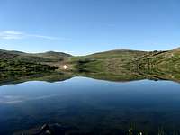 Highland Mary Reflection Highland Mary ReflectionChicagoTransplant | Special thanks to SummitPost member ChicagoTransplant for this interesting information: Mount Rhoda is named for Franklin Rhoda. A member of the Hayden Survey and a pioneer in early San Juan mountaineering, Mr. Rhoda was on the first ascent teams for Mount Sneffels, Mount Wilson, Uncompahgre, Handies, San Luis and Sunshine. These first ascents all took place in 1874, most with A.D. Wilson (the one the two 14ers are named for). Rhoda also authored "Report on the Topography of the San Juan Country" which is contained within the Hayden Survey's volume "Bulletin of the United States Geological and Geographical Survey of the Territories (US)". |  Mount Rhoda Slopes Mount Rhoda SlopesChicagoTransplant |
Getting There
 South Ridge of Mount Rhoda
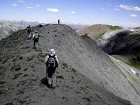 Mount Rhoda's Northern Ridge
Eastern Approach
Mount Rhoda can be accessed via Cunningham Gulch outside of Silverton. To get there, take Highway 110 (Green Street) north out of Silverton. Continue north through the town toward Howardsville. Turn east/right on San Juan County Road 4 toward Stony Pass (you may note the signs to the Old Hundred Mine tour). Turn right to leave the Stony Pass road and drive up to the end of Cunningham Gulch to the trailhead. High clearance is recommended to reach the actual trailhead at the end of the road. Be sure to look for a left turn off of this road that crosses Cunningham Creek just before reaching the parking area. If the road starts switchbacking, you've gone too far. The parking area should be visible on the left and below.
Western Approach
This peak can also be accessed via Deer Park. To reach the Deer Park trail, use the Kendall Mountain Trailhead in Silverton at the intersection of 14th Street and San Juan County Road 33.
 Rhoda from south ridge of UN 13434
Camping & Lodging
 Morning alpenglow on Whitehead Peak, Mt Rhoda and PT 13343.
By chicagotransplant
 SSW from Mount Rhoda
 UN 13434 from Mount Rhoda
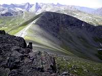 Whitehead Peak from Mount Rhoda
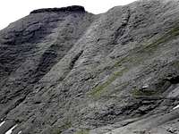 Rugged north face of Mount Rhoda
Established National Forest Campgrounds
The South Mineral Campground is about 6 miles from Silverton. The campground has 26 sites, available on a first-come, first-served basis. At 9,800 feet elevation, even summer nights will be chilly. To get there, drive two miles west of Silverton to Forest Road 585. Follow FR 585 west along the creek for four miles to the campground entrance. The facilities provide picnic tables, composting vault toilets, fire grates, trash disposal and potable water.
San Juan National Forest campground map
Trailhead Camping
There is rustic camping near the trailhead for Highland Mary Lakes / Cunningham Gulch.
Commercial Campgrounds
Silverton hosts at least three commercial campgrounds offering services such as RV hookup, snacks and showers. These include Silverton Lakes Camper Park, Silver Summit RV Park and Red Mountain RV Park. Additional RV parks can be found by visiting the Silverton Magazine online lodging guide.
Cabins, Cottages, Hotels and Bed & Breakfasts
The lodging in and around Silverton could be described as “limited” and “eclectic”. Many are family owned and operated and tend toward the friendly and cozy, versus the sophisticated or luxurious. The Silverton Magazine provides a good online lodging guide.
Weather & Seasons
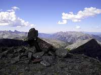
 Atop the summit turret
 Ascending the south ridge
Summer in the San Juans is heavenly, with warm sunny days and cool, crisp nights. Mid-summer wildflowers will knock your socks off. As with the other mountainous areas of Colorado, the afternoon thunderstorms mean summertime hikers need to leave the summit by noon. The San Juans are well-known for thawing out later than other parts of Colorado; it is not uncommon for an ice axe to be required year-round on certain routes.
The town of Silverton and surrounding mountains receive massive amounts of snowfall in the winter months. Avalanche chutes abound in the area; in the summer, the wounds from the previous snow-season’s avalanche activity are evident. Exercise prudent snow sense in these mountains when snow cover is present.
 Nearing Mount Rhoda summit turret
Red Tape
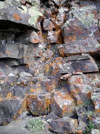 Lichen on Mount Rhoda
 Photo by Tonka
There is little or no red tape in this part of the National Forest.