
|
|
Mountain/Rock |
|---|---|
|
|
42.13855°N / 113.12454°W |
|
|
Cassia |
|
|
Hiking |
|
|
Spring, Summer, Fall |
|
|
9395 ft / 2864 m |
|
|

Overview
The Black Pine mountain range is a beautiful range in the southeastern corner of Cassia county, found in southern Idaho, not far from the Utah border. Very obvious from I-84, this range has always enticed me to want to walk among the high ridgeline that I could see as I made the drive from Burley to Salt Lake City so many times. The range has peaks that are about the same elevation but this page is going to be dedicated to just one of them, Black Peak. Black Peak is the highest peak in the Black Pine mountain range by just a few feet over nearby range namesake, Black Pine Peak. Normally I would visit both peaks on the same visit but when I found out that I had a narrow weather window, I chose Black Peak as my logical goal. Black Pine Peak has a communications structure on its summit and Black Peak is the bearer of the USGS benchmark and is just a few feet higher than Black Pine Peak. In researching the peak, I have found two elevations listed for it, one as 9395 feet high and another as 9389 feet high and a third agrees with the 9395 height. Even the topo has a different height listed. Confuaion about the designation of Black Peak being higher is caused by the topo map which lists Black Pine Peak as one foot higher. However, the benchmark elevation used for Black Peak on the topo map is ten feet lower than the actual highest spot. That is why I feel that Black Peak is 9 feet higher than Black Pine peak. Lists of John has Black Pine Peak as the highest point while Peakbagger.com has Black Peak listed as the Black Pine range HP. So to avoid the confusion, I'd recommend that you go to each summit "just in case".Interestingly enough, Black Peak is the 8th most prominent peak in all of Idaho (see this list) with over 4000 feet of prominence. It is the 129th most prominent peak in the lower USA with that amount of prominence (see this list) For more information on the topic of prominence, go to this website.
I-84 is located just a few miles to the east and parallels the range for much of its length. An excellent Idaho Mountain book written by Tom Lopez called "Idaho: A Climbing Guide" states that this range is "the most distinctly defined mountain range in Idaho. It is surrounded by wide valleys, and rises steeply on all sides." It runs in a north-south direction for 17 miles and offers spectacular views of the Great Salt Lake in Utah. The range is seldom visited by hikers and climbers. The highest mountain in the range is Black Peak at 9,395 ft. Black Pine peak is only 10 feet shorter at 9,385 and is a little more than a mile away from Black Peak. There are no other peaks above 9,000 ft. in this range but the other major peaks are all at about 8,000 ft."
Getting There
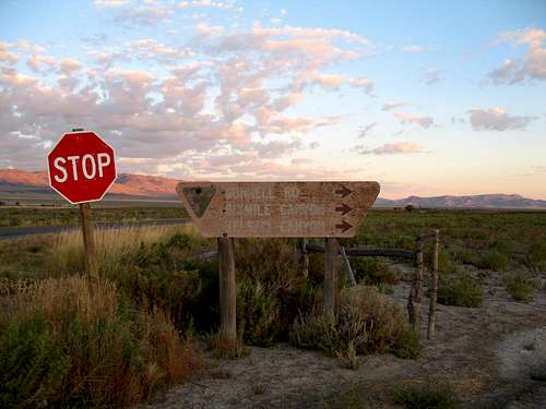
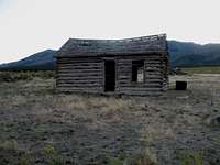
From the west:From I-84 as you head north, take exit 228 which puts you on highway 81, heading for Malta. If coming from Salt Lake, you could take exit 245 at Sublett and head west on Sublett Road until you reach highway 81 just north of Malta. After reaching Malta, head about 13 miles south on Highway 81 watching closely for the turnoff for Six Mile canyon. Turn east onto the signed Sixmile Canyon Road and follow the well graded dirt/gravel road east for about 5 1/2 miles to a junction where the road hits a gate (marked as "no trespassing") Even if this gate is open, take the road that goes south and you will immediately see a faded sign with arrows pointing south to Sixmile Canyon, Kelsaw Canyon, and Strevell. Head south on this dirt road for about 3/4ths of a mile and turn east onto a road located just before a corral. There was a gate but it was open. Follow this road east toward the mountains. The road takes a left turn at 1 mile, and then passes 2 old cabins and turns right at 1.25 miles. You will pass a forest service sign and at 1.7 miles, a road coming in from the northwest will join the road you are on and then you will enter the canyon. At 2.7 miles, you pass Sixmile Reservoir which will be on your right. At 3.3 miles, keep left at a junction and drive as far as you can. See Dan Robbins trip report for the information that we used to utilize the route from the west.

From the east:
John Vitz provided this information from his 2007 trip and I share some of it below:.
"For the east side approach (Pole Canyon), exit I-84 at the Juniper exit, and take the west side frontage road south about .7 miles to a road heading west. These roads are now in the middle of some rancher's fields. Go west into the forest about 7 miles to Pole Canyon Spring. About 0.1 mile past the spring a trail starts on your left. It is not easy to see. There is a sign, also not easy to see, on a tree denoting the trail." John hiked up via this trail which he stated was
"well graded but somewhat overgrown trail for about 2 miles to the saddle at the head of Pole Canyon" He then utilized "use trails" over the top of War Eagle Peak and continued over and/or around a bump, then Black Pine Peak and then a few more bumps to the top of Black Peak.
 On the road in
 Red Tape
The range is located in the Sawtooth National forest but is surrounded by BLM land and private property. Most of the private property is well signed for "no trespassing" so be aware of where you are.Sawtooth National Forest
2647 Kimberly Rd. E.
Twin Falls, ID. 83301
(208) 737-3200
 Summit cairn
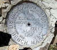 Summit benchmark
Camping
No official campgrounds exist in the immediate area but about twenty miles to the south, just across the Utah border is a forest service campground called Clear Creek Campground. It has 8 spaces and is located at the base of Bull Mountain. It has decent campsites and vault toilets. A creek runs through the campground and was running when I visited there for two days in mid September.This link has more information on this quiet campground
Weather

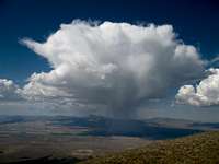 Pay attention to changes
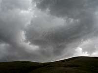 Demonstating the need to drop elevation quickly
Route
The best way to describe this hike is that it is mainly cross country. Choosing the correct line makes a big difference as there is an easy way and a harder way. The harder way consists of steep vertical brush and slows you down whereas the easy way has much less brush to contend with. We found an easier way on the way down which wasn't a bushbash and I did take GPS waypoints during the descent and have marked them with yellow diamonds on a map which shows both the ascent route we took and the easier descent route.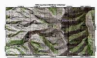 our routes
We parked at this spot: GPS 42.1284 -113.1552 Elev 6200'
I've posted a map that shows
Round trip was seven miles and the elevation gain was 3200 feet.
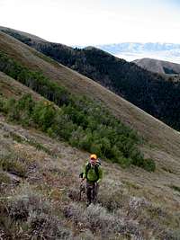 On the way up
  Vertical brush
  our route up
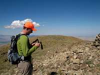 Rob at the summit
 Heading down
 Summit views
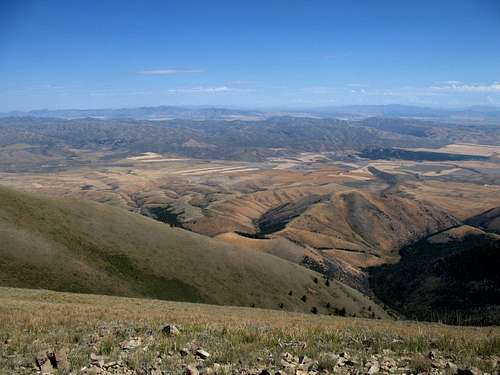 Looking east
 Looking south
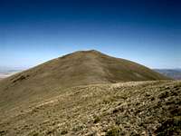 Black Peak