
|
|
Mountain/Rock |
|---|---|
|
|
43.09340°N / 111.3115°W |
|
|
Bonneville |
|
|
Hiking |
|
|
Summer, Fall |
|
|
9803 ft / 2988 m |
|
|
Mtybumpo's fine pic
Overview
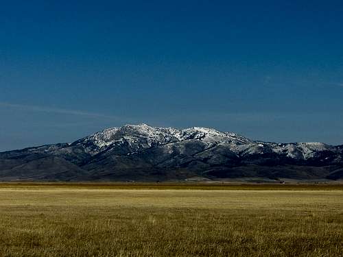
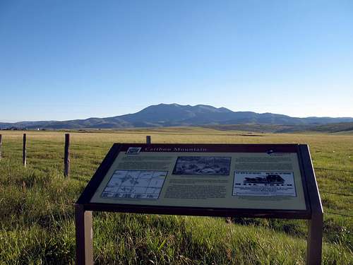
This mountain is to be found in Southeastern Idaho and is the dominant mountain seen east of the Grays Lake National Wildlife refuge. As noted in the link about Grays Lake, "Caribou Mountain, the second highest mountain in southeastern Idaho (elev. 9803 feet), provides a picturesque backdrop to the refuge." Even more information on the Wildlife refuge can be found here and I'd like to quote from this link: "The refuge hosts a large nesting population of greater sandhill cranes; as many as 1200 individuals are counted in the valley during migration and staging times. The refuge is a birding destination, and a good area to view the rare trumpeter swans. This near-pristine montane wetland is being threatened by the same type of suburban/rural development that has so heavily impacted nearby Jackson Hole." So, be aware of the special area that is close by when you visit Caribou Mountain.
What gets most peakbaggers interested in this one is the 3093 feet of prominence which is enough to claim 29th place in the top 100 prominence peaks in Idaho. Lacking only a couple hundred feet of height to garner it a ten thousand footer ranking, Caribou Mountain is a beautiful mountain, worthy of a visit if you can find your way to it. Getting to it is the trick.
As already mentioned, this mountain is just to the east of Grays Lake National Wildlife refuge and its height makes it the highest mountain in the Caribou mountain range. The major complaint voiced by those who have visited this mountain is centered on bugs. Lots and lots of bugs although I found the mosquito population tolerable when I was there in mid August but just barely. Despite its name, there are no caribou to be found on this mountain or even in the overall area. This mountain was named after a man who was called "Cariboo Jack" by his friends and More information about "Cariboo Jack" is provided in the History section below.
Getting There

| 
| 
|
There are different ways to get there, one from Idaho Falls, another from Soda Springs and yet one more way from US 89 to the east.
From Soda Springs:
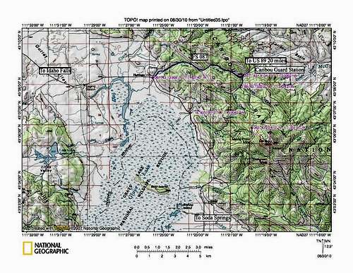
Take Highway 34 north from Soda Spring about 27 miles to the Grays Lake turn- off. Stop at the information signs that give a history of the Cutoff and of Caribou Mountain that are located not far north from the turn off. From here head north, first on pavement and then on a good gravel road to Willow Creek Road, which becomes FS 118 after passing a few farm houses and at a cattle guard, enters the national forest. This narrow and windy road heads uphill to the junction with FS 188 at the Monte Cristo Mine junction. The last portion before the junction is along a narrow shelf road and I wouldn't want to meet another vehicle on this stretch. Of course going uphill you have the right away. It is 4.2 miles to that junction up this road and when you hit the junction, go uphill left on FS 188 and watch for FS 083 which will be on your right. FS 083 is not shown on any of my maps but it is there and it goes steeply uphill which makes 4WD and high clearance necessary. Follow FS 083 up until you reach a junction with a road on the right and that is I turned and found a place to park and hike from. I found that this road dead ends at a camp spot in about .2 of a mile and would have made a good place to park.
Or keep driving north till you get to Herman
From Herman:Follow this road (087) for 6 miles to the Guard Station. Just before the Guard Station, take the road that heads south and go less than a mile to the Barnes Creek and the FS 188 junction. Read the warning about wet roads and then cross the cattle guard and the road drops downhill and you follow this road as it gets rougher and in some areas very rutted. It was about 4 miles to FS 083. FS 083 isn't shown on any of my maps but if you drop down to the Monte Cristo Mine, you missed it. It requires high clearance and 4WD to make it up the initial section of it. Be aware that FS 188 turns into FS 118 at the Monte Cristo Mine junction.
Is that clear? Probably not so be sure to study a good topo map and I will add a couple to this page to help out.
From near Alpine Wyoming & US 89
From US 89. Take the McCoy Creek Campground road which is located south of Alpine and stay on it past the McCoy Creek Campground. It is about 20 miles from US 89 to the Caribou Guard Station and the turn off to Barnes Creek and FS 188. This is by far the easiest way to get to the guard station but unless you are on US 89, it may not be practical.
From Idaho Falls
The book, Trails of Eastern Idaho by Margaret Fuller & Jerry Painter
has this information:
"Take Sunnyside Road in Idaho Falls east into the foothills. Drive all the way to the Bone Road and turn right. Drive 8 miles to the village of Bone and continue south. Keep left at the intersection with the Blackfoot Reservoir Road and take this road, the Long Valley Road southeast 25 miles to Herman. At Herman, turn left on the McCoy Creek Road (FS 087) and drive 4.2 miles to the Barnes Creek Road (188). Turn right on this road and turn right on this road. From here on, a high clearance vehicle or mountain bike is recommended. Drive 4 miles to the Monte Cristo mine area and park."
This book also has a map which indicates a route up from the Monte Cristo mine area. I'd suggest if anyone is interested in their route that they pick this book up.
---------------------------------------------------------------------
These driving directions are provided as a general guide only. No representation is made or warranty given as to their content, road conditions or route usability or expeditiousness. User assumes all risk of use. Get some good maps and study them.
Red Tape
No red tape that I am aware of since this mountain is located on US forest service land.A resource or two
Soda Springs Ranger Station
421 West 2nd South
Soda Springs, Idaho 83276
208-547-4356
Palisades Ranger District
Caribou -Targhee National Forest
3659 East Ririe Highway
Idaho Falls, ID 83401
Phone: 208-523-1412
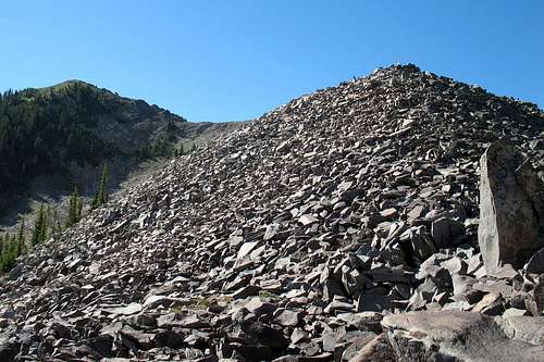
Up the talus
Camping
You could camp near the peak as I noted several places with fire rings and which seemed to be hunter camps. No organized campgrounds but the Palisade Lake area has several campgrounds such as McCoy Creek.McCoy Creek Campground
Location: From Alpine, WY go 5 miles south on Hwy 26/89 then 7 miles north on Forest Rd 087. 19 campsites at the southern end of Palisades Reservoir available on a first come, first serve at $8/night single and $16/night double.
Other campgrounds in the Palisades area: Click here.
From the Caribou National Forest website comes this following statement:
"The Caribou National Forest is not as large as some national forests in the northwest nor does it have the recreational diversity of its neighboring national forests. It is, however, a quiet undiscovered forest with quality car, tent, motorhome and recreation vehicle (RV) camping, super hiking, and magnificent wildlife viewing opportunities. This Forest takes some effort to get to know but is well-worth every visit."
Weather for area


Climbing route
This mountain doesn't seem to get many visitors (see peakbagger) and normally I take pictures of the register and views in each direction from the summit. Unfortunately I dropped my camera and it quit working which is always maddening but today I have a phone with a camera that substitutes when mishaps occur. But my flip up phone back then didn't take pictures. If anyone climbs this peak, please add pictures from the summit and a pic or two of the register. The last picture before I dropped the camera was on the northwest ridge. I found out later that the camera was a total loss and it cost me a lot of good pics that I missed due to that fact. I now use my smart phone along with carrying a camera so I'm good and covered.This mountain can be climbed from several directions but the only route I can share experience with is the Northwest Ridge, shown on the map as the red dashed line. I did go down a different way, which is roughly shown on the map as a black dashed line. From where I parked, it was not more than 1300 feet of elevation gain although the 500 feet of talus going up the NW ridge made it seem like a lot more. Mileage and elevation gain would vary from where one parks but for me, it was under 4 miles round trip. I followed directions provided by Greg Jagielski. In hindsight, I would use the central route (see it on Ken Jones GPS track) for both going up and down. The northwest ridge had several spots where it seemed most of the talus was "moving" and I found that a bit unnerving.
Ken Jones from the Seattle area made the summit and he pretty much went the same way I did. He kindly posted his GPS track at peakbagger.com and you will find this invaluable information if you have any questions at all about the route.

| 
| 
|
History
From the Caribou National forest page comes the following information:"The Caribou National Forest was not named for a member of the deer family. That's right graceful and hardy caribou never roamed the mountains and plains of what is now called Caribou National Forest. The Forest was named for the tall-tales-telling miner named Cariboo Jack. (His real name was Jesse Fairchild.) In 1870, Cariboo Jack and two fellow miners discovered gold near what is now the Caribou Mountains. This gold rush lasted 20 years, producing 50 million dollars worth of placer gold, and opened the area up to settlement. Today, much of the land roamed by Cariboo and his fellow miners is dotted with nice Forest Service managed camping locations surrounded by the magnificent southern Idaho landscaped.
Just before Cariboo Jack's discovery, the first Government-built wagon road in the west was completed. Named the Lander Trail, this road provided pioneers traveling west with a cutoff from the Oregon Trail to California. With the discovery of gold in Idaho, Lander Trail provided easy access to the new gold fields for those who wanted to try their hand at the dream. Listed on the National Register of Historic Places, visitors can still see deep ruts made by wagons in the soil and find scattered carvings in aspen groves made by pioneers using Lander Trail. Located in the Webster Range, northeast of Mill Canyon campground, time spent exploring Lander Trail will add to one's appreciation of the trials and accomplishments of our pioneering past.
