
-
 29648 Hits
-
 86.37% Score
-
 22 Votes
|
|
Mountain/Rock |
|---|---|
|
|
43.74650°N / 115.3174°W |
|
|
Hiking, Mountaineering, Trad Climbing, Scrambling |
|
|
Summer, Fall |
|
|
9730 ft / 2966 m |
|
|
Overview

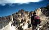
Situated between the Middle Fork of the Boise River and the South Fork of the Boise River, Steele Mountains boasts two summits: the north summit at 9575 with it's vertical north side cliffs and the south summit at 9730 with it's more gentle approaches. Local climber, Greg Parker has put up the 3 technical routes on the mountain. He's done some nice routes in the Baron Creek Drainage also near Tohobit Peak.
Here are many good routes on Steele Mountain:
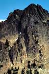
1) Quasi-Moat-O (II 5.5) - 2 Pitches; starts on vertical north side ascends large crack to easy face climbing. See 'Routes" for a more detailed description.
2) North Face (II 5.9) - Starts in the north side bowl just right of Quasi-Moat-O. Follows a diagonal ledge system up and then traverses left onto a face. Back to the right on a face or crack (you choose) leads you to the top. The top is not the true summit (it's just a nice rock pinnacle on the summit ridge) and you must rappel down and then Class 3 to the SE toward the true summit.
3) Parallel Universe (Class 4)- Snow climb early in the year on the west ridge. Split rock formation lends itself to 50 degree snow and ice.
4) Elk Creek Route (Class 3)- Follow the Elk Creek trail off the James Creek Road up to the drainage head. Then up the east slopes of the north peak and around to the notch between the summits.
5) West Slope Route (Class 2)- From Rocky Bar take Forest Road 156 to the broad saddle just west of the peak. Scramble up a steep but short forested slope around a few granite towers to the summit
6) North Ridge (Class 4)- From the Phifer Creek logging road and then the Hot Creek logging road, scramble around cliff faces or up and over small granite outcroppings until you reach the summit ridge
 |  |  |  |  |
Getting There
Road ApproachThese directions are for the technical routes on the north side of Steele Mountain. From Idaho 20 take the Featherville / Anderson Ranch Reservoir signed road north (near Cat Creek) for 18 miles until you reach the small town of Pine, Idaho. Go right (north) at the T in the road for 6 miles until you reach Paradise Hot Springs. Continue straight (north) for 4.25 miles until you reach Featherville (you'll bear right just before town). Continue straight for 8.5 miles until you reach Rocky Bar. Go left onto Bear Creek Road for 6.25 miles and then go right onto a less traveled road Phifer Creek road for 6 miles where you'll see a logging road bearing right. Take this right (Hot Creek) and loop around the north side of a slope for 5.5 miles until it dead end. You'll see glimpses of the dramatic north side of Steele Mountain when you turn the corner. Be sure to bring all the USGS quads and supplies- things change out here including roads numbers.
Hike / Scramble Approach
1) Follow the Hot Creek drainage off-trail for 3.25 miles up into the north side bowl. OR
2) From the parking area immediately gain the steep north-south running ridge to your right (west). You'll need to go around many rock towers along the 8900 foot ridge. Drop down slightly into the north basin (3.1 miles) or continue on this ridge to the south summit.
Either way is strenuous (no trails), but scenic.
 |  |
Red Tape
No permits of any kind are required. No fees or passes are required. There is campfire restriction during most of the summer and early fall.When To Climb
Standard climbing season is May through October. Conditions may vary greatly. The north side may contain snow late into the year.Mountain Conditions
Boise National Forest Sitehttp://www.fs.fed.us/r4/boise/
Nearest SNOTEL site gives latest snow depth readings:
http://www.wcc.nrcs.usda.gov/snotel/snotel.pl?sitenum=306&state=id
Camping
Camping- There are many drive-in camp sites along the way including the Anderson Ranch Reservoir area (warmer)
- Good bivy spots are found right at the Hot Creek parking area, the unnamed tiny lake on the north side of the mountain, or even on the summit ridge.
External Links
- Boise National Forest
Limited information on this huge area
- Atlanta Snow Depth Sensor
nearest SNOTEL data
Additions and CorrectionsPost an Addition or Correction
- Boise National Forest
SawtoothSean - Jun 12, 2006 1:00 am - Hasn't voted
Highland Valley SummitEver wonder what the prominent, often snow covered peak in the far distance is, when looking NE from Highland Valey Summit (Hilltop Cafe) on ID-21 through the notches in the closer hills? Steele Mountain's west face is what's most visible with the lower Sheep Mountain, less prominently in front of it. On a really clear, crisp day (winter mostly) these peaks are viewed easily from Hilltop. Other days in the summer, these can't be seen.