
|
|
Mountain/Rock |
|---|---|
|
|
44.56205°N / 111.50405°W |
|
|
Hiking, Scrambling |
|
|
Spring, Summer, Fall |
|
|
10203 ft / 3110 m |
|
|
Overview
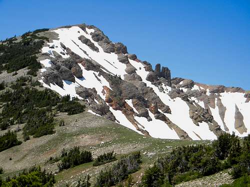 Looking up the east ridge to the summit of Mount Jefferson
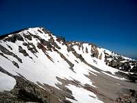 East side of Mt. Jefferson
 North cliffs of Pt. 9,800
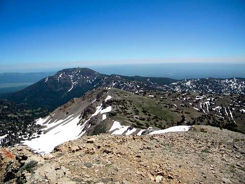
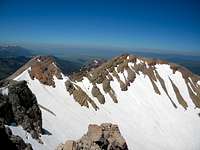 Central and west summits
 Missouri headwaters
 The summit
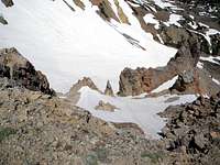 Looking down the north bowl
Mount Jefferson, at 10, 203 feet is the highest point in the Centennial Mountains, a small, local range on the border of Idaho and Montana a little west of Yellowstone. These mountains consist of a long ridge line the forms the Continental Divide between the headwaters of the Snake River and Jefferson River, which is primary headwater stream of the Missouri River. The summit area is composed of two primary ridge points with a lower point in between and a high ridge point to the east. The west ridge point is 10,161 feet, the smaller central point is approximately 10,140 feet and the separated eastern point is about 9,800 feet. The summit ridge curves to form a north facing, thousand feet deep bowl of steep talus that holds substantial snow well into the summer. The south aspect is mostly talus with a few stunted subalpine fir and whitebark pine forming krumholz nearly to the high point. There are two small lakes on the north side, Lake Maria and a smaller, shallow lake that has no name or trail to it. These sit at approximately 8,760 feet and 9,200 feet respectively and it appears both are fairly shallow. The mountain has 3,383 feet of prominence.
The mountain is situated between Henry’s Lake and Island Park Reservoir and is just west of West Yellowstone and Yellowstone National Park. In the summer the region is quite busy with tourists visiting the parks or partaking of the famous trout fishing in Henry’s Lake or the Henry’s Fork of the Snake River. There are also two popular State Parks, Henry’s Lake and Herriman close by. With Jefferson Peak being the highest mountain in the close region and having very easy access to the trailhead from the Sawtell Mountain Road it would be assumed this peak gets a lot of visitors. However, the summit register reveals relatively few users. Only a few dozen signatures are listed over recent years, which is surprising given the ease of reaching what appears to be the destination peak in the area, after Sawtell of course, which is a drive-up.
On a clear day the Tetons are clearly visible to the southwest as are the high peaks of the Lemhi and Beaverhead Mountains to the west. Good views are also had of the Tobacco Root sub ranges to the north. Yellowstone and the Absaroka Mountains lay to the east. Though smaller mountains are positioned between Jefferson and the two large adjacent water bodies, good views are still had of Island Park and Henry’s Lake. The source of the Jefferson River, considered the ultimate source of the Missouri River is found in the canyon at the south foot of the mountain.
Structurally the mountain is near the east end of the Centennial Mountains that run east to west. This unusual orientation is thought to be a result of the movement of the Yellowstone Hotspot which formed the ancient Island Park Caldera. This moving hot spot also created the well known Yellowstone Caldera in more recent times. The movement of the caldera likely formed the range as the heavy magma pushed down on the southern slopes what would become the Centennials.
Getting There
 Colors and snow about mid-way to the summit.
 Point 9,800
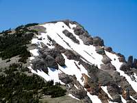 The last 600 feet up
 Almost there
 Gentle south slopes
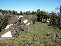 East trail segment
 East ridge point
 South slope, Pt. 9,800
 East saddle
The summit of Jefferson Peak is relatively easy to reach via the Sawtell Mountain Road, a good trail and some steep, but straightforward cross country hiking. To reach this road travel north of Island Park on Highway 20 north then turn west at the signed entrance to the Sawtell Mountain Resort. There is also a Subway on the left and a Chevron Station with a little store on the right. If you find yourself on the flats near Henry’s Lake, you have gone a bit too far. The Sawtell Mountain Road is well maintained and nearly any vehicle can travel it, but be careful during summer months because traffic can be heavy and there are several tight curves. The trailhead is located on a hairpin curve 9.8 miles from the highway. Some maps show the trail leaving a little further up the road, but that entry has been removed. The current trailhead is marked by a small sign that designates the trail as a “no motorized vehicle” trail at a wide spot where three or four cars may park.
The trail is a foot path for the first stretch, but soon occupies an old road bed. This bed once connected with the older trailhead and it is assumed that connection to the Sawtell Mountain Road was removed to keep vehicles from accessing the trail. The current trail starts at 9,040 feet and is an easy up and down grade for about two and a half miles before the trail crosses the divide at 9,040 feet and enters the Rock Creek Basin north of the ridge. From here its cross country to Jefferson, but pretty easy and straight forward.
Leave the trail and head up the main ridge to the west. One can head straight up the ridge, which is not terribly steep or contour around the three bowls on the south side to the ridge saddle between Jefferson the east ridge point to avoid an ascent and descent. Once back on the main ridge line in the saddle between the 9,200 foot ridge point and the summit and simply head west up the main divide to the high point. The climb from this saddle to the summit of Jefferson Peak is about 600 feet over less than a half mile. The total distance from where the route leaves the trail is about two to two and a half miles depending on the route taken. This makes the hike between about four and five miles from the trailhead with a net elevation gain of about 1,200 feet.
 East ridge route overview
Red Tape
None.Public access to the Sawtell Mountain road is prohibited in the winter.
Camping and Lodging
 Nice camping can be found on the gentle south ridges
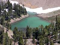 Lake Marie
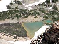 Unnamed lake
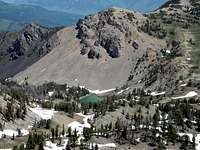 Rock Creek Basin
For the backpacker there are many nice primitive camping spots to be had. The Rock Creek Basin on the north side has many places to pitch a tent, particularly two high lakes, Lake Marie and a higher unnamed lake. The flat ridges running south from the main ridge also provide some nice camping spots, though water may be an issue at these later in the summer.
The Targhee National Forest has six good campgrounds in the area. Click on this map to see their locations, and then click on the symbol or name from the left margin for each for specific information such as fees, photos, driving instructions and contact information.
There are also two State Parks, Henrys Lake and Harriman that offer a variety of camping options and things to do.
Being a tourist area there are many private campgrounds and resorts that offer a variety of lodging and camping opportunities.
When to Climb
The best time to climb is the summer obviously. Winter use is possible because of the gentle grade on the south side of the ridge. The Sawtell Mt. road is actually kept open in the winter due to the facilities on the top of Sawtell Mt. The road is not open to the public much of the winter so your ski or snow shoe trip is more of an expedition on foot from the gate several miles east of the trailhead. Mount Jefferson in a sea of clouds. Photo by brendon.
Mountain Conditions and Information
Go to the mountain prepared for variable conditions. A summer a day that starts out nice and clear often will see thunderstorms move into the mountains bringing rain, cold and lightning. Check the forecast closely and be prepared.For specific information contact the Island Park Ranger District of the Targhee National Forest.
Island Park Ranger District
Targhee National Forest
3726 Highway 20
Island Park, Idaho 83429
(208) 558-7301
>NOAA Forecast
 Mount Jefferson
mtybumpo - Jul 20, 2009 12:59 am - Voted 10/10
Centennial mountainsYou mentioned that Mt. Jefferson is in the Continental Mountains but I think it's actually the Centennial Mountains on the Continental Divide. I don't know of a range called the Continental Mountains.
mrh - Jul 20, 2009 10:53 am - Hasn't voted
Re: Centennial mountainsOops. I guess I got typing and thinking too fast. Good to know people actually read submissions. Thanks for pointing that out.
Indianshirt - Aug 16, 2013 11:54 pm - Hasn't voted
Bring an Extra Pair of LegsSo I decided to climb / hike to Mount Jefferson based on this website. The entry point to the trail is a road off of route 20 just like the website says. The trail head is also roughly 9.8 miles from route 20 just like the website says ( this road is the service road for the radio tower on the adjacent mountain ). The trail is roughly 5 miles to Lake Marie - and like the website says it's not that bad and really pretty. From the trail head to the lake + lunch you are looking at 3 hours. You basically are following trail 165 sign posts. Then comes Mount Jefferson. From Lake Marie to Mount Jefferson is a freakin death climb from hell. There is no way that a normal Joe can climb this mountain from the lake. You will need several hours, gallons of water and a new pair of legs. Outside of the fact that you will never get to the summit, the hike from the road to the lake then up the mountain as far as you can go it really pretty. If you are relatively in shape and have visions of grandeur of climbing this beast don't be disappointed if at some point you realize the journey is hopeless and beyond your reach. The hike is really nice, but the mountain will kill you.