
-
 35559 Hits
-
 84.82% Score
-
 19 Votes
|
|
Mountain/Rock |
|---|---|
|
|
38.39255°N / 78.76996°W |
|
|
Rockingham |
|
|
Hiking |
|
|
2922 ft / 891 m |
|
|
Overview
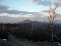
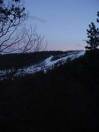
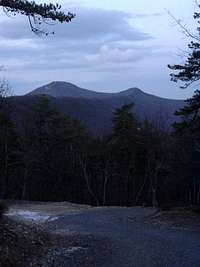
Massanutten Peak stands at the southern end of the Massanutten Mountains, rising about 1500 feet above the nearby city of Harrisonburg. Although it is best known for the Massanutten Resort that offers skiing, snowboarding, and snowtubing, Massanutten Peak is also popular with hikers, especially members of the resort. It is one of the few privately owned peaks in the Massanutten Mountains. Good views are available in all directions, including the Blue Ridge Mountains in Shenandoah National Park and Hartman, Kaylor, and Lairds Knob. The vertical rock layers visible on the Ridge Trail show the geological folding processes that created the Massanutten Mountains before the first dinosaurs walked the Earth.Getting There


Access Road: From Harrisonburg, drive east on US 33 until reaching SR 644 (Resort Drive). Turn left and follow SR 644 until Massanutten Drive, where you make another left. Continue to Peak Drive and bear right. Follow Peak Drive until Rainier Road, where you make a left. Follow Rainier Road until the end and park here, but not in front of the gate for the ski area. Start hiking up the access road, which climbs steeply away from Rainier Road. After about a mile, you will reach the end of the access road near some cell phone towers, which offer views to the north. Continue on the trail to the summit. A little beyond the summit are the best views on the hike.
Round trip: A little over 2 miles with an elevation gain of about 800 feet.
Ridge Trail: From Harrisonburg, drive east on US 33 until reaching SR 644 (Resort Drive). Turn left and follow SR 644 until Massanutten Drive, where you make another left. Continue to Del Webb Drive and make a right. Follow Del Webb Drive and up to the crest of the ridge, where there will be a parking lot on the left.
Park here, enjoy the views, and then start up the Ridge Trail, which is on this side of Del Webb Drive. Hike along the Ridge Trail for 2.25 miles, where it merges with the access road. Continue up the access road and then the trail to the summit and overlooks.
Round trip: 4.8 miles to the summit with an elevation gain of 1400 to 1500 feet.
See the map of the Massanutten Resort for more details.