
-
 10704 Hits
-
 86.37% Score
-
 22 Votes
|
|
Mountain/Rock |
|---|---|
|
|
46.44566°N / 14.41059°E |
|
|
Hiking, Mountaineering, Trad Climbing, Scrambling, Via Ferrata, Skiing |
|
|
Spring, Summer, Fall, Winter |
|
|
6998 ft / 2133 m |
|
|
Overview
 From the north - from Sela/Zell
 From the north
 Branko - From the west
 From the west
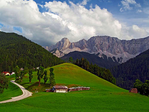
The long, beautiful 12 km long range of Košuta/Koschuta already has its page, but a few distinct summits in it are so important that they deserve its own. Details about their routes will come from the members and it is also true that in most cases they, and not the whole range, are the objective of a trip. In Slovenian language košuta means a hind and on the northern side of the range there is also a farm with this name. The word turn means tower.
By the whole range today the border between Austria and Slovenia runs, but for mountaineering visits it is a non issue. All mountains in Košuta range are beautiful creatures with a very different northern and southern side. While the southern (Slovenian) side is grassy, the slopes are only on a few places intermitted with rocks, the northern (Austrian) side is a true long rock wall, over which easier passages are posible only on a few places.
Košutnikov Turn is a rocky tower in this wall. In its solid northern face there are many nice and also quite hard climbing routes. Actually in the vicinity of Košutnikov Turn also the nature of the southern side changes considerably. Also there you will find steep rocky sections, falling down in the valley of Dolga Njiva.
Košutnikov Turn is a goal of hikers and climbers in summer. In winter it is not so frequently ascended, but with the right equipment it offers nice winter tours and in very good conditions allows also skiing down from its very top. That is however already an alpinistic ski tour.
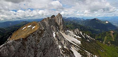
As from the whole Košuta range, the view from Košutnikov Turn is very broad. On the SE Kamnik and Savinja Alps are rising high, on the NE the massif of Obir attracts views, along the range of Karavanke / Karawanken you can see a lot of summits of an equal height rising and in the distance there are Julian Alps. On the southern side the hilly Slovenia can be well seen and on the northern side in the distance many groups of Eastern Alps.
 Košutnikov turn from the east, from Tolsta Košuta
Geographic Description
| Being a ridge mountain, the structure of Košutnikov Turn is quite simple. The Košuta range comes from the west with summits of just a little lower altitude. The last one before Košutnikov Turn is Ostrv, 2104 m, more further to the west is Macesje / Laerchenberg, 2124 m. From the north, the walls of these summits are called Breitwand and Mittelwand. From Ostrv the ridge lowers only a little on the notch just before Košutnikov Turn. There the marked routes from the south and north come up. On the other side of the summit head there is a similar notch where from the Austrian side the NE couloir comes up. The continuation of the main ridge then goes sharply over several ridge bumps to the summit of Tolsta Košuta / Dicke Koschuta. Towards the north, Košutnikov Turn has a pillar-like wall, but on its feet there is a small notch, called Vilce / Wilze. The rock north of it has the elevation of 1799 m and the ridge from it continues northwards. The southern slopes of Košutnikov Turn are formed of steep grassy and rocky terrain. Between the rocks, several ravines are falling down to the valley of Dolga Njiva. |
Getting There
 Sela/Zell
The southern approach on Košutnikov Turn goes from Tržič town, lying by the road which goes over Ljubelj / Loibl pass. From Tržič you drive along Tržiška Bistrica creek deep into the valley - the direction is NE. You pass Jelendol, a more and more narrow road brings you to Medvodje, finally the mountain road reaches below Dolga Njiva, where it turns right towards other alpine meadows. You can park on that road, just some 10 minutes below Dolga Njiva hut. In winter this road is almost allways cleaned till Jelendol, in times of tour skiing season also to Medvodje. From there on the road is usually covered by rests of lawines so a ski tour usually starts in Medvodje, 900 m. From there to Dolga Njiva it can take you some 2 hours on skis.
The northern approaches go from Koschutahaus, 1280 m, which can be in summer reached by a good road (private, toll!) from Sele-Fara / Zell-Pfarre. In winter this road might get cleaned only in May when the hut opens. Otherwise see the main page how to reach Sele / Zell.
Routes Overview
 flow - On the northern ascent
Hikes and Ferratas
1. South ascent - western variant. From Dolga njiva private hut you go a few minutes towards the W, following the marked path which connects alpine meadows below Košuta. In a forrest there's a well marked crossroads where you deter uphills (in the N direction). The path is steep, but well beaten and marked. It winds up in several turns, choosing best passages in the terrain. After good 1 hour some more care is needed, especially in summer when grass is higher. Don't follow a hunters path which goes left across the slopes and also not the other path, going right. Just proceed up, at the end a bit towards the right until you reach the notch on the main ridge. There turn right and follow the main ridge to the top. 2 h 15 min from Dolga Njiva, 2 h 30 min from the parking place on the road. Difficulty grading by the SAC & DAV scale would be T2.
 The southern slopes in winter
2. South ascent - eastern variant. From Dolga njiva private hut you continue by alpine meadows towards the east. When reaching the upper meadows of Dolga Njiva, south of Tolsta Košuta, you turn by the marked path sharp left and start ascending over the slopes of Košutnikov Turn. Through dwarf pines you reach a steeper section, there the path starts winding up through passages among steep rocks. The path gets steep and on several places also exposed. It keeps going in the western direction, passing above distinct red rocks and below the summit joining the variant 1. Overall, the path is well marked, but goes over an exposed terrain. From Dolga Njiva 2 h 45 min. Difficulty grading by the SAC & DAV scale would be T3.
3. North ascent - western variant. From Koschutahaus we follow the inscription towards the left. A good marked path (No. 601) goes eastwards, first on Grosova planina / Grosalm, then on an overgrown Mejnik saddle (1500 m, 30 min till here). There is a crossroads, we follow now the path No. 642, going slightly up towards the walls of Košutnikov Turn. On the scree slope the path branches again. While the left branch (see below variant 4) goes around the mountan, we deter right up towards the west ravine of Košutnikov Turn. By the ravine we climb steeply, the path is well protected by iron pegs and in a pleasant climb we reach the notch on the main ridge. From there it's only some 15 more minutes to the highest point. 2 h 45 min from Koschutahaus. Difficulty grading by the SAC & DAV scale would be T4 (or, an easy ferrata, Austrian grade B). Actually, just below the exit the ferrata branches into the B/C variant (over an attractive bridge) and the usual B continuation.
 The NE side
4. North ascent - eastern variant. From Koschutahaus we go as described above till the scree field below the west ravine. There the path branches. We continue left by the path No. 643, across the slope and finally on the Vilce / Wilze notch. On the other side we descend again on the scree slopes and then below the walls ascend them again till the entry of the East ravine of Košutnikov Turn. The first part of the ravine is steep and unpleasant, higher there is a rocky section which must be overcome. On this place the path is protected, but in the last years avalanches and landslides ruined it a lot so the passage might be dangerous. After we exit the ravine, the path continues across the southern slopes and up to the highest point. 3 h from Koschutahaus. Difficulty grading by the SAC & DAV scale would be T4 (or easier, depending on conditions). Attention: In the last years this route is not maintained any more and is formally closed!
5. By the west ridge. From alpine meadows on the west and by the whole ridge of Košuta a quite demanding marked path goes. Crossing the whole range of Košuta is one of the most beautiful tours in Karavanke. Of course you can come up on Košutnikov Turn by that way from the west, but it is also possible to do a steep ascent from Dolga njiva and then continue by the main ridge towards the west. Difficulty grading of the ridge path would be by the SAC & DAV scale T3.
 The ridge from Tolsta Košuta (E ridge)
6. By the east ridge. From the summit of Tolsta Košuta a sharp ridge goes towards Košutnikov Turn. The summit of Tolsta Košuta, 2057 m, can be easilly reached by a path from Dolga Njiva (it goes by the SE ridge, not marked). From there on you mostly follow the main ridge towards the west. The first bumps are easy, although the ridge requires come care. Then the rocky barrier on the ridge comes. You climb towards the right, after some 15 meters you find yourself on the sharp main ridge again and you follow it further on. Mostly there is a steep, very demanding hike, occasionally there are climbing sections of UIAA I degree or a little harder. When coming closer to Košutnikov Turn, you find yourself on one of the last ridge bumps. To descend it, you need to overcome the hardest section. The rock is only a few meters high, on top of it, there's a peg for belaying. If you climb down there free, the difficulty is some UIAA II+. After that, you soon reach the exit of the NE ravine and as described before the highest point of Košutnikov Turn. From Dolga Njiva private hut you have some 2 h on the summit of Tolsta Košuta and 1 h 30 min to the summit of Košutnikov Turn. Difficulty grading by the SAC & DAV scale would be T6 (climbing sections of UIAA II, exposed).
Besides the approach from Koschutahaus, from the north also several other (longer) approaches are possible, but they all join on the saddle NW od Košutnikov Turn / Koschutnikturm. See the on-line map to get hiking ideas! When I mentioned skiing from Košutnikov Turn, the obviously only reasonable variant is by the North-east ravine. The summit slopes are very steep and require perfect skills of skiing. Also the upper part of the ravine can be dangerous. It is very steep and rocks around can be in bad conditions unstable. The whole skiing is being considered already as an alpinistic skiing, not and ordinary ski tour.
Harder Climbs
Solid rock and nice up to 400 meters high walls make Košutnikov Turn very popular with climbers. Here is the list of classical routes:
- East Chimneys (Ostkamine). A. Ferc, E. Orel and R. Szalay, 1924. IV, 300 m.
- North face Chimneys (Nordwandkamine). II-III, 350 m.
- Pucher-Heider Chimneys. III, 350 m.
- North Pillar (Nordwand, Mittelpfeiler). W. Neisser, Korner & R. Ludwig, 1931. V, 350 m.
- North Edge (Nordkante). F. Knaffl and R. Weitzenboeck, 1907. IV, 350 m. Popular route.
- Lower Crossing in the W Face (Westwand, Unterer Quergang). W. Neisser, Korner & R. Ludwig, 1931. IV.
- Upper Crossing on the W Edge (Westkante, Oberer Quergang). A. Ferch and E. Orel, 1925. III-IV.
- West Wall Direct (Unmittelbare Westwand). W. Wruhs and V. Pretterebner, 1935. VI, 250 m.
Maps
You can see a detailed map on: http://www.austrianmap.at/.
Classical maps: Kompass WK 65: Klopeiner See-Karawanken. 1:50.000. Planinska zveza Slovenije: Karavanke. 1:50.000.
Red Tape
There are no restrictions on the mountain. The road to Koschutahaus must be paid (4 EUR).
Mountain Huts
 Dolga Njiva hut
1. Koschutahaus, 1280 m. reachable by a private road (toll!) from Sela-Fara / Zell-Pfarre. Opened from start of May till mid/end of October. Email: kaernten@naturfreunde.at. Web: www.naturfreunde.at. Contact: Christian Dovjak, telephone: ++43 (0) 4227 7110 (Hut), Fax: 7227, mobile: ++43 (0) 664 3468978.
2. On the southern side, on Dolga Njiva, there is a private hut, where in summer you can get food and drink.
When To Climb?
 Winter above Dolga Njiva
Košutnikov Turn can be best ascended in dry seasons. Than means mostly from June till the end of October. From the southern side (west variant), slopes can be free of snow already in May. Winter ascents require a complete winter equipment. Skiing from the summit is an alpinistic endeavor. For ascents in spring the two normal approaches from the north are recommended - the ravines are mostly covered with snow and with a proper equipment and safety measures climbs can be very rewarding.
Your Help Needed
Please add, if you have information:
- About the climbing routes in the north walls.
- Winter ascent experiences or even skiing.