
-
 17021 Hits
-
 86.85% Score
-
 23 Votes
|
|
Mountain/Rock |
|---|---|
|
|
45.53290°N / 7.26956°E |
|
|
12591 ft / 3838 m |
|
|
Overview
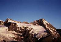
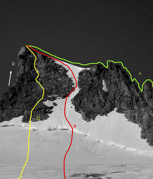
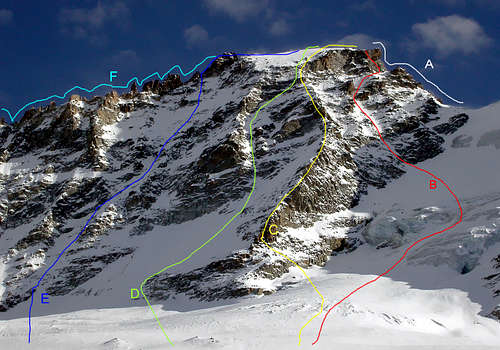
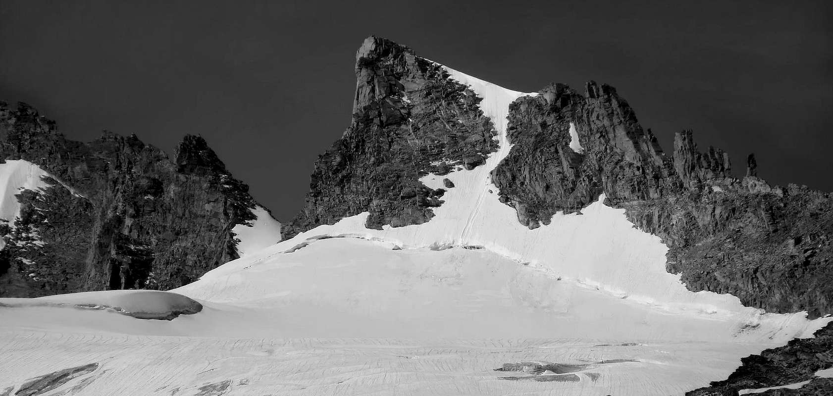
From the summit of Gran Paradiso (4.061m) a large watershed ridge descends to the North with sinuous designed to divide the valleys of Valsavarenche (West) and Cogne. In his performance as a whole series of important summits from South to North so we can list them after high Piccolo Paradiso Pass (3.877m): Piccolo Paradiso with its various tops, Becca di Montandayné, Punta dell'Herbetet, Gran Serra or Sertz, Punta di Leviona, the importantLauson or Lauzon Hill (3.296m), Punta Nera and Bianca, the famous pyramid of the Grivola immediately followed by the sister of the Gran Nomenon. In coming to this important but little known and even less frequented mountain, there is to be observed as the same is "hidden" from the mass of the Great Paradiso-Little Paradiso - lines in the South and certainly more elegant and attractive to the North of the pyramid of Herbetet. Formed by the long ridge dividing that links the two aforementioned summit, lets get down to a short ridge, in the final part from the Top until just above the quota 3.502 meters; and then stretch in the direction of to the North-east of the Herbetet Vallon at whose summit is placed and Bivouac Lionello & Lucio Leonessa (2.910m). Between these two ridges down the Northeast Slope above the Glacier Tsasset and the upper part formed by a short and small triangular rock face (about 160/70 meters) engraved in its middle by a gully-couloir which at the end turns into a crack , which culminates at the summit flanked on the right (West) by a fairly steep glacial slope (from 38° to 42°); the latter constitutes the Normal Via, starting from the bivouac, even if it does not coincide with the route traveled by the first climbers in 1875 who used, on the opposite side, the Northwest Spur and the West Wall, both uphill and downhill. The first of which acts as a partition with another wall which, with smaller dimensions and furrowed in the middle by a snowy-rocky gully, descends above the Southeastern corner of the Montandaynè Glacier, just below the homonymous hill (3.718 m). In this regard, there should be noted that the other two walls, that is, that outlined above and limited to noon by the aforementioned spur-ridge (and with two variants on the left with routes directly to the Summit and the North Crest), but also the adjacent or Southwest which, in practice, consists in the continuation of the same as well as facing the Little Paradiso (3.929m), and the South-southeast, over the Tribulation's Glacier, are quite repulsive and uninviting for the climb and on this last one was drawn, after various attempts, a difficult path in rock part of the strong Cogne Mountain Guides Vincenzo said "Cenzi" Perruchon and Alfredo Abram in August of 1961. Beautiful views of the Alps and the Gran Paradiso glance exceptional on the nearby and famous Ridge South-southwest of the Herbetet.

Dalla Vetta del Gran Paradiso (4.061 m) una grande cresta spartiacque scende con andamento sinuoso verso Settentrione atta a dividere le Valli di Valsavaranche (Ovest) e Cogne. Nel suo andamento forma tutta una serie di importanti vette che da Sud verso Nord così possiamo elencare da dopo l'elevato Colle del Piccolo Paradiso (3.877 m): Piccolo Paradiso con le sue varie sommità, Becca di Montandayné, Punta dell'Herbetet, Gran Serra o Sertz, Punta di Leviona, l'importante Col Lauson o Loson (3.296 m), Punta Nera e Bianca, la famosa piramide della Grivola subito seguita da quella gemella del Grand Nomenon. Venendo a questa importante ma poco conosciuta ed ancora di meno frequentata montagna, vi è da osservare come la stessa sia "occultata" dalla massa del Gran Paradiso-Piccolo Paradiso a Mezzogiorno e dalle linee sicuramente più eleganti ed attraenti della piramide dell'Herbetet a Settentrione. Formata dalla lunga cresta divisoria che lega le due predette sommità, lascia scendere a Nordest una breve cresta , nella parte finale dalla Vetta fino a poco sopra la quota 3.502 metri; per poi allungarsi in direzione del Vallone dell'Herbetet al cui culmine è posizionato il Bivacco Lionello e Lucio Leonessa (2.910 m). Tra queste due creste scende il Versante Nordest sopra il Ghiacciaio di Tsasset; la parte superiore è formata da una breve e piccola parete rocciosa triangolare (160/70 metri circa) incisa nel suo mezzo da un canalone che nel finale si trasforma in fessura, culminante in vetta affiancata sulla destra (Ovest) da un abbastanza ripido pendio glaciale (da 38° a 42°); questo ultimo costituisce la Via Normale, partendo dal bivacco, anche se non coincide con la via percorsa dai primi salitori nel 1875 i quali utilizzarono, sul versante opposto, lo sperone Nordovest e la Parete Ovest, sia in salita che in discesa. Il primo dei quali funge da divisorio con un'altra parete che, con dimensioni più ridotte e solcata nel mezzo da un canalone nevoso-roccioso, scende al di sopra del margine Sudorientale del Ghiacciaio di Montandaynè, proprio al di sotto dell'omonimo colle (3.718 m). A tale proposito c'è da evidenziare che le altre due pareti, cioè quella sopra citata e limitata a Mezzogiorno dal predetto sperone-crestone (e con due varianti più a sinistra con percorsi direttamente alla Vetta ed alla Cresta Nord), ma anche l'adiacente o Sudovest che, in pratica, consiste nella continuazione della medesima nonché rivolta verso il Piccolo Paradiso (3.929 m), e la Sud-sudest, al di sopra del Ghiacciaio della Tribolazione, sono alquanto repulsive e poco invitanti per la salita; su questa ultima è stata tracciata, dopo varii tentativi, una difficile via in roccia da parte delle forti Guide di Cogne Vincenzo "Cenzi" Perruchon e Alfredo Abram nell'Agosto del 1961. Belle vedute su tutto l'arco alpino del Gran Paradiso e colpo d'occhio eccezionale sulla vicina e famosa Cresta Sud-sudovest dell'Herbetet.
First Ascents
- First in the summit (NW Wall and NW Arête): Luigi Vaccarone, A. Gramaglia Richiarsi, Antonio and Daniele Castagneri, (Aug 22th, 1875).
- In Winter: E. Adami, P. and S. Ceresa, (Dec 28th, 1875).
- S-SW Arête: John Percy Farrar, D. Maquignaz and Koderbacker Junior, (Aug 13th, 1898).
- W-SW Face (couloir to the right by NW Spur): Osvaldo Cardellina and Marco Cossard, (Aug 31th, 1982); in ascent in day from Pont Valsavarenche, Vittorio Emanuele Refuge, Laveciau and Montandayné Glaciers and first part on Western Slope of Montandayné Col; in descent N-NE Face on Tsasset Glacier and West Slope of Tsasset's Finestra towards Montandayné Glacier and Alp, Lavassey and Praviou Dèsot Pastures.
- Northwest Spur and Western Wall in final part: Luigi Vaccarone, A. Gramaglia Ricchiarsi with the Susa's Valley Mountain Guides Antonio and Daniele Castagneri, (Aug 22th, 1875); in ascent from Pont Valsavarenche.
- W Wall (direct route): Mario Grassi and Angelo Boggio Marzet, (Aug 08 th, 1943); in ascent from Pont Valsavarenche.
- W Wall and N Arête: Camillo and G. Bianco, (Aug 13th, 1938).
- North-northeastern Ridge: William Auguste Brevoort Coolidge, George Yeld, Christian Almer Junior and Sylvain Henry, (Summer 1885); in descent to great shoulder before the Tsasset Finestra. First repetition: Renato Chabod and Luigi Bron, (Sep 22th, 1929); in ascent from Finestra de Tsasset.
- N-NE Face (snowy face to the right and Northern Crest in final part): W. A. B. Coolidge, George Yeld, Christian Almer Junior and Sylvain Henry, (Summer 1885).
- E-NE Wall (direct via on rocky triangular face to the left or East): Osvaldo Cardellina, Marco Cossard, Camillo Roberto Ferronato, Michelino Furci and Giuseppe Lamazzi, (Aug 02th, 1981); in ascent in day from Valnontey Hamlet, Pont des Eurfelets, l'Herbetet Alp, Lionello & Lucio Bivouac, Glacier de Tsasset.
- E Arête: Ottorino Mazzalama, I. Brosio Jean D''Entrèves and R. Craveri, (Jul 27th, 1930); in ascent from Valnontey and through the Tsasset's Glacier.
- S Wall: Cogne's Mountain Guides Vincenzo Perruchon and Alfredo Abram, (Aug 06-07th, 1961); in ascent from Cogne, Valnontey, through Tribolazione's Glacier.
Getting There
Getting There BY CAR: Valle di Cogne- From Torino, Milano, etc: Motorway A5. Exit at Aosta Ovest. Drive to the near Aymavilles. Follow the directions for Valle di Cogne.
- From Switzerland: through the Grand Saint Bernard Tunnel or the namesake pass. Drive to Aosta, then follow the direction for Courmayeur on SS.26. Just after Sarre, turn to the left, in the direction of Valle di Cogne.
- From France: through Mont Blanc Tunnel or Petit St. Bernard Pass. It isn't necessary to take Motorway A5: you can drive on SS.26, in the direction of Aosta. Before arriving at the Village of Sarre, turn right following the sign for Valle di Cogne. After Aymavilles, the SR.47 crosses the Villages of Vieyes, Epinel and Cretaz and after about 25 Km arrives at Cogne (1.534m). From Cogne you can get the Village of Valnontey(1.666m).
- From France: through the Mont Blanc Tunnel or the Col du Petit Saint Bernard: you can drive on SS.26, following the direction for Aosta and, before arriving in Villeneuve, turn right towards Introd. Alternatively, you can take Motorway A5 (at Courmayeur or Morgex) and exit at Aosta Ovest.
- From all other directions: get to the Aosta Ovest exit of Motorway A5. Then drive along SS.26 Aosta, direction Courmayeur, and just after Villeneuve turn left towards Introd. Shortly after Introd, you arrive at a junction: turn left, entering in Valsavarenche and then, before arriving at Pont (1.978m) where the road ends, you will touch the Villages (Degioz, Eaux Rousses, etc) where the pathways to "Casolari" Superiori di Leviona, Sberna Bivouac, Chabod Refuge start from.
- Aeroporto "Corrado Gex" Saint Christophe (Aosta).
 |
 |
 |
 |
 |
Approach
From Valnontey (1.674m) pass on the bridge over the river with the same name and path n° 18 Alta Via n° 2 reach the Restaurant Tsantelet (1.677m) and immediately after the Paradisia Alpine Garden (worth a visit): After six small hairpin bens and a short diagonal in the Southwest to a small waterfall. Continue with the same direction and crossing the stream twice, the Casotto P.N.G.P. (Cabine of Gran Paradiso National Park) and just below the Refuge Vittorio Sella (2.579m; 1h'45/2h'00). From West to abandon this path n° 18 and the High Route n° 2 leading up to the Lauson Hill and bending South-southeast instead take the path n° 18B/TVC in the direction of the famous lakes as small as Lauzon (2.655m, 2.636m; exceptional encounters with herds of chamois and ibex along the way), and from these proceed towards a small hill between the Bec du Vallon (2.838m) and the Penne Sengia (2.660m), thus entering the next valley. With semi-circular path bypassing the first of these summits and passing by a small fork at an altitude of 2.645 meters move gradually towards the bottom of the valley reaching Torrent Great Vallon in the homonymous valley, significantly changing the direction in Southeast achieve the Plan de Resellaz (2.526m). By varying the direction again in South-southwest cross a small stream and soon after the secondary Herbetet (2.441m) and the adjacent P.N.G.P. lodge (2.395m), from this completely reverse the march towards Northwest and through a dozen hairpin bends through the trail n° 22G climb up to a junction, leaving a side trail to the right of short duration, turn to the west reaching the Torrent de l'Herbetet, and bowing very much in the South, the Bivouac dedicated to the brothers Lucio and Lionello Leonessa (2.910m); 3h'45/4h'15 from Valnontey, for the day trip from Valnontey calculate from 9 to 10 hours, ascent that requires, in this case, high degree of training).
Da Valnontey (1.674 m) passare sul ponte sopra il torrente omonimo e con il sentiero n° 18 Alta Via n° 2 raggiungere il Ristorante Tsantelet (1.677 m) e subito dopo il Giardino Alpino Paradisia (degno di visita): dopo sei piccoli tornanti ed un breve diagonale a Sudovest raggiungere una piccola cascata. Continuare con la medesima direzione e, attraversato due volte il torrente, il Casotto P.N.G.P. e subito appresso il Rifugio Vittorio Sella (2.579 m; 1h'45/2h'00). Da questo abbandonare ad Ovest il sentiero n° 18 e l'Alta Via n° 2 che sale verso il Col Lauson e piegando a Sud-sudest prendere invece il sentiero n° 18B/TVC in direzione dei tanto piccoli quanto famosi laghetti del Loson (2.655 m, 2.636 m; incontri eccezionali con branchi di camosci e stambecchi lungo il percorso); da questi proseguire verso un piccolo colle tra il Bec du Vallon (2.838 m) e la Penna Sengia (2.660 m) entrando così nel successivo vallone. Aggirando con percorso semicircolare la prima di queste sommità e passando da una piccola forcella a quota 2.645 metri portarsi gradualmente verso il fondo del vallone raggiungendo il Torrent Gran Vallon dentro l'omonimo vallone; cambiando decisamente la direzione in Sudest raggiungere il Plan de Resellaz (2.526 m). Variando nuovamente la direzione in Sud-sudovest attraversare un piccolo torrente secondario e subito dopo i Casolari dell'Herbetet (2.441 m) e l'attiguo Casotto del P.N.G.P. (2.395 m); da questo invertire completamente la marcia verso Nordovest e tramite una dozzina di stretti tornanti tramite il sentiero n° 22G salire fino ad un bivio; lasciando a destra un sentiero secondario di breve durata, volgere ad Ovest raggiungendo il Torrent de l'Herbetet e, piegando decisamente a Sud, il Bivacco dedicato ai fratelli Lucio e Lionello Leonessa (2.910 m); 3h'45/4h'15 da Valnontey; per la gita in giornata da Valnontey calcolare dalle 9 alle 10 ore, ascensione che richiede, in questo caso, ottimo grado di allenamento).
Route
Since Leonessa Bivouac directed via path of moraine towards Southwest reaching Colle Southern of the Herbetet (3.309m) by means of a debris couloir or with residues of snowfield, the same is placed to the East of the edge East-northeast of Herbetet at two small bits called "Tours of Herbetet". This hill is the entrance door to the terminal part of the Tsasset Glacier at an altitude of 3.350/70 meters about, between the crest and the West reclining on a large rocky area above the glacier on the opposite side of the Tribolazione Glacier (1h'30/1h'45). Climb the same with some zig-zag tour among the crevasses, usually not too numerous, and passing below the South Face-southeast of Herbetet climb to the Bonney Carving (3.587m), between the Herbetet and Point Budden, without reach it; instead continue further South, leaving on the right also rather close to Fenetre Tsasset (3.673m), and with moderate slope to reach a fairly large crevasse at the base of the North Ridge . This takes you to the base of the wall at a height of 3.800 meters Northeast, cross the crevasse (usually on the left or East); gradually come to the right above the snowy slope (an average of 35/38°) and with just winding path to reach the final part consisting of rocks quite steep but easy to climb (2h'45/3h'00) from Hill South of the Herbetet; 4h'45/5h'15 from the bivouac).
IN DESCENT: by the same route.
 |
 |
 |
 |
 |
Dal Bivacco Leonessa indirizzarsi tramite percorso su morena verso Sudovest raggiungendo il Colle Meridionale dell'Herbetet (3.309 m) per mezzo d'un canale detritico o con residui di nevaio; lo stesso è posto ad Est dello spigolo Est-nordest dell'Herbetet presso due piccole punte dette "Tours de l'Herbetet". Questo colle costituisce la porta d'ingresso alla parte terminale del Ghiacciaio di Tsasset a quota 3.350/70 metri circa, compreso tra la cresta spartiacque ad Occidente adagiantesi su d'una grande fascia rocciosa al di sopra del Ghiacciaio della Tribolazione nel lato opposto (1h'30/1h'45). Risalire il medesimo con qualche zig zag tra i crepacci, solitamente non troppo numerosi, e passando al di sotto della Parete Sud-sudest dell'Herbetet salire verso il Col Bonney (3.587 m), tra l'Herbetet e la Punta Budden, senza però raggiungerlo; continuare invece più a Sud, lasciando sulla destra anche l'alquanto vicina Fenetre di Tsasset (3.673 m), e con moderata pendenza raggiungere una crepaccia abbastanza grande nonché terminale alla base della Cresta Nord. Si raggiunge così la base della Parete Nordest a quota 3.800 metri circa; valicare la crepaccia (in genere sulla sinistra od Est); rientrare gradualmente sulla destra nel soprastante pendio nevoso (mediamente 35/38°) e con percorso appena sinuoso raggiungere la parte finale costituita da rocce abbastanza ripide, ma facili da scalarsi (2h'45/3h'00) dal Colle Meridionale dell'Herbetet; 4h'45/5h'15 dal bivacco).
IN DISCESA: tramite la stessa via.
Difficulty
The route can be classified as F or F+ depending on mountain conditions, to be done only by experienced and trained climbers.
L'itinerario è classificato da F a F+ dipende dalle condizioni della montagna, si consiglia ad alpinisti allenati ed esperti.
Gear
High mountain gear: rope, iceaxe, crampons, helmet and torch.
Da alta montagna: corda, piccozza, ramponi, casco e pila frontale.
Mountain Conditions
- Meteo: you can find all the needed informations at the official site of the Valle d'Aosta Region:
- Valle d'Aosta Meteo
- Meteo: You can find more weather information on the website 3B Meteo:
- Meteo Cogne
- Meteo: You can find more weather information on the website 3B Meteo:
- Meteo Valsavarenche
Webcam
- WEBCAM on Aosta Valley:
- Webcam
Books and Maps
BOOKS:
- "I Rifugi della Valle d'Aosta" di Stefano Ardito, Ed. Guide iter, Febbraio 2003.
- "Parco Nazionale del Gran Paradiso" di Stefano Ardito, Ed. Guide iter, Novembre 2001.
- "Guida delle Alpi Occidentali", di Giovanni Bobba e Luigi Vaccarone C.A.I. Sezione di Torino Volume II (parte II), 25 Maggio 1896.
- "Gran Paradiso", A. Gegenfurtner, G. Klotz, F. Müller, Ed. Bergverlag Rudolf Rother, Monaco 1980 (in tedesco).
- "Gran Paradiso", G. Klotz, Ed. Bergverlag GmbH Rother, Monaco 2005 (in tedesco).
- "Diari Alpinistici" di Osvaldo Cardellina e Indice Generale accompagnato da Schedario Relazioni Ascensioni 1964-2019 (inediti).
- "Rifugi e bivacchi in Valle d'Aosta", di Cosimo Zappelli aggiornata da Pietro Giglio, Musumeci Editore, Luglio 2002.
- "Guida della Regione Autonoma Valle d'Aosta" di Mario Aldrovandi,Ed. S.P.E. di Carlo Fanton, Torino 31 Dicembre 1964.
- "Guida dei Monti d'Italia-Gran Paradiso Parco Nazionale" E. Andreis, R. Chabod, M. C. Santis, Club Alpino Italiano/Touring Club Italiano, prima Ed. 1939; seconda Ed. 1963; terza Ed. 1980.

|

|

|

|

|
MAPS:
- Kompass "Gran Paradiso Valle d'Aosta Sentieri e Rifugi" Carta Turistica 1:50.000.
- L'Escursionista "Valsavarenche Gran Paradiso Carta dei Sentieri" (n° 9) 1:25.000.
- Meridiani Montagne "Gran Paradiso" 1:25.000.
- Enrico Editore Ivrea-Aosta "Gruppo del Gran Paradiso" 1:50.000.
- L'Escursionista "Valle di Cogne Carta dei Sentieri" 1:25.000.
- L'Escursionista "Tour de la Vallée de Cogne Grand Paradis" 1:25.000.
- I.G.C. Istituto Geografico Centrale "Parco Nazionale del Gran Paradiso" 1:50.000.
- Studio F.M.B. "Gran Paradiso" Bologna 1:50.000.
- I.G.C. Istituto Geografico Centrale Torino "Valsavarenche Val di Rhêmes Valgrisenche P.N.G.P.", 1:25.000.
Important Information
- REGIONE AUTONOMA VALLE D'AOSTA the official site.
- FONDAZIONE MONTAGNA SICURA Villa Cameron, località Villard de la Palud n° 1 Courmayeur (AO) Tel: 39 0165 897602 - Fax: 39 0165 897647.
- SOCIETA' GUIDE DI COGNE Tel. 347/9473526 – 328/1373728.
- A.I.A.T. Cogne Gran Paradis via Bourgeois n° 34 Tel. 0165-74040. E-mail: aiat@cogne.org
- A.I.NE.VA. (Associazione Interregionale Neve e Valanghe).
- Ezio Sport articoli sportivi - via Bourgeois n° 64 Phone: 016574204.
- SOCIETA' GUIDE ALPINE DEL GRAN PARADISO Comune di Valsavarenche.
 |
 |
 |
 |
 |
Useful Numbers
- Soccorso Alpino Cogne (SAR) Tel. 3482685406.
- Protezione Civile Valdostana località Aeroporto n° 7/A Saint Christophe (Ao) Tel. 0165-238222.
- Bollettino Meteo (weather info) Tel. 0165-44113.
- Unità Operativa di Soccorso Sanitario (Emergency Medical Assistance). Phone: 118.