Routes


Wallis/Valais, Switzerland, Europe
11 miles away
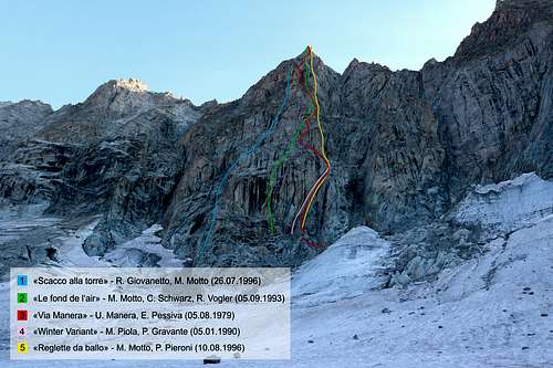
Route Type: Mountaineering, Trad Climbing, Sport ClimbingDifficulty: TD+, 6c (6a obl.)
Grade: II
Rock Difficulty: 5.11a (YDS)
Parents: Portalet, Petit Clocher/Clock Tower

")
Aosta Valley Nus/St. Barthélemy Bionaz Municipalities, Italy, Europe
11 miles away
Route Type: Mountaineering, Trad ClimbingDifficulty: PD+/PD- (Shortly Difficult Average)

Italy, Switzerland, Europe
11 miles away
Route Type: Mountaineering, Ice ClimbingDifficulty: 450 meters. Ice up to 80 degrees (D-)
Parents: Punta Kurz north face Punta Kurz

")
Aosta Valley France Suisse, Italy, Europe
12 miles away
Route Type: MountaineeringDifficulty: AD-
Parents: Mont Dolent


Valais, Switzerland, Europe
12 miles away
Route Type: Easy rock climbDifficulty: Easy climb
Parents: Pierre Avoi

Mont Blanc Massif, France/Italy/Switzerland, Europe
12 miles away
Route Type: Snow/Glacier ClimbDifficulty: AD
Parents: Mont Dolent


Aosta, Italy, Europe
12 miles away
Route Type: MountaineeringDifficulty: F-PD
Grade: I
Rock Difficulty: Class 3
Parents: Mont Dolent

Massif du Mont Blanc, France, Europe
12 miles away
Route Type: Glacier climb + Rock scrambleDifficulty: PD
Parents: Le Tour Noir
Massif du Mont Blanc, France, Europe
12 miles away
Route Type: Basic Snow/Glacier Climb - rock climbing to IIDifficulty: PD
Parents: Le Tour Noir


France, Europe
12 miles away
Route Type: MountaineeringDifficulty: AD
Grade: III
Parents: Le Tour Noir


Aosta Valley, Italy, Europe
12 miles away
Route Type: ski mountaneringDifficulty: Medium skiers
Parents: Pointe Valletta

Aosta Valley, Italy, Europe
12 miles away
Route Type: PathDifficulty: Easy walk
Parents: Chaligne (Croix de Chaligne)

Aosta Valley, Italy, Europe
12 miles away
Route Type: PathDifficulty: Easy walk
Parents: Chaligne (Croix de Chaligne)

Aosta Valley, Italy, Europe
12 miles away
Route Type: Hike till the East top, easy scramble the last 80Difficulty: Walk-up till the East top, take care from the East top to the West one
Parents: Mont Fallère

Aosta Valley Gignod Etroubles St. Oyen Municipalities, Italy, Europe
12 miles away
Route Type: HikingDifficulty: E (Easy)

Switzerland, Europe
13 miles away
Route Type: MountaineeringDifficulty: 600 meters, III+ (AD+)
Rock Difficulty: 5.4 (YDS)
Parents: Dent de Tsalion


Mont Blanc Massif, Wallis, Switzerland, Europe
13 miles away
Route Type: Mountaineering, Sport ClimbingDifficulty: TD sup., UIAA VI+
Rock Difficulty: 5.10a (YDS)
Parents: Aiguille de la Varappe


Haute Savoie, France, Europe
13 miles away
Difficulty: Scottish VParents: Pointes supérieures de Pré de Bar

Italy,
13 miles away
Route Type: MountaineeringDifficulty: TD-
Rock Difficulty: 5.10b (YDS)

 / B")
Aosta Valley: Coumayeur Pré St. Didier Morgex La Salle Avise St. Pierre Sarre Aosta Gignod Etroubles St. Oyen St. Rhémy-en-Bosses Allein Doues Ollomont Commons, Italy, Europe
13 miles away
Route Type: Hiking, Mountaineering, Trad ClimbingGrade: II

Valle d'Aosta, Italy, Europe
13 miles away
Route Type: HikeDifficulty: Walk-Up
Parents: Becca d'Avuille
