Routes


Italy, Europe
93 miles away
Route Type: Hiking, MountaineeringDifficulty: Hiking; ferrata; F/F+
Parents: Schwarzenstein / Sasso Nero


Austria, Europe
94 miles away
Route Type: Trad ClimbingDifficulty: UIAA IV+
Grade: II
Rock Difficulty: 5.6 (YDS)
Parents: Untersberg


Austria, Europe
95 miles away
Route Type: HikingDifficulty: Medium hard hike up
Parents: Ahornspitze

Alto Adige / South Tyrol, Austria/Italy, Europe
95 miles away
Route Type: Glacier and rock climbDifficulty: PD-/PD, UIAA II
Parents: Turnerkamp / Cima di Campo

Alto Adige / South Tyrol, Austria/Italy, Europe
95 miles away
Route Type: Glacier and rock climbDifficulty: D, UIAA III, IV and a passage V-
Parents: Turnerkamp / Cima di Campo


Italy, Europe
96 miles away
Route Type: Hiking, Scrambling, Via FerrataDifficulty: EEA - pp I UIAA
Parents: Pala di Mesdì


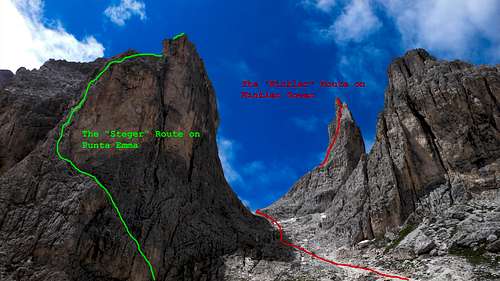
Trento, Italy, Europe
96 miles away
Route Type: Trad ClimbingDifficulty: V inf (UIAA)
Grade: V
Rock Difficulty: 5.7 (YDS)
Parents: Punta Emma

Dolomites, Rosengarten Group, Italy, Europe
96 miles away
Route Type: Via FerrataDifficulty: Medium difficult ferratta (cable route)
Parents: Catinaccio d' Antermoia / Kesselkogel


Tirol, Zillertal, Austria, Europe
96 miles away
Route Type: Mountaineering, Trad ClimbingDifficulty: UIAA V
Parents: Zsigmondyspitze / Feldkopf

")
Italy, Europe
96 miles away
Route Type: Trad ClimbingDifficulty: UIAA V+
Grade: III
Rock Difficulty: 5.8 (YDS)
Parents: Punta Emma


Dolomites, Italy, Europe
96 miles away
Route Type: Ferrata / KlettersteigDifficulty: KS3-C
Parents: Grosser Rosszahn Rosszähne / Denti di Terrarossa Roterdspitze / Cima di Terrarossa


Catinaccio group, Dolomites, Trento, Italy, Europe
97 miles away
Route Type: Trad ClimbingDifficulty: Alpine D+, UIAA V
Parents: Punta Emma

Trento, Italy, Europe
97 miles away
Route Type: Trad ClimbingDifficulty: Alpine TD inf, UIAA V+
Rock Difficulty: 5.7 (YDS)
Parents: Catinaccio - Rosengartenspitze


Catinnaccio, Italy, Europe
97 miles away
Route Type: Via FerrataDifficulty: C
Parents: Roda di Vaèl / Rotwand Catinaccio (Rosengarten)

Italy, Europe
97 miles away
Route Type: Hiking, Via FerrataDifficulty: Medium hard hike up (T4)
Parents: Roda di Vaèl / Rotwand

Südtirol / Alto Adige, Italy, Europe
97 miles away
Route Type: HikingDifficulty: Hike and Scramble
Parents: Schlern / Sciliar


Berchtesgadener Land, Germany, Europe
99 miles away
Route Type: Via FerrataDifficulty: D (Kurt Schall A->E)
Parents: Hochstaufen Berchtesgaden Alps


Bavaria, Germany, Europe
99 miles away
Route Type: HikingDifficulty: long hike with easy rock scramble
Grade: I
Parents: Hochstaufen Zwiesel

South Tyrol / Trentino, Italy, Europe
99 miles away
Route Type: ScrambleDifficulty: Walk-Up
Parents: Schenon/Oestl. Latemarspitze


Südtirol / Alto Adige, Italy, Europe
99 miles away
Route Type: HikingDifficulty: Hike
Parents: Schlern / Sciliar

Dolomites, Italy, Europe
99 miles away
Route Type: Exposed HikeDifficulty: Walk-Up
Parents: Schlern / Sciliar

Dolomites, Italy, Europe
99 miles away
Route Type: HikeDifficulty: Walk-Up
Parents: Schlern / Sciliar