Routes


Italy, Europe
16 miles away
Route Type: Hiking, Scrambling, Via FerrataDifficulty: EEA - pp I UIAA
Parents: Pala di Mesdì

")


Trentino-Alto Adige, Italy, Europe
17 miles away
Route Type: Via FerrataDifficulty: Short, but hard ferrata
Parents: Marmolada Group

")
Belluno (Veneto), Italy, Europe
17 miles away
Route Type: "Technical" hike (Via ferrata)Difficulty: Technical hike
Parents: Pomagagnon


Italy, Europe
17 miles away
Route Type: Trad ClimbingDifficulty: UIAA V (5.8 YDS)
Grade: III
Rock Difficulty: 5.8 (YDS)
Parents: Pomagagnon


Italy, Europe
17 miles away
Route Type: Hiking, ScramblingDifficulty: Demanding scramble
Parents: Sasso Vernale

Südtirol/Alto Adige, Italy, Europe
17 miles away
Route Type: Hiking, Via Ferrata

South Tirol, Italy, Europe
17 miles away
Route Type: Ice ClimbingDifficulty: WI 3+ - WI6
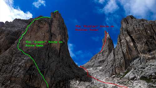
Italy, Europe
17 miles away
Route Type: Trad ClimbingDifficulty: UIAA V+
Grade: III
Rock Difficulty: 5.8 (YDS)
Parents: Punta Emma


Trento, Italy, Europe
17 miles away
Route Type: Trad ClimbingDifficulty: Alpine TD inf, UIAA V+
Rock Difficulty: 5.7 (YDS)
Parents: Catinaccio - Rosengartenspitze

Belluno (Veneto), Italy, Europe
17 miles away
Route Type: HikingDifficulty: Walk-up, easy
Parents: Croda da Lago Lastoni di Formin


Südtirol / Alto Adige, Italy, Europe
17 miles away
Route Type: HikingDifficulty: Hike
Parents: Dürrenstein / Picco di Vallandro

Dolomites, Belluno, Italy, Europe
17 miles away
Route Type: Trad ClimbingDifficulty: Alpine TD
Grade: VI
Parents: Lastoni di Formin

Südtirol / Alto Adige, Italy, Europe
18 miles away
Route Type: Hiking, Mountaineering, ScramblingDifficulty: Exposed scramble
Parents: Tagewaldhorn / Corno di Tramin

Südtirol / Alto Adige, Italy, Europe
18 miles away
Route Type: HikingDifficulty: Hike and Scramble
Rock Difficulty: Class 3
Parents: Tellerjochspitze / Montello Jakobspitze / Cima di San Giacomo

")
Belluno, Italy, Europe
18 miles away
Route Type: Sport ClimbingDifficulty: TD, UIAA VI-
Parents: Campanile Federa

Südtirol / Alto Adige, Italy, Europe
18 miles away
Route Type: Hiking, SkiingDifficulty: Hike
Parents: Sarlkofel / Monte Serla Lungkofel / Monte Lungo

Südtirol / Alto Adige, Italy, Europe
18 miles away
Route Type: Hiking, SkiingDifficulty: Hike
Parents: Sarlkofel / Monte Serla Lungkofel / Monte Lungo

South Tyrol / Alto Adige, Italy, Europe
18 miles away
Route Type: Hiking, ScramblingDifficulty: Hike and Scramble
Parents: Sulzspitze / Cima Sulz

")
Trentino, Italy, Europe
18 miles away
Route Type: Hike and serious scrambleDifficulty: Scramble-Up
Parents: Vallaccia

Italy, Europe
19 miles away
Route Type: Hiking, Via FerrataDifficulty: Medium hard hike up (T4)
Parents: Roda di Vaèl / Rotwand


Catinnaccio, Italy, Europe
19 miles away
Route Type: Via FerrataDifficulty: C
Parents: Roda di Vaèl / Rotwand Catinaccio (Rosengarten)
