
-
 35550 Hits
-
 82.5% Score
-
 16 Votes
|
|
Mountain/Rock |
|---|---|
|
|
38.95080°N / 104.9347°W |
|
|
El Paso |
|
|
9727 ft / 2965 m |
|
|
Special Note
14 September 2012I was recently granted ownership of this page from the original creator of the page, csmcgranahan. Special thanks goes to csmcgranahan for all of his hard work establishing many area, mountain & route pages for the Pikes Peak region on SummitPost.
Sarah
Overview
 Ormes Peak
Ormes Peak, at 9,727’, is located in the southern Rampart Range and is the highest peak between US Highway 24 and the northern El Paso County and Teller County lines. It is named after Manley Ormes. Manley was the father of Robert Ormes, co-author of the Pikes Peak atlas along with Robert Houdek. Ormes Peak’s summit is mostly clear of trees and provides commanding views in all directions – particularly of the north face of Pikes Peak – bring your binoculars. It also provides the option of a relatively short and straight forward scramble route from FR 302 or a fairly lengthy cross country route from the Blodgett Peak Open Space in Colorado Springs. This cross country route allows for short side trips to Blodgett Peak, Point 9,491 and Lone Pine – three peaks that form a portion of the western skyline of northern Colorado Springs.
Convenient to residents of and visitors to Colorado Springs, the summit of Ormes Peak can be enjoyed in just a few hours driveway-to-driveway, if desired. Lack of a formal trail to the summit means you may likely have the upper slopes and top of this little mountain to yourself, despite the proximity to the second largest city in Colorado.
Rank: 2469th highest peak in Colorado
Prominence: 1,221 feet
USGS Map: Cascade
Planning Map: Pikes Peak Atlas or Trails Illustrated #137 Pikes Peak / Cañon City.
Rank and Prominence: Lists of John
Ormes Peak was impacted by the Waldo Canyon Fire of 2012. Check the Forest Service link below for Waldo Canyon burn area status updates.
Getting There
 From the Summit
 Cheyenne Mountain from Ormes Peak
 Pikes Peak dominates the views
 Rampart Reservoir from Ormes Peak
 Mt Princeton on a clear day!
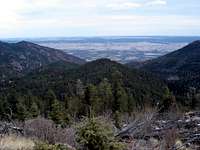 Point 8,846 from Ormes Peak
 Eagle Peak from Ormes Peak
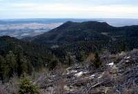 Blodgett Peak from Ormes Peak
Ormes Peak is located in the southern Rampart Range. The two main trailheads for Ormes Peak are Forest Road 302 and the Colorado Springs Blodgett Peak Open Space.
FOREST ROAD 302
Rampart Range Road from Colorado Springs
Forest Road 302 is accessible via Rampart Range Road from the southeast. To access Rampart Range Road from Colorado Springs enter the Garden of the Gods park from 30th Street and proceed around the central garden and follow signs to Balanced Rock. Just before arriving at Balance Rock you will arrive at the intersection with Rampart Range Road. Turn right on the gravel Rampart Range Road. Rampart Range climbs steadily upwards providing great views of the plains to the east. You will pass some huge homes and eventually come to the eye sore that is the Rampart Shooting Range. This is a public shooting range that looks more like a trash dump than a shooting range – I wish more of these people would pick up after themselves. The general idea for the range is it keeps people from shooting at random areas throughout the Rampart Range and concentrates them all at one place – a good thing.
Once past the shooting range things become scenic again with Williams Canyon on the south (left) and Queens Canyon on the north (right). After climbing for several more miles and passing a few scenic lookout points you will arrive at the intersection with Forest Road 301. This is located on the right just past Notch Mountain (9,665’) and is signed for the Eagle Lake Boys Camp. Continue straight on Rampart Range Road for about another mile to the intersection with FR 303. Turn right on the well graded FR 303 a little over 15 miles from the beginning of Rampart Range Road.
Rampart Range Road from Woodland Park
Forest Road 302 is accessible via Rampart Range Road from the northwest. Turn north from US Highway 24 on South Baldwin Street in the City of Woodland Park. South Baldwin Street becomes Teller County 22 and is signed Rampart Range Road. After a few miles the road crosses from Teller County to El Paso County. Shortly after crossing the county line you will arrive at the intersection with Loy Creek Road. Turn right on Loy Creek Road. After a few miles you will come to the intersection with the true Rampart Range Road that passes between Sedalia and Colorado Springs. Turn right on Rampart Range Road. After passing the intersection for FR 306, the access for the Rampart Reservoir dam, you will arrive at the intersection of FR 303 in a little over 6 miles down Rampart Range Road. Turn left on FR 303.
Rampart Range Road to Forest Road 303
In less than one mile you will arrive at the intersection with FR 302. Turn right on FR 302 which quickly becomes severely rutted and passable only to 4-wheel drives with relatively high clearance. You can park at the beginning of the 4-wheel drive section and hike the remainder of FR 302 to the trailhead – this will add one to one and a half miles each way to your hike. Follow FR 302 to the south slopes of Ormes Peak. There is good parking at the Ormes Peak/ Lone Pine saddle on the east side of Ormes Peak but the easiest route up Ormes Peak is via the south slopes.
BLODGETT PEAK OPEN SPACE
The Blodgett Peak main page and the Blodgett Peak Open Space trailhead page have specific directions for getting to the Blodgett Peak Open Space trailhead.
Red Tape
There are no permits necessary for this section of Pike National Forest. The Blodgett Peak Open Space parking lot is technically not open overnight.Weather & Seasons
 USGS directional marker
The FR 302 trailhead may be inaccessible for periods in winter and early spring after heavy snow storms or briefly after heavy summer rains. Check with Pike National Forest for Rampart Range Road conditions.
The Blodgett Peak Open Space trailhead is open year round although heavy snow will likely be present for portions of the route in winter and early spring – particularly the north facing slopes between Blodgett Peak and Lone Pine.
Check local weather here.
Camping
There are several marked campsites in Pike National Forest along Rampart Range Road and the various forest service roads approaching the FR 302 trailhead. There is dispersed camping allowed in Pike National Forest. There are a few pay national forest campgrounds located along SH 67 just north of Woodland Park.There is no camping allowed at the Blodgett Peak Open Space trailhead.
cshanek - Jan 29, 2018 10:57 pm - Voted 10/10
Winter directions and post-Waldo Canyon Fire UpdateA buddy and I spent a Saturday a couple of weeks back bagging Ormes, Lone Pine and Lone Pine N, Blodgett Peak and S Blodgett Peak, and we noted the following: * Apparently regardless of weather/conditions, FR 302 from Garden of the Gods is closed in the winter. We wanted to go this route but had to head up to Woodland Park instead. * Apparently regardless of weather/conditions, you cannot get to FR 303 from Woodland Park, the road is closed. You can park a car at the junction of FR 300 and FR 306, which adds a couple of miles of road-walking to your trip. * With regard to Lone Pine(s) and Blodgett(s), most trip reports mentioned that hugging the ridge and scrambling along is quicker than the bush wack that would be required if you dropped down to the West. Unfortunately the Waldo Canyon Fire cleared just about all of the vegetation in the area (even as of early 2018), so dropping down below the ridge is actually quite quick and easy now.