
-
 14026 Hits
-
 75.81% Score
-
 6 Votes
|
|
Area/Range |
|---|---|
|
|
42.44575°N / 1.93909°E |
|
|
Hiking, Mountaineering |
|
|
Spring, Summer, Fall, Winter |
|
|
9583 ft / 2921 m |
|
|
Overview
I wrote in the page of Pyrenees about the distribution of areas and ranges and I explained as it had two posibilities of areas in Spain or France but Cerdanya / Cerdagne is a strange region because it's now in both countries. It's evident the distribution of the mountains in circle around Cerdanya but it's a little complex politically because the South is in Catalunya (with the provinces of Lleida and Girona) and the North is in France (departament of Pyrénées Orientals with cantons of Saillagouse and Mont-Louis).This area includes the areas of river Segre as Alt Urgell and Cerdanya and the river Llobregat as Berguedá but also some peaks of Capcir or Nuria because they have routes in Cerdanya.
Ranges:
-West: Puigpedrós-Tossa Plana de Lles
-North: Carlit
-South-East: Puigmal
-South-West: Cadí-Moixeró
The massif of Pedraforca is politically out of Cerdanya because it's at South of Sierra del Cadí but I linked the peak as related to the same area because it's very nearby and it appears in some maps.
Getting There
The main village of Cerdanya is Puigerdà but it has another as Font-romeu, Bellver de Cerdanya, Oceja, Guingueta d´Ix, Alp, Llívia or Saillagouse.See bigger map
1. Sierra del Cadí-Moixeró
 Costa Cabirolera
 P. Canal Baridana
 Puig del Quer
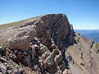 Salt de Sastre
 Costa Cabirolera
Peaks:
-Tres Canaletes (2,608m)
-Puig de las Gralleres (2,617m)
-Vulturó or Puig de la Canal Baridana (2,652m)
-Puig del Quer (2,571m)
-Puig de la Canal de Cristall (2,586m)
-Salt de Sastre (2,593m)
-Pic de la Costa Cabirolera or Roca Punxeta (2,604m)
-Pic del Cabirol (2,443m)
-Punta Aguda (2,458m)
-Puig de la Font Tordera (2,526m)
-Comabona (2,554m)
-Moixeró (2,078m)
-Penyes Altes de Moixeró (2,269m)
-Tossa d'Alp (2,536m)
-Puigllançada (2,409m).
Note for peakbaggers: Costa Cabirolera (2,604m) is the highest point of province of Barcelona and I'll write the page in the next weeks.
Trailheads:
-El Querforadat (1,418m)
-Estana (1,500m), it's an important place because it's the trailhead of the most popular route of the range, the walk-up to Prat del Cadí (1,832m) and it's a very good option to climb to the range across Canal del Cristall.
-Nas (1,225m)
-Pedra (1,120m)
-Riu de Cerdanya
-Urús (1,293m)
-Masella (1,600m)
-Collada del Pedró (1,828m)
-Col de Pal (2,110m)
Refuges: keeped in summer and some week-ends.
North side:
-Refugi Prat d'Aguiló (2,010m): the forest track of 12km from Montellá (1,173m) is narrow but it's possible to drive to the parking under the refuge. Walking from Nas in 3h.
-Refugio dels Cortals (1,610m): forest track from Bellver de Cerdanya or walking from Pedra.
-Refugio Sant Jordi (1,640m): some part of forest track from Bellver or Riu de Cerdanya, the rest is walking.
-Refugi del Serrat de los Esposes (1,511m): forest track from riu de Cerdanya.
South side:
-Refugio Niu de l'Aliga (2,520m): in ski-resort de La Molina near of the summit of Tossa d'Alp. You can use the cable of ski-resort or walking.
-Refugio del Coll de Pal (1,920m): in the road.
-Refugio de Rebost (1,640m): in the road.
 P.C.Baridana
2. Puigpedrós and Tossa Plana de Lles
 Puigpedrós
It's the important area at N.W. of the area around Piuigpedrós (2,914m), the highest point of province of Girona. Some peaks are frontier with Andorra and it has a few of trailheads in the other country.
Peaks:
-Pic de l'Estanyol (2,586m)
-Pic de Fontfreda (2,738m)
-Pic de la Mina (2,683m)
-Pic dels Pedrons (2,715m)
-Pics de Fontnegra (2,879m)
-Pics d'Envalira (2,827m)
-Tosseta de l'Esquella (2,871m)
-Puigpedrós (2,914m)
-Roc Colom (2,686m)
-Peiraforca (2,647m)
-El Castell dels Lladres (2,525m)
-Roc Roig (2,217m)
-Bony del Manyer (2,808m)
-La Carbassa (2,741m)
-Pic de la Portella dels Colells (2,778m)
-Pic de Montmalús (2,782m)
-Pic de Ribuls (2,827m)
-Pic del Pessons (2,864m)
-La Muga (2,860m)
-Tossa Plana de Lles (2,916m)
-Pic de Coma Extremera (2,808m)
-Tossal Bovinar (2,848m)
-Tossal de la Truita (2,752m)
-Monturull (2,761m)
3. Carlit
 Carlit
It's the North zone in French territory in a place with beautiful lakes and peaks with a great mountain, the Pica del Carlit (2,921m), the highest peak of Cerdanya / Cerdagne.
Peaks:
-Pic del Moros (2,137m)
-Roc de la Calma (2,215m)
-Mont Llaret (2,376m)
-Puig del Pam (2,470m)
-Petit Peric (2,690m)
-Puig Peric (2,810m)
-Puig de la Portella Gran (2,765m)
-Puig de la Cometa (2,763m)
-Serra de l'Orri (2,711m)
-Puig de la Grava (2,671m)
-Tossa del Lloser (2,804m)
-Pic del Castell Isard (2,633m)
-Carlit (2,921m)
-Tossal Colomer (2,673m)
-Pic de las Xemeneies (2,878m)
-Pic de Collroig W. (2,833m)
-Serrat del Llops (2,344m)
-Punxó (2,581m)
-Pic de Madides (2,663m)
-Pic d'Estany Faurí (2,702m)
-Puig de las Bacivelles (2,632m)
-Puigpedrós de Lanós (2,842m)
-Pic de Coma d'Or (2,826m)
-Puig de Fontviva (2,673m)
-Llosers (2,664m)
-Puig de Trespunts (2,624m)
-Pic de Querforc (2,585m)
4. Puigmal
 Massif of Puigmal
 Puigmal
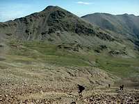 P.de Segre
 Torre d'Eina
 Finestrelles
The massif of Puigmal is frontier with the Vall de Nuria but it has also routes from Cerdanya across the North face.
Peaks:
-Tossa del Pas de Lladrés (2,665m)
-Puigmal or Puigmal d'Er (2,910m)
-Puigmal de Llo (2,801m)
-Pic de Segre (2,848m)
-Pic de Finestrelles (2,829m)
-Torre d'Eina (2,850m)
-Pic de Noufonts (2,861m)
-Cambradase (2,750m)
-Torre d'en Xillèn (2,680m)
-Pics de la Conca (2,722m)
-Roc del Boc (2,774m)
Trailheads:
-Les Esplanes (1,971m): track of ski-resort d'Er Puigmal 2600.
-Coll Marcer.
-Casilla de Saltèguet.
-Col de Segallera (2,185m).
-Eina 2600: ski-resort.
-Eina (1,599m).
-Planés.
The trailhead of South face are in another area: Nuria-Puigmal, but the most frequented is the sanctuary of Nuria with access by train from Ribes de Freser or Queralps.


5. Pedraforca
 Pedraforca
It's not really into Cerdanya but it's very near just at South of Sierra del Cadí and it's a small massif to include it in a new area. The village of Gosol (1,426m) is a trailhead to both ranges, Cadí and Pedraforca.
Peaks:
-Roca Roja (2,037m)
-Pollegó superior (2,498m): it's the North summit of Pedraforca.
-Pollegó inferior (2,436m): it's the South summit of Pedraforca.
Red Tape
The range of Cadí-Moixeró is a natural park with rules.Some ranges have ski-resorts as Eyne 2600, Cambra d'Ase, La Molina, Masella... in the area of Puigmal and they're open in winter.
External Links
Maps:-Rando ed. 8: Cerdagne-Capcir
-Sua ed: Cerdanya
Books:
Cerdanya: sua ed. (spanish).
Webs:
-Rock-climbing Cadí
-Park Natural Cadí-Moixeró