
-
 10208 Hits
-
 83.69% Score
-
 17 Votes
|
|
Area/Range |
|---|---|
|
|
42.83890°N / 0.2903°W |
|
|
Hiking, Mountaineering, Scrambling, Skiing |
|
|
Spring, Summer, Fall, Winter |
|
|
10338 ft / 3151 m |
|
|
Overview
The valley of Tena is a very wide area with the first three-thousands of Pyrenees from the west and a lot of important mountains. It's clasified generally in several massifs or groups: Balaitous, Facha-Piedrafita, Panticosa and Tendeñera.Massif of Palas-Balaitous
 Balaitous
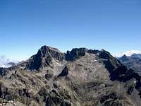
The great peak of Balaitous is the first 3000m of Pyrenees from the west and its ridges are really spectacullar. It's a legendary peak in the history of the Pyrenees but nowadays it's not as difficult as seem thanks to the knowledge of the routes.
Balaitous is surrounded for many great peaks but the most impressive are Palas and Arriel. The south ridge of Balaitous contains the others three thousand of the massif, the peaks of Frondiellas, but they are not so individalized peaks from the distance as the others. In french side are near the peaks of valley of Ossau as Midi d'Ossau or Lurien, but it's not valley of Tena, it's the area of Bèarn (but the landscape it's great with its present).
-Mountains:
Artouste (2816m), Pallas (2974m), Arriel (2824m), Soques (2716m), Foratata (2341m), Balaitous (3144m), Frondiella (3071m), Gavizo-Cristal or Cristales (2890m), Cristayets (2723m).
-Trailheads: embalse de la Sarra (La Sarra's dam) and the Refuge de Respomuso (2h of walk-up from La Sarra). Peña Foratata have trailhead in the village of Sallent or the ski resort of Formigal. The peak Pallas generally is climbeb from the french side in Caillou de Soques across the Refuge d'Arremoulit but it's possible to reach the refuge as well from La Sarra or even to climb the peak in one day (longest but frequented).
Nearest village: Sallent de Gallego.
Approach to Sallent de Gallego:
-From North and West of Spain, N-240 to Jaca, N-260 and A-136 to Biescas, turn to right 5 km to Sallent.
-From South (Huesca, Zaragoza, Madrid…), N-330A to reach N-260.
-From East (Barcelona, Lleida..), N-240 to Barbastro and Huesca to reach N-330A and N-260.
From Sallent to La Sarra take the bad road for 6 km to the dam.
 Pallas Pallas |
 Artouste Artouste |
 Arriel Arriel |
 Frondiellas Frondiellas |
 Cristales Cristales |
 Foratata Foratata |
|---|
Massif Facha-Piedrafita
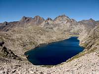
 Cirque of Respumoso
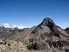
Of all this mountains of this cirque only the peak Facha surpase the 3000 meters but the other mountains are really relevants as well, specially the nice Llana Cantal, the great pyramid over Respomuso. Tebarray and Piedrafita are the peaks at the end of the cirque in the east near of the peaks of Panticosa as Infiernos or Garmo Negro. Some peaks of this area as Piedrafita, Gaurier or Punta Zarra are really unknowns and difficults, it's really impossible to find somenone climb it.
-Mountains : Pic de la Peira St.Martin (2791m), Cambales (2965m), Peña Aragón (2947m), Gran Facha (3005m), Aratille (2900m), Picos de Marcadau (2727m), Piedrafita (2916m), Gaurier (2918m), Punta Zarra (2947m), Llena Cantal (2956m), Campoplano (2727m), Tebarray (2912m), Musales (2654m).
-Trailheads: Refugio de Respomuso (2h of walk-up from dam of La Sarra, see above to approach). The peaks of South-East as Piedrafita or Tebarray has as well trailhead in Balneario de Panticosa.
Approach to Panticosa:
The trailhead is Panticosa's balneary that one finds near Panticosa's village (6 Km distance ).
To arrive to Panticosa there are several options:
-From Zaragoza to Huesca (72 km), highway. From Huesca or Jaca take direction to Sabiñanigo (point of entry to valley of Tena) and continue to Biescas. From here it's easy to Panticosa or Sallent de Gállego to sleep. In the morning you must to go to the Panticosa's balneary to begin the climb.
-From Barcelona: highway A2 to Lleida (or Lérida). From Lleida you'll must to take the N240 in direction to Binefar and Monzón and you'll follow the indications to Panticosa.
 Pic de la Peira Pic de la Peira |
 Facha Facha |
 Cambales Cambales |
 Llana Cantal Llana Cantal |
 Marcadau Marcadau |
 Tebarray Tebarray |
|---|
-Estaing-Barbat: not really in Tena's valley but is the little valley in french territory of north.
-Mountains: Gran Barbat (2813m), Midi d'Arrens (2267m), Arrouy (2785m), Peyregnets (2822m).
Area of Panticosa
 Massif of Argualas
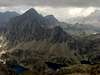
Important area with Panticosa resort and balneary. The trailhead most frequent is in Balneario de Panticosa for the majority of the mountains.
-Mountains: Picos del Infierno (3082m), Arnales (3006m), Garmo Negro (3051m), Algas (3021m), Argualas (3046m), Serrato (2888m), Batanes (2888m), Baciás (2760m), Brazato (2734m), Baldairán (2701m).
-Trailheads: Balneario de Panticosa (see above to approach). The peaks of area of Baldairán has as well trailhead in parking of Bolatica (1km from the village of Panticosa in direction to Balneario de Panticosa).
 Garmo Negro Garmo Negro |
 Infiernos Infiernos |
 Infiernos Infiernos |
 Serrato Serrato |
 Batanes Batanes |
 Batanes Batanes |
 Baciás Baciás |
|---|
Tendeñera's Range
 Tendeñera's range
The long range of Tendeñera is the southest range of the valley and it has spectacullars walls and rocky ridges.
-Mountains: Peña Roya (2589m), Sabocos (2757m), Mallo las Peñas (2662m), Forato os Diaples (2715m), Ripera (2835m), Tendenera (2853m), Otal (2709m), Fenés (2524m).
-Trailheads: -north from village of Panticosa (in the parking of ski resort) to the summits of West side (Peña Roya, Sabocos) and from the valley of Ara-Bujaruelo to the summits of East side (Otal).
-south: Yésero, Linás de Broto (Tendeñera).
 Peña Roya Peña Roya |
 Sabocos Sabocos |
 Diaples Diaples |
 Ripera Ripera |
 Tendeñera Tendeñera |
 Otal Otal |
 Fenés Fenés |
|---|
Diego Sahagún - Aug 3, 2009 5:14 am - Hasn't voted
La Marcha, caminata histórica entre Francia y Españahttp://desnivel.com/object.php?o=18807