
|
|
Area/Range |
|---|---|
|
|
42.68900°N / 0.01600°E |
|
|
Hiking, Mountaineering, Trad Climbing, Ice Climbing |
|
|
Spring, Summer, Fall, Winter |
|
|
Overview

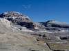
The National Park of Ordesa and Monte Perdido was the second National Park to be created in Spain, back in the beginning of the twentieth century. On the other side of the border stands the french National Park of the Pyrenees, making this area one of the most closely protected by legal regulations of both countries. It surely deserves to be so. The structure of the area is centered on two main points: the high limestone massif of Monte Perdido (together with its neighbours Cilindro and Añisclo) and the Vignemale Massif, with the biggest glacier you can find nowadays in the Pyrenees. A beautiful ridge covers the distance between them, marking the border between Spain and France and offering some three-thousanders of its own to be climbed. Some beautiful valleys are the highways to enter this wonderful world of summits. Ordesa and Pineta are typical glacier-origin valleys, placed west and east of Monte Perdido. Añisclo Canyon could be considered to be somewhat of a mixed origin valley, offering a very long approach to the south side of Monte Perdido massif but also beatiful sights. The Ara Valley runs west-northwest from the entrance of the Ordesa Canyon and surrounds the whole Vignemale Massif before reaching the distant cirque of the Ara and joining the Panticosa sector.
Las Tres Sorores - Monte Perdido and its neighbours

Three main summits: Monte Perdido(3355 m), Cilindro de Marboré (3335 m) and Añisclo /Soum de Ramond (3234 m) form this limestone range once considered as the highest mountain in Europe. This is where some of the first steps of Pyrenees climbing took place. Additional summits can be found southwards, forming the smaller range known as "Las Tres Marías".
Three main accesses to the area can be considered: Ordesa Valley, the Añisclo Canyon and the Pineta Valley. The only chances for lodging (apart from nearby villages) are the Góriz Hut and the Parador Nacional de Monte Perdido (at the end of the road in the Pineta Valley).
Main summits: Monte Perdido, Pico de Añisclo/Soum de Ramond, Cilindro de Marboré, Punta de las Olas.
Other (lower) summits: Torre de Góriz, Las Tres Marías.
 |
 |
 |
The border ridge

West of the Monte Perdido Massif, and linked to it by the summit of Marboré, you can find a ridge stretched along the border between France and Spain and reaching the Col de Boucharo (puerto de Bujaruelo in spanish maps). The summits along this ridge include the three Picos de la Cascada, La Torre, El Casco, Punta Bazillac, Taillon and the Gabietous. There is also the spectacular sight of the Brecha de Rolando and north of all these peaks the terrific views over the deep Cirque de Gavarnie. Access is made by the road between Gavarnie and the Col de Boucharo (puerto de Bujaruelo) or via the Ordesa Canyon. Consider seriously the possibility to stay overnight at the Góriz Hut if coming from Spain, for most climbs are quite long in this area when coming in from the south. The french side is served by the réfuge de Sarradets (on the north side of the Brèche de Roland).
Main summits: Taillon, Marboré, Casco, Torre, Picos de la Cascada, Gabietos / Gabiétous.
Other (lower) summits:Pico Blanco, Punta Bazillac.
 |
 |
 |
The valley of river Ara and the Vignemale Massif
 Vignemale North Face
 Glacier d'Ossoue
The Vignemale massif forms kind of a fortress placed in the french-spanish border, towering over the valleys of Ossoue, Gaube and Ara. It was first conquered by its south face, by a certain Lady Lister who came from England in the 19th century and hired her guides in the french villages around the area. She was opening the door to a wonderful world of three-thousanders and ice, forming the first group to set foot on the ice of the second biggest glacier of the Pyrenees. The duke of Moskowa was in the second summit party some days later, and count Henry Russell closed the list of the pioneers when -after falling in love with Vignemale- he rented the mountain from the french.
Nowadays the north face offers impressive climbing, the glacier of Ossoue makes for some of the best ice practice in the Pyrenees and the valley of Ara means a wonderful hike for miles of almost deserted mountain landscape, walking around the huge rocky fortress.
The main refuges serving this area are the réfuge des Oulettes de Gaube (France), Bayssellance (France) and Bujaruelo (Spain).
Main summits: Grand Vignemale, Petit Vignemale,
Other (lower) summits: Grand Tapou, , Clot de la Hount, Pointe Chausenque
 |
 |
Other summits and attractions in the National Park
 Punta Tobacor
Pico del Descargador
Punta Custodia
Punta Acuta
Punta Tobacor
Mondarruego
Pic des Ligades
 Punta Custodia
Mainly small easy peaks, placed between the valleys and around the bigger mountains. Some of them offer fine views of the area. A visit to the cirque of Gavarnie is also a must, check the child page maintained by Rick B. The Grande Cascade is the highest waterfall in Europe, and that does deserve a look...
National Park Regulations
The main regulations to be enforced on the spanish side of the border (Real Decreto PRUG 409/1995)are the following:- Free camping is forbidden. It's permited to vivy or camp using a tent lower than 1.3 m/ 4 ft 3.25 in, wich would be taken down at dawn. This practice is allowed above these heights:
Ordesa area: 2.100 m (Clavijas de Soaso)
Añisclo area: 1.800 m (Fuen Blanca)
Escuaín area: 1.800 m (La Ralla)
Pineta area: 2.500 m (Balcón de Pineta / Bolán de Marmorés)
- Sports aside hiking, climbing, ski-mountaineering and speleology are forbidden.
- The sale of commercial products is not allowed
- It's forbidden to swim in the rivers, streams and lakes
I haven't got any information right now about the french national park regulations, but they should be (at the very least!!!) similar to the spanish ones
visentin - Jan 19, 2011 9:00 am - Voted 10/10
Geography :)Hi Eza ! I am rewritting the Bigorre page and I noticed few things that could be improved about the structure. Here it's about the name. I think it would be better to rename this area "Pirineos: Monte Perdido - Ordesa", instead of "Gavarnie" in the name. Despite the 3000 peaks are on the border, the Cirque of Gavarnie is more on the french side and in the Bigorre page. However, I see no problem about the page of sub-range of Gavarnie (by Rick B) remaining attached here. What do you think ? :) Thanks ! Eric
eza - Jan 19, 2011 1:51 pm - Hasn't voted
Re: Geography :)Agreed, Eric. As a matter of fact, this area page is an old one and I seem to remember it was written long before the Bigorre page, but you're right: the Cirque of Gavarnie belongs to Bigorre. Therefore, I'm renaming the area and deleting the "Cirque de Gavarnie" from one of the page sub-headings. Thanks for the message. P.S: Do you think it would be OK to leave the "Border ridge" section to include all those 3000ers between the Gabiétous and the Marboré?
visentin - Jan 20, 2011 2:21 am - Voted 10/10
Re: Geography :)Thanks ! I guess the idea at the origin was to create an area about the whole perimeter of the Perdido range on each side, and then the subdivisions by countries abd sections was implelented afterwhile. The philosophy that Rafa explained me is that each peak that belong to two areas (let's say, who owns trailheads in several areas) must be attached to each of them. For the Ordesa-Gavarnie ridge, it is obvious that they (Marboré, Taillon, etc) must remain attached ! ;) Thanks ! Eric