-
 11718 Hits
-
 83.69% Score
-
 17 Votes
|
|
Mountain/Rock |
|---|---|
|
|
43.45519°N / 109.78781°W |
|
|
Hiking |
|
|
Summer |
|
|
11491 ft / 3502 m |
|
|
Overview
The Wind River Range. Those who have been deep into it speak of it with reverence. Those who have never been there at all find themselves allured by its reputation. A backpacker's paradise. A climber's Utopia. Superlatives and hyperbole dominate discussions of it, and they are justified. The most truly alpine range of the U.S. Rockies, it is a realm of high peaks, sparkling lakes, glaciers, endless vistas, and the wildlife that makes Wyoming, well, Wyoming.
But Union Peak is not one of the postcard peaks that are on so many lists and in so many pictures.
Union Peak is several miles from the high, glaciated heart of the range, but the summit provides views to those distant peaks as well as to the mountains around Green River Lakes. The entire north-south expanse of the Gros Ventre Range is visible, as are much of the Tetons. To the north are the southern peaks of the Absaroka Range, and views extend over alpine plateaus to the most remote peaks in the Lower 48-- Younts Peak and Thorofare Mountain.
What's in a Name
Union Pass, 9210' and on the Continental Divide, is commonly considered to be the northern end of the Wind River Range. If so, then Union Peak, about five miles southeast from the pass, is the last and northernmost peak in the range on the Continental Divide and almost the northernmost peak in the entire range; only the summit of Windy Mountain is more to the north, and just slightly so.
The pass was named in 1860 by William F. Raynolds, a captain in the U.S. Army. Raynolds was in charge of an expedition exploring the Yellowstone area, and after legendary mountain man Jim Bridger led the group over the pass, Raynolds gave it its name. The Raynolds expedition was not the first to discover or cross the pass, though; it had been in use for over half a century already by mountain men and had been crossed going back much earlier by Native Americans.
I do not know if Raynolds named the peak as well. The first recorded ascent was in 1878 by Orestes St. John, but it would not be surprising to learn that Native Americans had ascended this peak long before while pursuing herds of elk and bighorn sheep.
Climbing Overview
"Climbing" Union Peak is an easy Class 2 hike that ascends about 2300', not counting some minor ups and downs, in about 5.5 miles. The easiest way appears to be from Union Pass, and details and suggestions will be provided in the next section. The mountain also appears to be climbable from the north, in less distance, from a 4wd road that crests at a little over 10,000', but I do not know anything about access or road conditions.
It is not the world's most exciting hike, but there are beautiful tundra meadows, and the peak's isolation from other peaks allows sweeping views of northwestern Wyoming's spectacular high country.
Getting There and Route Information
Getting to Union Pass
To reach Union Pass, drive west out of Dubois on U.S. 26/287 for 8 or 9 miles and, just after a bridge over the Wind River that puts the river on your right, turn left onto a road signed for access to Union Pass. Drive this good dirt road, easily passable to most passenger vehicles, for about 14 miles to the pass, which is long and broad, with the crest perhaps not obvious. However, the pass is on the boundary of the Shoshone and Teton National Forests, and that boundary is clearly marked and easy to see. There is also a fence running in both directions from the road.
You can also reach Union Pass from the south by turning north from U.S. 191 about five miles west of Pinedale. This approach is much longer, and I have heard that it is more rugged, but I have never driven it.
Ascending the Peak
The obvious thing to do seems to be to follow the line of the Divide all the way to the peak. However, there is boggy terrain to cross at first, and, as stated before, the Divide is very broad here. You could easily find yourself off the right track. While you will not get lost, you will add time and exertion to your outing.
A better way is to follow the rugged Seven Lakes Road for some distance and then follow the Divide where it is more obvious all the way to the summit. 13.2 mi from 26/287, look for this road on your left. There is a stream crossing almost immediately, and if you do not have high clearance, park here without blocking the road. With high clearance, if the water is low enough, drive across the stream and drive the road as far as your vehicle can handle it (it is very rocky and steep in places, and I would rate the road as moderate), up to 2.4 mi from Union Pass Road (in a Dodge Journey, with all-wheel drive instead of true four-wheel drive and not very impressive ground clearance for an SUV, I was able to get 1.5 mi up the road before it became too rough for that vehicle; in my own Nissan Xterra, I could have made the full 2.4 mi with very little trouble). There, the road crests a 10,300' knob before dropping steeply to a stream crossing.
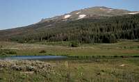
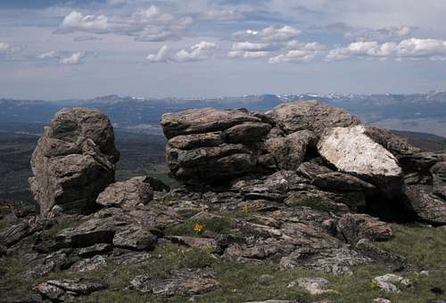
Park at this crest, where Union Peak is fully visible, and then follow gentle ridges and/or meadows 3.1 mi to the summit, where there is a massive cairn and a massive register tube. You will first go over a knob at about 10,500' (mislabeled on maps with 10,194' near its summit) and then drop a short distance, and then it is all up to the top. There is nothing terribly remarkable along the way, but two things are worth mentioning: descending the knob, you may come across an alpine pond framing a nice view of Union Peak; and near the summit, there are several interesting rock outcrops that make nice photo subjects and could be fun to play around on.
A Shorter Variation
Instead of parking at the 10,300' knob, continue along the road for another three miles or so if your vehicle can handle it. The road will climb to 11,000' and be less than a mile from the summit. Actually, the road climbs to 11,400 at a point about 1.5 mi southeast of the summit, making for a "climb" of less than 100'. If you have the vehicle for it and the summit is all that matters to you, this is obviously the way to go. However, if you have had to hike in, this is not a good route because it will be longer than the one described above and will have more overall elevation gain.
Red Tape, Camping, and Lodging
Grizzlies are known to inhabit the area. Know your bear etiquette before you go.Dispersed camping is widely available.
If you don't want to camp, Dubois has plenty of motels. Should you prefer a bed but want to get away from town, you could consider the Lava Mountain Lodge, which is between Dubois and Togwotee Pass. In 2001, I stayed there when it had a different name and was under different ownership, and it was a nice place to stay. Although I have not stayed there under the current management, I have stopped there a few times for gas, snacks, and drinks, and the staff has always been very friendly.
But if you really want to get away from town, experience the scenery, and enjoy top-rate food and lodging, look into the Absaroka Ranch, up the Du Noir Valley. It caters more to groups and extended trips, but if you are out here for a week or two, this could be a really nice option. SP member Doublecabin works there, and his family owns the ranch. I was fortunate enough to be a guest there for three nights in August, and I can say that the scenery is amazing, the food is great, and the people are very friendly.


