
|
|
Mountain/Rock |
|---|---|
|
|
45.46160°N / 14.46780°E |
|
|
Hiking, Scrambling, Canyoneering, Skiing |
|
|
Spring, Summer, Fall, Winter |
|
|
4514 ft / 1376 m |
|
|
Intro
Obruc (1376m) (should be read Obruch) is sweet little mountain placed at the NW edge of Gorski Kotar mountainous region above North Adriatic. Gorski Kotar is part of Dinaric Alps. Together with Slovenian Slovenski Sneznik it is placed on their NW end and is generally viewed as the beginning of Dinaric Alps. On quite a small area (15x10km) there is lot of diversity, quite enough even for much larger mountain. Obruc has several very interesting and beautiful natural attractions; soft and nice grassy southern slopes, which are full of flowers in spring, deeply cut Mudna Dolina valley and its fantastic canyon, Pakleno area with heavily developed karst phenomenon and so on. When you combine that with splendid views result is worthy mountaineers goal. |  |  |
Overview
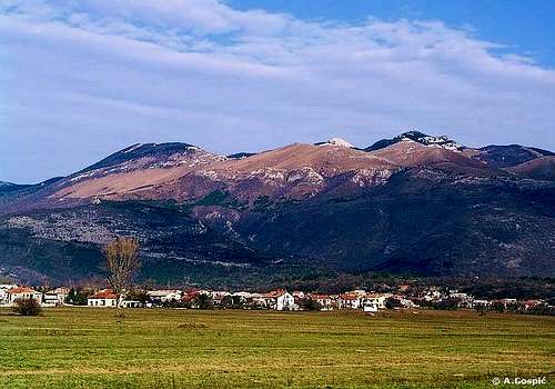 Obruc from Grobnik
Geography. On the S is Grobnicko Polje (Grobnik field, 300m). More about it find below in separate section. Lower third of Obruc above the field is forested by oak and pine forests while upper two thirds are soft and long grassy slopes, which are beautiful, in spring full of flowers. Above them are three grassy cones: Cunina Glava (1158m), Dnic (1190m) and Vidalj (1184m). From Grobnik two deep valleys cut into the body of Obruc: Borovica and Mudna Dolina. Borovica valley got its name after beautiful pine (bor) forests which used to grow in it. Unfortunately it is no more. Barbecue fire of reckless group of people ended with inferno which in summer of 2003 swallowed it all. Now valley is black disaster area. MUDNA DOLINA valley is one of highlights of Obruc. It is cutting deep into the body of Obruc in N-S direction. Upper half is shallow and grassy with beech groves. As it descends valley gets deeper all the time. Finally lower half turns into fantastic canyon whose sides are few hundred meters high, made of broken cliffs and scree. Bottom of the canyon, which is dry, is so narrow, on spots less than 1m! Valley and canyon abruptly end at the edge of Grobnik field. Mudni Potok creek rarely flows through valley, only after heavy rains or sudden snow meltdowns. It is impassable then.
On W Obruc descends towards Klana karst plateau which is at altitude of around 400-500m. This side of mountain is dominated by massive Obruc (1376m), which is also highest peak of mountain. South of it is grassy Cunina Glava (1158m). In the western foothills of Obruc is source of Rjecina river.
On the N Obruc gradually descends towards high lying Trstenik and Gomance valleys (around 1000m) of which last one separates it from Slovenski Sneznik (1797m), highest peak in Slovenian Karst, which is some 13km to the N. This area is under dense beech, spruce and fir forests. Northern most peak of Obruc is Trstenik (1240m).
On the E Obruc is connected with Gorski Kotar mountainous region and is its integral part. Eastern group of peaks is also a border towards Gorski Kotar. It is made of Sljeme (1263m), Grles (1332m), Gornik (1320m), Crni Vrh (1335m), Klek (1214m), Jasenovica<1338m), Nebesa (1131m) and Klek (1067m). Most of these peaks are very nice rocky cones which stick out of forests which surround them. Eastern group is separated from central part of the mountain by Mudna Dol valley and Previjak pass.
Most beautiful and most interesting to mountaineers is Central part of Obruc which is placed north of soft grassy southern slopes and Mudna Dol valley. Heart of the mountain is PAKLENO area or Hell which is surrounded by highest peaks of Obruc. Together with Mudna Dol, Pakleno is biggest attraction of mountain. It is almost impassable area of heavy karst which is true ‘hell’ of torn cliffs, funnel-shaped holes, chasms and caves, all of which is partially covered with beech, spruce and fir forests. From the S Pakleno is closed by Suhi Vrh (1280m) (Dry peak) and Fratar (1353m), which is probably most beautiful peak of Obruc, also has best panorama. Both peaks are very interesting bare rock cones which stick out of forest. On the summit rocky there is some dwarf pine. As both tower above grassy southern slopes of Obruc they offer fantastic views towards sea and Gorski Kotar region. With its long summit ridge Obruc (1376m), highest peak of Obruc, closes Pakleno from W. On the N is Burni Val (1340m) while on the E is Osoje (1338m). All peaks fall very steeply towards Pakleno. Inside Pakleno is also Pakleno (1305m) peak with nearby Bucov Plato over which crosses circle trail through the area. Bucov plato is weird rocky summit that looks like plateau but is actually made of numerous rocky towers. In the middle of Pakleno is interesting Napa (range-hood), huge rock block which towers above forest with broken or smooth limestone cliffs. To its summit lead two climbing routes for mountaineers.
It is easy to say that Obruc is one of most beautiful parts of Gorski Kotar and certainly has best views towards sea. Mountain is well visited because of nearby Rijeka city, which is placed on the coast. Hahlici hut is small so reservation is necessary. Kamenjak mountaineering club from Rijeka arranged on Obruc a hiking trail whose check points are most interesting part of the mountain. It has very interesting name; Kroz Pakleno do Nebesa which means Through the Hell to the Sky. Pakleno is central area of the mountain while Nebesa is peak on SE end. Marked paths which are part of the trail have H letter by the mark. One can buy diary of the trail in Hahlici hut. 3 days are least one needs to visit all the check points, which are equipped with seals, but time is not restricted.
Obruc mountain doesn’t only have natural trademarks. Hahlici hut has certainly become one as is Davor Supak, its legendary manager or care-taker. Davor is 73 years young and during his 23 year long carrier as manager he only missed 3 weekends!! That is a unbelievable working record when you think that every Friday he climbs up and in Sunday descends back to his village. One has to wonder during what kinds of weather he has climbed the mountain. In 2002 Davor was named Croatian hut manager of the year. He deserved it earlier if you ask me. As its name says Hahlici hut is placed on Hahlici, place at the edge of forest on top of southern grassy slopes, in the valley between Dnic and Cunina Glava. It is a name of few ponds which are minute below hut. On this place there where springs of water. 3 centuries ago shepherds made a wells of them but till today only ponds remained. Because of popularity of the place and hut Hahlici name has become synonym for whole mountain so today you can rarely hear that someone says ‘we are going on Obruc’ but ‘we are going on Hahlici’. Lets go.
 |  |  |  |
Views
 View towards Kvarner
Views from Obruc are fantastic. It is placed on the W edge of Gorski Kotar region, pushed close to the sea and is its best viewpoint. Naturally sea views are highlight of Obruc panoramas.
S: below soft grassy southern slopes of mountain is Grobnik field. Behind it, over lower ridges, is coast of North Adriatic sea or Kvarner bay. Most of bay is occupied by large Krk (568m) island. Right of it is Cres (650m) island. Far on the south, above southern most part of Cres, summit of Losinj (589m) island sticks behind. Left of Krk, far behind, is wall of Velebit mountain. To be precise that is North Velebit with Senjsko Bilo, Zavizan and Rozanski Kukovi groups.
SW: in this direction eastern coast of Istra peninsula stretches. Above its northern end dominates Ucka (1401m) mountain.
W: Cicarija (1272m) mountain.
N: close neighbor of Obruc is Slovenian Slovenski Sneznik (1797m). Around it is Slovenian karst. Far on N are Julian Alps with their highest peak Triglav (2864m). Towards right is Karavanke range, also in Alps, with their highest peak Stol (2236m). Further right are Kamniske Alpe with Kocna (2540m) & Grintovec (2558m).
E & SE: is reserved for Gorski Kotar mountainous region which looks like undulating sea of peaks.
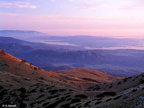
 Obruc sunset
 |  |  |
Around Obruc
Grobnik field is a typical karst plateau or field, which are so frequent is Dinaric Alps, surrounded by mountains. Altitude is around 300m while dimensions are 5x3km. On the field there are several villages, race track and runway. Largest village is Drazice through which road leads to the foot of Obruc. By the SE edge of the field runs Rijeka-Zagreb highway. Field is grassy with some oak and pine groves. In the middle of the field is Hum (396m) hill which splits it in two parts. Scenery around Grobnik is very nice. Mountains (also called Grobnik Alps) rise from all but SW side towards sea where barrier is much lower, rising only 150m above it. On top of it is well visible Grobnik town, a church and fortress with village below. It is nice panoramic spot from which is beautiful view of Grobnik field and mountains behind it. On the other side view expands towards sea and islands. Podkilavac village, trailhead for southern Obruc approaches, is placed on the NW edge of the field.Rjecina river springs in the western foot of Obruc mountain, at the altitude of 325m and is 18km long. Rjecina is typical karst river, heavily dependant on precipitation. Its waters are clear but during longer droughts it can dry out. Around its mouth, today third largest Croatian city, Rijeka was established. On its way towards sea Rjecina furrowed, in limestone and dolomite layers, picturesque gorge which is deepest at the back of Rijeka where it is more than 100m deep. Source of Rjecina can only be reached on foot. Last village accessible by car is Kukuljani from either Grobnik or Viskovo.
Gorski Kotar is mountainous region between North Adriatic, on the west, and hilly region which later melts into central Croatian lowlands, on the east. On that stretch Gorski Kotar is around 50km wide. Obruc is its integral part, placed at NW edge. Its northern border is state border with Slovenia. Unclear is its southern border. Question is are Velika Kapela and portion of Mala Kapela mountains part of Gorski Kotar or not. There is no consensus on this question.
Values of Gorski Kotar are numerous. It is largest forested area in Croatia. Since average altitude of region is around 800m most predominant are beech, spruce and fir forests. Gorski Kotar is region of several mountains, thousands peaks and ridges, caves, numerous valleys and creeks. There are several rivers and gorges, also waterfalls. Climate is mountainous which means quite harsh and fresh. Gorski Kotar receives lot of precipitation, in winter snow so there are several small ski centers. Highest mountains are Bjelolasica (1534m), Risnjak (1528m) and Snjeznik (1505m). In villages authentic architecture has been preserved. Tourist and hiking possibilities in Gorski Kotar are endless and would need its own gigantic page to be described in detail. Hopefully with time its most important mountains and peaks will get their own pages.
Hike Advices
 On the 'Kolci' route to Potkilavac
Obruc is interlaced by numerous marked trails which offer as many combinations. Best combination is to ascend via Mudna Dolina because of its fantastic canyon. Don’t save this route for descent because of some for descent tough climbing sections where it would be best to rappel. Up goes smoothly. Sleep over in Hahlici hut and visit most beautiful parts of highest part of the mountain. Descent via normal southern route. If you are in hurry but would like to visit Obruc it is important that days are long in that part of the year. You can do 2day combination in a day but you must be in very good condition because that is quite difficult task.
2 day visit: leave car in Potkilavac village and approach Hahlici hut via Mudna Dolina valley. If you have 2-3 more hours to spare till night climb Obruc (1376m) in the afternoon and sleep over. On the 2nd do circle through Pakleno, then climb both Suhi Vrh (1280) and Fratar (1353m). Later in the afternoon descent to Potkilavac via Normal route (by the Ceka).
Extended Trip: combine Obruc with nearby Snjeznik (1505m) and Risnjak (1528m). This is much tougher than previous combination but doable for those in good shape and this way you get to see some of most beautiful parts of Gorski Kotar in same trip. On the 1st day reach Hahlici hut through Mudna Dolina valley. In the afternoon do Pakleno circle and climb Obruc (1376m). On the 2nd day climb Suhi Vrh (1280m) and, or only, Fratar (1353m) before continuing towards Platak which is below Sneznjik. From Platak Snjeznik (1505m) is close. Sleep over in the hut at the summit. On the 3rd day from Snjeznik continue towards Risnjak (1528m). Return to Potkilavac via Platak.
 |
Getting There
Trailhead to visit Obruc mountain is Podkilavac village at its southern foothills. Center of the region is Rijeka. Once in Rijeka you will take a local bus to Podkilavac village (more than 10 times per day). If you are by car and approaching via Trieste or Ljubljana once in Rijeka follow Zagreb direction. If you are using highway get off on Cavle exit. Same goes if you are coming from Zagreb direction, you’ll exit at Cavle. Once in Cavle follow Drazice direction. In front of the post building in Drazice is rotator on the road. Take first right turn towards Podkilavac. There is no sign so if you are not sure ask someone. Podkilavac is at the edge of Grobnik field and road passes through the village. Behind last houses is very narrow bridge over a dry creek bed. Park a car behind it.By Plane
Closest airport is Rijeka airport on Krk island, some 25km from center of the city and around 30km from Podkilavac. But airport is used only for special purposes since it is quite close to Zagreb international airport. Once in Zagreb you’ll have to switch to bus or train. Look for time tables at Croatia Airlines site.
By Bus
There are numerous bus lines from Zagreb to Rijeka each day. Detailed bus timetables from Zagreb to Rijeka you can find at Zagreb bus station site.
By Train
There are several trains departing from Zagreb to Rijeka each day. Train timetables can be found on Croatian railways site.
By Car
There are three main directions which are approaching Rijeka from central Europe, via Trieste, Ljubljana or Zagreb.
From Trieste (Italy)
This direction is suitable if you are coming from western Europe
~ Trieste – Rijeka: 70km
From Ljubljana (Slovenia)
This direction is suitable if you are coming from central Europe
~ Ljubljana – Postojna – Rijeka: 122km
From Zagreb
This direction is suitable if you are coming from eastern Europe via Budapest (Hungary)
~ Budapest – Zagreb: 347 km
~ Zagreb – Rijeka: 170km
Look for current road conditions in Croatia on the page of Croatian Automobile Club (HAK)
Maps
Because of true labyrinth of marked paths map is necessary on Obruc or one might quickly lost orientation and clue where paths from all those junctions lead. On all described routes every junction is mentioned to make it easier somehow. I guess members of Kamenjak club from Rijeka realized that there is simply too many marked paths so they intentionally neglected few of the marked routes in the central part of the mountain, around Pakleno area. On them marks almost vanished and are extremely difficult to follow. Which paths are in such state is also mentioned in routes descriptions. |  |  |
When To Climb
Winter: Obruc is pushed towards the sea so it has little bit milder climate than central Gorski Kotar. Snow is frequent in winter and top of the mountain is generally covered by it from December till April. But during longer sunny periods when high pressure settles on exposed southern grassy slopes snow can melt. But once you enter forests and Pakleno area on top of mountain behind be sure to find snow so crampons are necessary. Most dangerous factor in winter is Bura wind.Spring: on Obruc is beautiful, especially May when everything is fresh green and grassy slopes covered with flowers. April is transition month between winter and spring when grass is still yellow and forest bare while snow generally retreated from southern slopes. June is already hot.
Summer: June can easily be considered as first summer month. During peak summer in July and August southern slopes are very hot and exposed to sun whole day. But in deep forests of high part there is always plenty of shade.
Autumn: September is transition month between summer and autumn. Grass is yellow while forests is still green. Temperature are cooler than in summer. Best and most beautiful month is October when beech forests are painted in warm colors. November is transition month between autumn and winter when usually there isn’t snow on the ground, but can easily fall, and forest is bare.
Conclusion is that best months to visit are winter months if you like snow fun. Outside that period definitely May and October.
Mountain Conditions
There is no meteo station on Obruc. Below the mountain, on the coast, is Rijeka city which will provide accurate forecast, except temperatures. On top of Obruc temperature is generally at least 8°C lower. On DHMZ (Croatian Meteorological and Hydrological Association) site there is 7 day forecast for Delnice town which is in the heart of Gorski Kotar. Unfortunately no current data is given except snow depth when there is some. Zavizan meteo station on Velebit mountain is some 100km towards SE. It provides good high altitude picture but is quite higher than Obruc. It can be expected that temperature on Obruc is around 3-5°C warmer. Snow depth cannot be compared, Zavizan receives more.WeatherOnline:
WeatherOnline home page
Croatia at WeatherOnline. You can find Rijeka there.
Zavizan at WeatherOnline
Croatian Meteorological and Hydrological Association (DHMZ):
DHMZ home page
DHMZ Forecast page
DHMZ 7 Day Forecast for Croatian cities and places World wide, including Rijeka and Delnice
Current Weather Conditions in Croatia including Zavizan and Rijeka. Zavizan reports weather between 04-14h & 19-21h. In summer it is 1h+.
Snow Depth's in Croatia
Objects
Hahlici hut (1097m) is placed on southern slopes of Obruc, at the top of grassy slopes and edge of the forest. It is small wooden object which can accommodate up to 15 people. On the ground floor are kitchen, dining room and bedroom with 6 places. In the loft are three more rooms 10 places. In summer season hut is open everyday, except Monday and Tuesday, while in the rest part of the year during weekends. It is managed by legendary Davor Supak. More about him I wrote in ‘Overview’ section. He prepares one dish per meal whether you like it or not but I’m sure you would :-) If he is in the mood maybe he’ll fulfill your wish and prepare some other dish for you. Hut is property of ‘Kamenjak’ club from Rijeka. From the terrace is beautiful view towards Grobnik field, sea and Krk island. First hut on this position was opened in 1926 but was burned in WW II. New object was build on the foundations of old one and opened in 1968. |
Camping & Accommodation
On Obruc there is plenty of space to erect a tent. It is good to have it at hand if you don’t have a reservation for the hut because of its small capacity. If you find a place in the hut you can leave it there while on trips.If you need to sleep in the area before climbing Obruc mountain here are few links which might help you to find your accommodation.
Rijeka city tourist info, accommodations and surroundings
Kvarner bay region: cities, places, islands, mountains
Adriatica.net online searching & booking site for Croatian coast and wider
stamario - Jul 14, 2007 1:59 am - Voted 10/10
web pagesweb page of the mountain association which taking care of the mountain hut an paths and everything on that mountain area. They started with a reconstruction of mountain hut on that link you can see how it looks.The pages is on Croatian language but soon there will be site on english LINK