
-
 11980 Hits
-
 74.01% Score
-
 4 Votes
|
|
Mountain/Rock |
|---|---|
|
|
37.93070°N / 107.4933°W |
|
|
Hinsdale |
|
|
Hiking, Mountaineering, Scrambling |
|
|
13542 ft / 4128 m |
|
|
Overview
Whitecross Mountain is a mid-range 13er found in the San Juan Mountains of Colorado adjacent to Handies Peak.Here are some meaningful statistics about Whitecross Mountain:
Colorado Rank: 222nd highest
Prominence (ft): 562 ft
Omnidirectional Relief and Steepness: 198m
Isolation (miles): 1.37 miles
Whitecross is generally climbed in conjunction with Handies Peak:
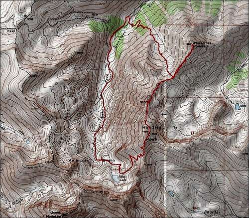
Topo map of the Handies-Whitecross traverse.
Getting There
From Lake City, drive 2 miles south on Colorado 149 and turn right on the Lake San Cristibol road (County Road 30). Follow the signs to Cinnamon Pass. Drive about 20 miles to a signed fork in the road. Left is to American Basin and right is to Cinnamon Pass. Turn left. Be careful to find this intersection as it is not easy to find, especially when dark. If you do not have a 4WD vehicle with good clearance, park in the pull-offs near the start of this road. It's 0.9 mile to the trailhead from the start of the American Basin road. After 0.2 mile, you must cross a stream. There is more parking in this area. At the end of the road, the trailhead has a large parking area and the trail leading to Handies (and eventually Whitecross) is obvious.Alternately, you could start climbing directly up to Whitecross from the road below; however, you will cross private property, so permission should be obtained before venturing that way.
Safety
Before climbing any mountain in Colorado, it is important that you read up on safety precautions.I've written a fairly detailed article outlining that HERE.
Generally speaking, one of the things you need to be aware of is storms and lightning.
Camping
Great camping is available all along the road through the American Basin.External Links
Send me links to any trip reports you have on Whitecross and I can add them to the page.HERE is my trip report.