
|
|
Mountain/Rock |
|---|---|
|
|
51.60410°N / 4.95972°W |
|
|
Pembrokeshire |
|
|
Trad Climbing |
|
|
Spring, Summer, Fall, Winter |
|
|
131 ft / 40 m |
|
|
Overview
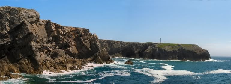
Although often overshadowed by their neighbouring headlands, the cliffs between Mewsford Point and The Castle offer a number of interesting propositions for those who climb in the mid to high grades. Blockhouse Buttress forms one such cliff and is home to a number of enjoyable multi-pitch climbs which reach some 60 metres in height. The routes are fun and steep with excellent rock on the lower pitches, which slightly declines in quality higher up the cliff. The buttress can be identified by a large landward slanting slab at its base and it is from this slab that most climbs begin. The base of the cliff, which is tidal in nature and only exposed at mid to low tide, can only be reached via abseil, making climbing here quite a serious affair. |
Rock Climbing
The climbing at Blockhouse Buttress is affected by the tide, the degree of which can depend on the time of year and weather. The start of the routes can be reached by abseiling onto the large landward slanting slab at the base of the crag. Routes are listed from left to right, and are graded and rated with the aid of the old Climbers' Club Guide to Pembroke, the old Pembroke Supplement and the 2009 Rockfax Pembroke guide. Since then, the Climbers' Club have published a new comprehensive guide for this area, Pembroke Volume 3: Range East – Stack Rocks to Hollow Caves Bay, which adds a significant number of new crags and routes to the area, though the changes to this pages' crags are few. Nevertheless it is recommended that you refer to this or the Rockfax book for up-to-date information and route descriptions. In addition to these sources Rockfax’s website also has descriptions for the routes included in its book, which can be viewed on its online route Database. Routes are rated using the British Adjectival Grading System. A conversion table of international climbing grades by SP member Corax is available: download it here. With the exception of Tenby South Beach Quarry, bolting is strictly prohibited everywhere in Pembroke, so don’t even think about it here. |


Routes are rated using the British Adjectival Grading System. With the exception of Tenby South Beach Quarry, bolting is strictly prohibited everywhere in Pembrokeshire, so don’t even think about it here. A conversion table of international climbing grades by SP member Corax is available HERE! Route Symbols: |
|
|

| No. | Name | Length | Pitches | Adjectival Grade | Technical Grade | Quality | Restrictions |
|---|---|---|---|---|---|---|---|
| 1. | Roland Rabbit | 40m | 1 | E1 | 5b |  | |
| 2. | The Old Grey Whistle Test | 30m | 1 | E3 | 6a | | |
| 3. | Poolside Beauty | 49m | 2 | HVS | 5a, 5a | | |
| 4. | Bloodline | 24m | 1 | E3 | 5c | | |
| 5. | Sensory Game | 43m | 2 | VS | 4c, 4c | | |
| 6. | Medulla | 24m | 1 | E4/5 | 6a | | |
| 7. | Notion Specific | 23m | 1 | E3 | 5c |  | |
| 8. | Touch and Go | 23m | 1 | E3 | 5c | | |
| 9. | Amnesia | 27m | 2 | HVS | 5b | | |
| 10. | Mind Games | 24m | 1 | HVS | 5a | | |
| 11. | Memory Lane | 27m | 1 | S | 4a | | |
| 12. | Emery Wall | 27m | 1 | S | 4a | | |
| 13. | Viva | 40m | 1 | HVS | 5a | | |
| 14. | Cavalier | 40m | 2 | E1 | 4b, 5b | | |
| 15. | Vectra | 43m | 2 | E1/2 | 4b, 5b | | |
| 16. | Launch Party | 37m | 2 | HS | 4c | | |
| 17. | Long Distance Trucker | 46m | 2 | S | 4a | | |
| 18. | Across the Universe | 49m | 2 | E2 | 5a, 5b |  | |
| 19. | Sedator | 30m | 1 | E3 | 5c | | |
| 20. | Starstruck | 37m | 2 | HVS | 4c, 5a | | |
| 21. | Into the '90s | 24m | 1 | HS | 4b | | |
| 22. | Heavy Haulage | 52m | 2 | HVS | 5a, 4b | | |
| 23. | Keep on Trucking | 52m | 2 | HVS | 4c, 4b | | |
| 24. | Mother Trucker | 46m | 2 | HVS | 5a | | |
| 25. | Trucker's Delight | 46m | 2 | VS | 4b | | |
| 26. | Sheer Delight | 46m | 2 | HS | 4a, 4b | | |
| 27. | Unreasonable Stipulations | 46m | 1 | VS | 4c | | |
| 28. | Sensory Stimulation | 46m | 1 | E3 | 5c | | |
| 29. | Eye Spy | 49m | 2 | VS | 4c | | |
| 30. | Jolly Silly Billy Arête | 43m | 1 | HVS | 5b | | |
| 31. | Mother Carey | 40m | 1 | VS | 4b | | |
| 32. | Cannonball Express | 40m | 1 | HVS | 5a | | |
| 33. | Bird | 43m | 2 | VS | 4a | | |
| 34. | Chopping Block | 43m | 1 | VS | 4c | | |
| 35. | The Splinter | 49m | 2 | E2 | 4c, 5a | | |
 Blockhouse Buttress
(Photo by Nanuls)
Weather Conditions and Tides
Weather ForecastThis section displays the weather forecast for Bosherston, which is located just to the east of Blockhouse Buttress. This gives a pretty good indication of what the weather will be like on the crag, as both Bosherston and the Blockhouse Buttress area sit at around sea level. This weather forecast is generated by the Met Office Weather Widget Tide TimesTide times can have a significant impact on where and when one climbs. It is therefore extremely important to check the timetables before embarking on trip to the area. UK tides information for all standard and secondary ports is provided by the UK Hydrographic Office (UKHO), and displayed on the BBC's website. The link below provides a link to the nearest monitoring station to Blockhouse Buttress: |


When to Climb and Essential Gear
The most reliable conditions are in the summer, but the low altitude of the crag may make it a viable option in winter. The gear needed depends entirely on the routes you plan to do. Easier routes will only require a moderate rack, while harder routes will require a something more comprehensive; a good compliment of friends or other camming devices will certainly help. A single 50 metre rope should serve well on most easy routes, however, double ropes would be a wise choice for the harder stuff. In addition to your usual gear, you might want to bring along an abseil rope to speed up access to the base of the crag. |
Getting There
When approaching from Carmarthen (SN 405 196) take the A40 Truck Road signposted for Saint Clears (SN 274 160). At the Saint Clears roundabout, take the A477 Trunk Road towards Pembroke Dock (SM 969 036). Before reaching Pembroke Dock, turn left onto the A4075 (SN 019 027) to Pembroke (SM 989 012). In Pembroke, drive straight over the first small roundabout you reach and drive along the A4139 a few hundred metres and turn left and take the B4319 south towards Castlemartin (SR 915 983). Around 2.5km after Saint Petrox (SR 971 975), take a left hand turn (SR 965 964) signposting Bosherston (SR 965 947). Drive through Bosherston (or stop for a cup of tea at Mrs Weston's Olde Worlde Café) to the Saint Govan's Car Park (SR 966 930). |
The Castle (Photo by Nanuls)
From the car park, walk south to a small guard house and turn right (west), cross the stile at the guard house, and walk along a gravel road passing Stennis Ford and Huntsman's Leap and the Devil’s Barn. Follow the track and cross a fence at a cattle grid. Soon the buildings and masts near The Castle will come into view (SR 955 933), keep these to your left and carry on towards a second fence. Blockhouse Buttress is the cliff where this fence meets coastline above a large landward slanting slab (SR 951 936). |
Camping and Accommodation
There’s an almost unlimited supply of accommodation within the Pembrokeshire Coast National Park so it would be inappropriate to list it all here. For budget accommodation it’s worth checking out some of the following sites: Youth Hostel Association in Wales Independent Hostel Guide Campsites in Pembrokeshire For everything else and more see Visit Pembrokeshire’s website. |
Red Tape and Access
| Blockhouse Buttress is located in the Range East portion of the Castlemartin Range. This area is an Army firing range, although they do not use exploding ammunition. Access is permitted whenever firing is not taking place, which is normally on weekends, Bank Holidays, and in the evenings (after 4.30). The night firing normally occurs on alternate Mon/Wed and Tues/Thurs nights. The Range is sometimes open during the week, but it is best to check before travelling. Phone the 24 hour help line on (01646) 662367. For further information, the British Mountaineering Council (BMC) runs a Regional Access Database, which holds mountain/crag specific information on matters of conservation and access, including issues such as nesting restrictions, nature designations and preferred parking: If you are in any doubt about any particular access arrangement, or need to report an incident, you should contact your local BMC Access Representative or the BMC Access Officers for Wales: Elfyn Jones |  A warning sign (Photo by Nanuls) A warning sign (Photo by Nanuls) |
Maps
|
| Navigation Maps Ordnance Survey 1:25k Explorer Series OL 36 South Pembrokeshire/De Sir Benfro Ordnance Survey 1:50k Landranger Series 158 Tenby & Pembroke / Dinbych-y-pysgod & Penfro Road Maps |
Guidebooks
|


External Links
 Blockhouse Buttress (Photo by Nanuls)
Government Bodies and Other Organisations Pembrokeshire Coast National Park Authority Association of National Park Authorities Royal Commission on Ancient & Historical Monuments in Wales Maritime and Coastguard Agency Outdoor Organisations and Companies British Mountaineering Council Pembrokeshire Outdoor Charter Group Weather and Tides Tourist Information Travel Information Welsh Public Transport Information Accommodation Youth Hostel Association in Wales Maps and Guidebooks
Cordee Travel and Adventure Sports Bookshop Wildlife and Conservation Joint Nature Conservation Committee Royal Society for the Protection of Birds |