
|
|
Mountain/Rock |
|---|---|
|
|
51.87014°N / 5.25269°W |
|
|
Pembokeshire |
|
|
Trad Climbing, Toprope, Bouldering |
|
|
Spring, Summer, Fall, Winter |
|
|
131 ft / 40 m |
|
|
Overview
Pembroke is well known to British climbers as one of the country’s premiere rock destinations, being home to an enormous quantity of excellent single and multi-pitch routes. However, most it seems are drawn to the limestone crags and buttresses of the area’s southern coastline and never get a taste of what the north has to offer. This is a shame, since the wilder coast of north Pembroke, and in particular the hard sandstone cliffs of the confusingly named Southern Bays, offer something quite special. For those who choose to explore the area, the rocks of Craig Caerfai do not disappoint. The Bays take their name from their position to the south of the city of Saint David’s (its city status is somewhat deceiving; fewer that 2,000 people call it home), which is a great place to base yourself if you’re in the area for a few days, especially if the routes on the aforementioned rock are on your hit list. |
 Armorican - VS 4c Armorican - VS 4c (Photo by Dan Bailey) |  Caerfai Bay Caerfai Bay(Photo by Nanuls) |  Accessing Main Slab Accessing Main Slab(Photo by Nanuls) |
Rock Climbing
The climbing at Craig Caerfai can be split into a number of distinct areas, the best of which is the Main Slab, home to Amorican and Caerfai Crack. All routes are in some way affected by the tide, the degree to which is very much dependant on the time of year and weather.
Routes are listed from left to right, and are graded and rated with the aid of the old Climbers' Club Guide to Pembroke, the old Pembroke Supplement and the 2009 Rockfax Pembroke guide. Since then, the Climbers' Club have published a new comprehensive guide for this area, Pembroke Volume 1: Pembroke North, which adds a significant number of new crags and routes to the area, though the changes to this pages' crags are few. Neverthless it is recommended that you refer to this or the Rockfax book for up-to-date information and route descriptions. In addition to these sources Rockfax’s website also has descriptions for the routes included in its book, which can be viewed on its online route Database.
Routes are rated using the British Adjectival Grading System. A conversion table of international climbing grades by SP member Corax is available: download it here. With the exception of Tenby South Beach Quarry, bolting is strictly prohibited everywhere in Pembroke, so don’t even think about it here.
|


|
Route Symbols:
Left WallTo the left of the Main Wall is a small area where some short routes have been recorded. Access the base of the crag by descending an easy line to a large wave cut platform to the left of some corners. |
| No. | Name | Length | Pitches | Adjectival Grade | Technical Grade | Quality | Restrictions |
|---|---|---|---|---|---|---|---|
| 1. | The Leper's Harpsichord | 9m | 1 | VD |  | | |
| 2. | Leperton | 9m | 1 | S | | | |
| 3. | The Leper Gate | 9m | 1 | VD | | | |
| 4. | Spank the Leper | 9m | 1 | VD | | |

Main Slab – Left-hand end (Photo by Nanuls)
| No. | Name | Length | Pitches | Adjectival Grade | Technical Grade | Quality | Restrictions |
|---|---|---|---|---|---|---|---|
| 5. | Mildred Mindtrap | 15m | 1 | HS | 4b |  | |
| 6. | White Wall | 16m | 1 | HS | 4b | | |
| 7. | Nameless | 18m | 1 | VS | 4c | | |
| 8. | Unknown Sentry | 18m | 1 | HVS | 4c | | |
| 9. | The Byrn | 20m | 1 | VS | 4c | | |
| 10. | Caerfai Crack | 20m | 1 | VS | 4b | | |
| 11. | White Corner | 25m | 1 | D | | | |
| 12. | Submarine Slab | 25m | 1 | VS | 4b | | |
| 13. | Burnt Arête | 25m | 1 | VD | | | |
| 14. | Scorch Groove | 25m | 1 | D | | | |
| 15. | Orogeny | 25m | 1 | E2 | 5b |  | |
| 16. | Armorican | 25m | 1 | VS | 4c |  | |
| 17. | Age Gap | 28m | 1 | E2 | 5b | | |
| 18. | Age Concern | 28m | 1 | E3 | 5c | | |
| 19. | Uncertain Smile | 32m | 1 | E2 | 5b | | |
| 20. | Life's Just a Ballgame | 32m | 1 | E4 | 5c | | |
| 21. | Curse of the Cragmonster | 40m | 1 | E4 | 6a | | |
| 22. | Crawl of the Wild | 41m | 1 | E1 | 5b | | |

Main Slab – Right-hand end. The slab is steeper than it looks here (Photo by Nanuls)
A deep water solo has been recorded up the overhanging prow in the cave left of the Main Wall. Access it by swimming. |
| No. | Name | Length | Pitches | Adjectival Grade | Technical Grade | Quality | Restrictions |
|---|---|---|---|---|---|---|---|
| 23. | Mwnci Mor | 9m | 1 | XS | 5c | | |
| No. | Name | Length | Pitches | Adjectival Grade | Technical Grade | Quality | Restrictions |
|---|---|---|---|---|---|---|---|
| 24. | Ridgeway | 30m | 1 | VD | | | |
| 25. | Old Cross Corner | 33m | 1 | VS | 4c | | |
| 26. | City Slab | 37m | 1 | VS | 4c | | |
| 28. | Farmer's Groove | 25m | 1 | S | 4a | | |


Right of Farmer's Groove is another slab with twin corners on its right and another slab right of these. |
| No. | Name | Length | Pitches | Adjectival Grade | Technical Grade | Quality | Restrictions |
|---|---|---|---|---|---|---|---|
| 29. | Crunchie | 27m | 1 | HVS | 4a | | |
The following routes can be found on the cliff directly opposite the Main Wall. Approach at low tide by climbing across boulders. |
| No. | Name | Length | Pitches | Adjectival Grade | Technical Grade | Quality | Restrictions |
|---|---|---|---|---|---|---|---|
| 30. | Coconut Crack | 12m | 1 | S | | | |
| 31. | Miss Coconut | 12m | 1 | HVS | 5a | | |
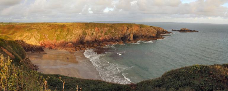
Caerfai Bay with Craig Caerfai on the far right (Photo by Nanuls)


Weather Conditions and Tides
Weather ForecastThis section displays the weather forecast for Caerfai Bay, which as the name suggests, is located right next to Craig Caerfai. Thus, you aren't going to get a much closer weather forecast than this. This weather forecast is generated by the Met Office Weather Widget Tide TimesTide times can have a significant impact on where and when one climbs. It is therefore extremely important to check the timetables before embarking on trip to the area. UK tides information for all standard and secondary ports is provided by the UK Hydrographic Office (UKHO), and displayed on the BBC's website. The link below provides a link to the nearest monitoring station to Craig Caerfai: |

When to Climb and Essential Gear
The most reliable conditions are in the summer, but the low altitude of the crag may make it a viable option in winter. The gear needed depends entirely on the routes you plan to do. Easier routes will only require a moderate rack, while harder routes will require a something more comprehensive; a good compliment of friends or other camming devices will certainly help. A single 50 metre rope should serve well on most easy routes, however, double ropes would be a wise choice for the harder stuff. In addition to your usual gear, you might want to bring along an abseil rope to speed up access to the base of the crag. |


Getting There
Although there are a variety of ways to get to Craig Caerfai, which is located just the south of St. David’s, most will probably be coming from the west. If so, when approaching from Carmarthen (SN 405 196) take the A40 Truck Road signposted for Saint Clears (SN 274 160). At the Saint Clears roundabout, continue along the A40 towards Haverfordwest (SM 962 158). Here you will need to leave the A40, take a short detour through the town, and take the smaller A487 which will signpost St. David’s (SM 753 253). As you enter the city there will be a left hand turn with a signpost directing you to a car park, park and ride and visitors centre (SM 757 252). Take this turn and follow the road to its terminus, here you will find a small parking area overlooking Caerfai Bay (SM 759 243). You will be able to see Craig Caerfai from this vantage point, it’s the crag at the end of the promontory on the eastern side of the bay. From the parking area, take the coastal path eastwards and follow it around the top of Caerfai Bay and out towards the promontory. Here the path gets very close to the top of the Main Slab, which is marked by a number of metal stakes used as anchors (SM 761 240). Abseil from these stakes or down climb White Corner (Diff). |
Camping and Accommodation
Conveniently, there are two great campsites at Caerfai Bay, either of which would make the perfect place to stay if climbing in the area: Caerfai Organic Farm Caerfai Bay Caravan and Tent Park For the wider area, there’s an almost unlimited supply of accommodation within the Pembrokeshire Coast National Park so it would be inappropriate to list it all here. The city of St. David’s and its hinterland is particularly well provided for. For budget accommodation it’s worth checking out some of the following sites: Youth Hostel Association in Wales Independent Hostel Guide Campsites in Pembrokeshire For everything else and more see Visit Pembrokeshire’s website. |
Red Tape and Access
No red tape or access issues here! For climbers, hill walkers and mountaineers, the British Mountaineering Council (BMC) runs a Regional Access Database, which holds mountain/crag specific information on matters of conservation and access, including issues such as nesting restrictions, nature designations and preferred parking: If you are in any doubt about any particular access arrangement, or need to report an incident, you should contact your local BMC Access Representative or the BMC Access Officers for Wales: Elfyn Jones. |

The view towards Ramsey Island (Photo by Nanuls)
Maps
|
| Navigation Maps Ordnance Survey 1:25k Explorer Series OL 35 North Pembrokeshire/Gogledd Sir Benfro Ordnance Survey 1:50k Landranger Series 157 St David’s & Haverfordwest/Tyddewi a Hwlffordd Road Maps |
Guidebooks
|

External Links
 Caerfai Bay (Photo by Nanuls) Caerfai Bay (Photo by Nanuls) Penpleidiau (Photo by Nanuls) Penpleidiau (Photo by Nanuls)Government Bodies and Other Organisations Pembrokeshire Coast National Park Authority Association of National Park Authorities Royal Commission on Ancient & Historical Monuments in Wales Maritime and Coastguard Agency Outdoor Organisations and Companies British Mountaineering Council Pembrokeshire Outdoor Charter Group Weather and Tides Tourist Information Travel Information Welsh Public Transport Information Accommodation Youth Hostel Association in Wales Maps and Guidebooks
Cordee Travel and Adventure Sports Bookshop Wildlife and Conservation Joint Nature Conservation Committee Royal Society for the Protection of Birds |