
|
|
Mountain/Rock |
|---|---|
|
|
51.60534°N / 4.96585°W |
|
|
Pembrokeshire |
|
|
Trad Climbing |
|
|
Spring, Summer, Fall, Winter |
|
|
148 ft / 45 m |
|
|
Overview
The area between Mewsford Point and The Castle is admittedly home to fewer lithological icons than the remainder of the Castlemartin Coast, a fact that is perhaps responsible for placing it on the periphery of most visiting climbers consciences. This absence of attention is however completely unwarranted as there are many, many, fine crags and cragletts to be found here. One such crag, or rather collection of crags, is the small, inset headland of Crickmail Point. |
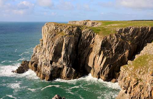
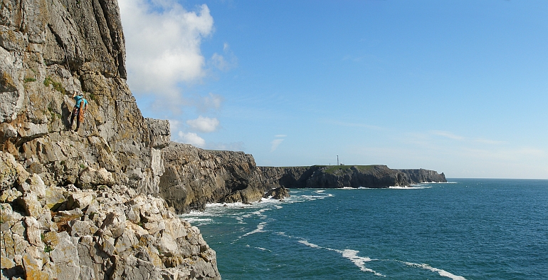
The Point, sometimes known as B-Team Buttress, is home to a collection of surprisingly good routes, all of which take place on good solid rock and although there are no three star classics here, there's certainly enough to keep most discerning climbers happy for a few days. The most popular section of the headland, and justifiably so, is the Upper Tier of the South Face. Here, just a short abseil away, you will find such delights as B-Team Buttress (E1 5b) and Aeron (VS 5a), which lead the climber up a short, compact and beautifully exposed wall, and should be on any visiting climber's hit list. The rest of the climbing is split between The West Face, The Lower Tier of the South Face and the East Face, which although are marginally more difficult to reach, are also home to some interesting and worthwhile adventures. |
Rock Climbing
The climbing at Crickmail Point can be split between four distinct areas – The West Face, The South Face Lower Tier, The South Face Upper Tier and the East Face. In addition to these two Girdle Traverses have also been recorded on the headland. Most of the climbing at Crickmail Point takes place on its upper tiers and is not affected by the tide, however, the lower tier is and the degree to which it is affected is very much dependant on the time of year and the weather. |


Crags and routes are listed from left to right, and are graded and rated with the aid of the old Climbers' Club Guide to Pembroke, the old Pembroke Supplement and the 2009 Rockfax Pembroke guide. Since then, the Climbers' Club have published a new comprehensive guide for this area, Pembroke Volume 3: Range East – Stack Rocks to Hollow Caves Bay, which adds a significant number of new crags and routes to the area, though the changes to this pages' crags are few. Nevertheless it is recommended that you refer to this or the Rockfax book for up-to-date information and route descriptions. In addition to these sources Rockfax’s website also has descriptions for the routes included in its book, which can be viewed on its online route Database. Routes are rated using the British Adjectival Grading System. A conversion table of international climbing grades by SP member Corax is available: download it here. With the exception of Tenby South Beach Quarry, bolting is strictly prohibited everywhere in Pembroke, so don’t even think about it here. Route Symbols:
|

 The West Face The West Face(Photo by Nanuls) | West FaceAs the name suggests this area is located on the western side of Crickmail Point. The section is somewhat underdeveloped and is marred by a lack of sea-level ledges except at its right-hand end where a platform is exposed at all but the highest of tides. The first two routes located on the wall of some 30 metres height to the left of Good Companions. The routes can be reached either by traversing in from Battleship Buttress at low tide, or more practically, by abseiling from anchors in twin cracks down the grass slope just west of the main part of the face. |  The West Face The West Face(Photo by Nanuls) |
| No. | Name | Length | Pitches | Adjectival Grade | Technical Grade | Quality | Restrictions |
|---|---|---|---|---|---|---|---|
| 1. | Raspberry Ripple | 30m | 2 | E2 | 5a, 5b |  | |
| 2. | Marina | 30m | 1 | E3 | 5c | | |
| 3. | Good Companions | 52m | 2 | E4 | 5c, 5a | | |
| 4. | Opening Night | 52m | 2 | E2 | 5b, 5c | | |
| No. | Name | Length | Pitches | Adjectival Grade | Technical Grade | Quality | Restrictions |
|---|---|---|---|---|---|---|---|
| 5. | Trapeze | 46m | 2 | E2 | 5b/5c, 5a | | |
| 6. | Cloud Nine, Hang Ten | 46m | 2 | E2 | 5b, 5b/c |  | |
| 7. | Cloud Nine, Hang Ten Variation | 46m | 2 | E1 | 5b, 5b/c | | |
| 8. | Bounty | 21m | 1 | HVS | 5a | | |
| 9. | Soft Centre | 21m | 1 | HS | 4b | | |
| 10. | Yorkie | 18m | 1 | VS | 4b | | |
| 11. | C.D.M | 15m | 1 | HS | 4b | | |
| 12. | Milky Way | 18m | 1 | S | 4b | | |
| 13. | Galaxy | 18m | 1 | VS | 4c | | |
| 14. | D-Day Landings | 46m | 2 | HVS | 5b, 4c | | |
| 15. | N.A.T.O. Forces | 46m | 2 | E1 | 4b, 5b | | |
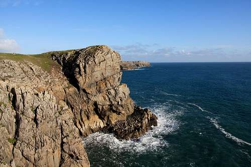
The South Face Upper Tier (Photo by Nanuls)
| No. | Name | Length | Pitches | Adjectival Grade | Technical Grade | Quality | Restrictions |
|---|---|---|---|---|---|---|---|
| 16. | Snap, Popple and Crack | 25m | 1 | VS | 4c | | |
| 17. | Crunchy | 25m | 1 | VS | 4b | | |
| 18. | Krispie Crack | 23m | 1 | VS | 4c | | |
| 19. | Three Shredded Wheat | 23m | 1 | E3 | 5c | | |
| 20. | Catch | 25m | 1 | VS | 4b | | |
| 21. | Read Between the Lines | 25m | 1 | E1 | 5b | | |
| 22. | B-Team Buttress | 25m | 1 | E1 | 5b |  | |
| 23. | Aero | 25m | 1 | VS | 5a | | |
| 24. | Beggar Man | 30m | 1 | E2 | 5c | | |
| 25. | Tinker, Tailor | 25m | 1 | HVS | 5a | | |
| 26. | The Bouncer | 27m | 1 | HVS | 5a | | |
| 27. | Marathon | 26m | 1 | HVS | 5a | | |
| 28. | The Jogger | 25m | 1 | HVS | 5a | | |
| 29. | The Swinger | 25m | 1 | E2 | 5c | | |
| 30. | Slipway | 25m | 1 | S | 4a | | |
| 31. | Warsaw Pact | 24m | 1 | S | 4b | | |
| 32. | Fingerpicking | 22m | 1 | VS | 4c | | |
| 33. | Cheese Please | 24m | 1 | E1 | 5c | | |

Routes on Crickmail Point (For a clean version click here)
| No. | Name | Length | Pitches | Adjectival Grade | Technical Grade | Quality | Restrictions |
|---|---|---|---|---|---|---|---|
| 34. | Turtle's Progress | 43m | 2 | E1 | 5a/5b | | |
| 35. | A Present From the Valley* | 43m | 2 | VS | 4b, 4c | | |
| 36. | Special Communiques | 24m | 1 | E3 | 5c | | |
| 37. | Malice Aforethought | 30m | 1 | HVS | 5a | | |
| 38. | Malice Afterthought | 33m | 1 | HVS | 5a | | |
| 39. | A Town Like Malice | 33m | 1 | E3 | 5c | | |
| 40. | Satisfaction | 37m | 1 | E7 | 6b | | |
| 41. | Eastern Gully | 37m | 1 | VS | 5a | | |
| 42. | Friction Addiction | 37m | 1 | E5 | 6b | | |
| 43. | Emotional Rescue | 40m | 1 | E3 | 5c | | |
| 44. | Sidewinder | 40m | 1 | VS | 4c | | |
*According to the Pembroke Supplement this route is considered to be undergraded by at least two grades. Girdle TraversesA couple of girdle traverses have been recorded on the crag. The first traverses the West Face from left to right and ends on the ledge that splits the South Face's tiers, while the second is a longer high level left to right traverse across both the West and South Faces. |
| No. | Name | Length | Pitches | Adjectival Grade | Technical Grade | Quality | Restrictions |
|---|---|---|---|---|---|---|---|
| 45. | Secret Stratosphere | 37m | 1 | HVS | 5a | | |
| 46. | Footloose and Fancy Free | 67m | 3 | HVS | 5a, 4b, 4c | | |
Weather Conditions and Tides
Weather ForecastThis section displays the weather forecast for Bosherston, which is located just to the east of Crickmail Point. This gives a pretty good indication of what the weather will be like on the crag, as both Bosherston and Crickmail Point sit at around sea level. This weather forecast is generated by the Met Office Weather Widget Tide TimesTide times can have a significant impact on where and when one climbs. It is therefore extremely important to check the timetables before embarking on trip to the area. UK tides information for all standard and secondary ports is provided by the UK Hydrographic Office (UKHO), and displayed on the BBC's website. The link below provides a link to the nearest monitoring station to Crlickmail Point: |

When to Climb and Essential Gear
The most reliable conditions are in the summer, but the low altitude of the crag may make it a viable option in winter. The gear needed depends entirely on the routes you plan to do. Easier routes will only require a moderate rack, while harder routes will require a something more comprehensive; a good compliment of friends or other camming devices will certainly help. A single 50 metre rope should serve well on most easy routes, however, double ropes would be a wise choice for the harder stuff. In addition to your usual gear, you might want to bring along an abseil rope to speed up access to the base of the crag. |


Getting There
Crickmail Point lies around midway between Mewsford Point and The Castle in the Range East portion of the Castlemartin Range. When approaching from Carmarthen (SN 405 196) take the A40 Truck Road signposted for Saint Clears (SN 274 160). At the Saint Clears roundabout, take the A477 Trunk Road towards Pembroke Dock (SM 969 036). Before reaching Pembroke Dock, turn left onto the A4075 (SN 019 027) to Pembroke (SM 989 012). In Pembroke, drive straight over the first small roundabout you reach and drive along the A4139 a few hundred metres and turn left and take the B4319 south towards Castlemartin (SR 915 983). Around 2.5km after Saint Petrox (SR 971 975), take a left hand turn (SR 965 964) signposting Bosherston (SR 965 947). Drive through Bosherston (or stop for a cup of tea at Mrs Weston's Olde Worlde Café) to the Saint Govan's Car Park (SR 966 930). From the car park, walk south to a small guard house and turn right (west), cross the stile at the guard house, and walk along a gravel road passing Stennis Ford and Huntsman's Leap and the Devil’s Barn. Follow the track and cross a fence at a cattle grid. Soon the buildings and masts near The Castle will come into view (SR 955 933), keep these to your left and carry on towards a second fence. Cross the cattle grid at the second fence and continue along the track to a junction, where another track from the right joins the track you’re on. Crickmail Point (SR 947 938) is now directly to your left (which is more or less due south. To reach the abseil point, leave the track and walk onto the now obvious but small headland. |
Camping and Accommodation
There’s an almost unlimited supply of accommodation within the Pembrokeshire Coast National Park so it would be inappropriate to list it all here. The city of St. David’s and its hinterland is particularly well provided for. For budget accommodation it’s worth checking out some of the following sites: Youth Hostel Association in Wales Independent Hostel Guide Campsites in Pembrokeshire For everything else and more see Visit Pembrokeshire’s website. |
Red Tape and Access
| Crickmail Point is located in the Range East portion of the Castlemartin Range. This area is an Army firing range, although they do not use exploding ammunition. Access is permitted whenever firing is not taking place, which is normally on weekends, Bank Holidays, and in the evenings (after 4.30). The night firing normally occurs on alternate Mon/Wed and Tues/Thurs nights. The Range is sometimes open during the week, but it is best to check before travelling. Phone the 24 hour help line on (01646) 662367. For further information, the British Mountaineering Council (BMC) runs a Regional Access Database, which holds mountain/crag specific information on matters of conservation and access, including issues such as nesting restrictions, nature designations and preferred parking: If you are in any doubt about any particular access arrangement, or need to report an incident, you should contact your local BMC Access Representative or the BMC Access Officers for Wales: Elfyn Jones |  A warning sign (Photo by Nanuls) A warning sign (Photo by Nanuls) |
Maps
|
| Navigation Maps Ordnance Survey 1:25k Explorer Series OL 36 South Pembrokeshire/De Sir Benfro Ordnance Survey 1:50k Landranger Series 158 Tenby & Pembroke / Dinbych-y-pysgod & Penfro Road Maps |
Guidebooks
|


External Links
 The South Face Upper Tier (Photo by Nanuls) The South Face Upper Tier (Photo by Nanuls)Government Bodies and Other Organisations Pembrokeshire Coast National Park Authority Association of National Park Authorities Royal Commission on Ancient & Historical Monuments in Wales Maritime and Coastguard Agency Outdoor Organisations and Companies British Mountaineering Council Pembrokeshire Outdoor Charter Group Weather and Tides Tourist Information Travel Information Welsh Public Transport Information Accommodation Youth Hostel Association in Wales Maps and Guidebooks
Cordee Travel and Adventure Sports Bookshop Wildlife and Conservation Joint Nature Conservation Committee Royal Society for the Protection of Birds |