
|
|
Area/Range |
|---|---|
|
|
51.80267°N / 4.96582°W |
|
|
Hiking, Trad Climbing, Sport Climbing, Toprope, Bouldering, Scrambling |
|
|
Spring, Summer, Fall, Winter |
|
|
1759 ft / 536 m |
|
|
Overview
Geraldus was of course biased in his exaltuous descriptions of his native Pembroke, or Penfro in Welsh, and although not quite a native myself, but having spent much of my childhood exploring its countryside, there’s a chance that my little guide might suffer a similar disposition. In our defence though, I think that anyone who has visited this remarkable area will agree that both Geraldus and I are quite justified in our enthusiasm. |
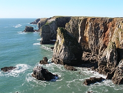
Pembroke is a land of contrasts, both culturally and environmentally. Perhaps the most obvious juxtaposition is that between the land and the sea, and where the two meet, the landforms this has sculpted. The beauty of area’s coastline defies superlatives and is the reason de etra for Pembroke’s wide renown. This scenery is as diverse as it is spectacular, displaying precipitous cliffs, delicate sea stacks, mighty zawns, cavernous sink holes, spectacular rock arches, windswept islands and golden beaches, all packed into the modest confines of Wales’ south-western headland. The coast’s cliffs and outcrops expose the area’s underlying geology, which is just as varied as the landforms it yields, abruptly altering between limestone, sandstone, grit and igneous lithologies, all within a stone’s throw of one another (pun most definitely intended). The geology also gives rise to the distinctly different landscapes displayed by the southern and northern parts of the area. The south is characterised by flat, fertile, largely arable land, which is bound by immensely steep carboniferous limestone and old red sandstone cliffs; while the north is a mixture of igneous rocks and grits which create a much wilder, hillier landscape, which overshadows the surrounding lowlands.  Maelstorm Chimney (S), Stennis Head
(Photo by Nigel Lewis)
Maelstorm Chimney (S), Stennis Head
(Photo by Nigel Lewis)The area’s natural contrasts may also be in part responsible for the cultural and linguistic divide which runs through the region. This divide dates back to the Norman and subsequent English occupation of the area, which although remained fairly stable in the south, was less successful in the north; and while Norman, English and Flemish settlers were happy to take to the fertile plains of the south, they where less willing to toil on the acidic slopes of the north. This combined with the effect of numerous Welsh incursions from Ceredigion, and the difficulty of governing such a wild landscape, meant that the area maintained more of its native identity. The split remains today, with an imaginary boundary known as the Landsker Line running from Marloes Bay in the west, and following a meandering course to Laugharne in the east. In the north therefore, the predominant language is Welsh, which is evident in everything from local culture and customs to architecture and place names; while in the south, a more English culture predominates, gaining the area the epithet of Little England beyond Wales. The importance of the area’s landscape, geology and communities was officially recognised in 1952 with the establishment of the Pembrokeshire Coast National Park, which is the only national park in the United Kingdom to have been designated primarily because of its coastline. Stretching in a 240km ribbon around the Pembroke coast, the Park covers an area of 629km² (243 square miles) and includes many nature sites and areas which are of national and international importance in their own right, including 7 Special Areas of Conservation, a Marine Nature Reserve, 6 National Nature Reserves and 75 Sites of Special Scientific Interest. At its narrowest point, Wiseman's Bridge, it's only 200m wide and even in the Preselis it is no more than 16km in breadth. |
 Sea Mist (HS 4a), Saddle Head
(Photo by Nigel Lewis) | 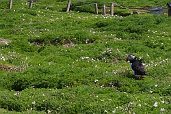 A puffin on Skomer Island
Island (Photo by Nanuls) |
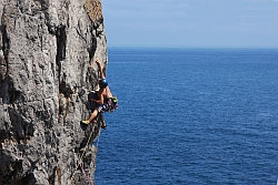
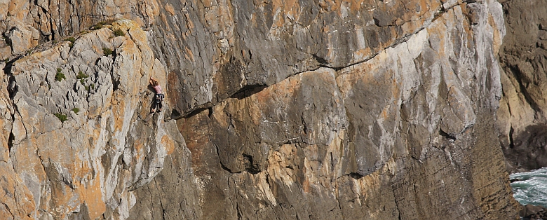
The area takes its name from the town of Pembroke, which was an important settlement during the Middle Ages, and is still home to an impressive castle founded in 1093 by the Norman Lord Roger of Montgomery. Pembroke is derived from the town’s Welsh name Penfro, which means headland, signifying the areas protuberance from the rest of Wales. At first glance, this page may seem out place on a website largely devoted mountains and mountaineering, and it may well be, if it weren't for the fact that the area is home to an almost infinite number high quality traditional rock climbs; most of which take place against the backdrop of the area's spectacular coastline. Furthermore, the aforementioned diversity of the area’s geology ensures that the experience of climbing here is always a unique and varied one. For the most part, the climbing is extremely technical in nature, and some of the hardest routes in Britain can be found here. Owing to the intrinsic nature of coastal climbing, routes also entail a high level of commitment, with most starts requiring an abseil to reach. Self rescue is rarely an option here. |


The area has more to offer than just rock climbing. The famous Pembrokeshire Coast Path is a long distance trail which provides almost continuous and uninterrupted access to the area's coastline. The trail is over 186 miles in length and starts (or finishes depending on your perspective) on the slipway north of St Dogmaels near Cardigan, and ends at the bridge east of Amroth Castle near Tenby. The path is extremely popular with hikers and visits some of finest landscapes Pembrokeshire has to offer. Particular highlights include over 70 quality bathing beaches, innumerable secret coves and zawns, over 40 Iron Age promontory forts, numerous Norman/Medieval castles/ towns (notably Tenby, Manorbier & Pembroke), a chain of Napoleonic forts, scores of lime kilns and other industrial archaeological remains and artefacts, and a series of picturesque fishing ports (notably Solva and Porthgain). As you would expect, countless other outdoor activities are practised in the area too, including surfing, sea kayaking, sailing, and scuba diving. However, as Summitpost isn’t really concerned with these sports, they shall receive only limited attention here. At some point an explanation of the extent of the area covered by this page is going to be needed, so it might as well be sooner rather than later. It would be easy to limit its scope simply to the Pembrokeshire County Boundary, or even easier to that of the National Park, however, to a large extent these are both man made creations, and fail to adequately encompass all that the area has to offer. Therefore, this page's remit has been extended to cover those homogeneous regions that bound Pembroke's borders, namely southern Ceredigion to the north and western Carmarthenshire to the east. |
Horrorscope (E2 5c), Triple Overhang Buttress (Photo by Nanuls)
Coastal Climbing
|
 Highland Fling
(VS 4b),
Stennis Head
(Photo by Nanuls)
Highland Fling
(VS 4b),
Stennis Head
(Photo by Nanuls) | The principle climbing areas are split between the north and the south, and despite Pembroke’s relatively small size, differ considerably in character. They are described here starting in the north-eastern crags of Strumble Head, and work their around the coast in an anti-clockwise direction to finish in the south-east at the historic town of Tenby. Exploration first began in the 1960s and was largely led by Colin Mortlock, whose activity was mostly confined to the northern cliffs. His climbs tended to be on the easier end of the grading spectrum, but many are of extremely high quality, and take place among some truly spectacular surroundings. Over the succeeding years, exploration expanded to the south and Mortlock was joined by such characters as Jim Perrin and Pat Littlejohn, and the difficulty and quality of the routes climbed was increased further. The eighties saw the arrival of a new breed of pioneers such as Nipper Harrison, Martin Crocker, Garry Gibson, Dave Cook and Paul Donnithorne, many of who still put up new lines to this day. |  Sea Mist
(HS 4a),
Saddle Head
(Photo by Nigel Lewis)
Sea Mist
(HS 4a),
Saddle Head
(Photo by Nigel Lewis) |
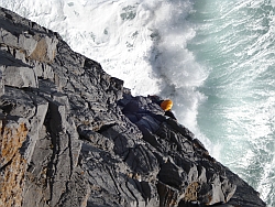
The importance of Pembroke to British climbing cannot be understated. Some of the best trad climbs in the country can be found here, and despite the area's reputation, these routes come in all shapes and sizes – from the hugely entertaining slab of Flimston Crack (VD) to the demanding voyage of Nothing to Fear (E8 6b). There really is something for everyone here. Because most of Pembroke’s crags require an abseil to access, the nature of the climbing is invariably quite serious – once you’ve committed to a crag, you must ascend it. It’s advisable therefore, that in addition to your normal climbing ropes, that a static rope, which can be left in-situ while you climb, be bought along too, and alongside this prusik loops and/or ascenders, which can be used to escape should the need arise. Where secure anchors are scarce, metal stakes have been provided, although many of the older ones are now in poor condition and may require backing up. An additional threat comes in the form of the tide, which is particularly prevalent on the west coast of Britain. Many of the crag-foot stances are tidal in nature, a few of them dangerously so, therefore before climbing a tide time table should always be consulted. These are often available in local climbing and surfing shops, or can be obtained online before embarking on your travels - see the Tides section for more details. Abseils are often a necessity (but sometimes they’re just for fun!): |


And you may have to rely on one of these fellas (be sure to check their stability before committing): |


One final note on needs to be raised concerning fixed gear and ethics. In the past many of the more challenging routes in Pembroke were climbed with the aid of pegs on their first ascent. Most of these pegs should now be regarded as highly suspect and no new pegs should be placed to the area's cliffs, including stainless steel pegs. Routes that still have pegs are slowly being repeated without using them as key runners, an ongoing process with much still to be done. Threads are common throughout Pembroke and tend to be more acceptable to climbers because they rely on the rock's natural features. Climbers should be wary when using them, and if they decide to replace a worn out thread, they should remove the existing one before doing so. One good thread is after all much better than a collection of old tattered ones of variable length. Stuck wires and other forms of gear are also common among Pembroke’s crags, and should be removed if possible. Lastly, with the exception of Tenby South Beach Quarry, bolts have no place in Pembroke, a fact now firmly accepted by the entire climbing community.  Fixed gear = badness
(Photo by Nanuls)
Fixed gear = badness
(Photo by Nanuls)There are currently a number of excellent climbing guidebooks available for the area. The Climbers’ Club have superbly and comprehensively described the area in five lavishly illustrated volumes: Pembroke Volume 1: Pembroke North Pembroke Volume 2: Range West Pembroke Volume 3: Range East - Stack Rocks to Hollow Caves Bay Pembroke Volume 4: Range East - Saddle Head to St Govan’s Pembroke Volume 5: Stackpole and Lydstep These books represent a monumental amount of work and effort and are essential for anyone who intends on doing a lot of climbing in the area. Another good option, which is especially useful for those who either infrequently visit the area or just want to visit the best known bits, is the: It is of course much less comprehensive than the Climbers’ Club offerings, but is nevertheless an excellent quality guide, especially for those on a budget. Either way, if you do plan to climb in Pembroke, be sure to consult one of these books first. Finally, there are also number of mini-guides available in various forms, check out the Guidebooks section for more information. Climbing AreasThis page describes Pembroke’s climbing areas in little bite size chunks, which are in turn, split between the north and south of the area. Check the map below to see where these areas are, and hover your mouse cursor over the highlighted squares to get a bit of info on them. For more detailed information on areas and crags, just scroll down the page. |