
|
|
Mountain/Rock |
|---|---|
|
|
51.60980°N / 4.97539°W |
|
|
Pembrokeshire |
|
|
Trad Climbing |
|
|
Spring, Summer, Fall, Winter |
|
|
131 ft / 40 m |
|
|
Overview
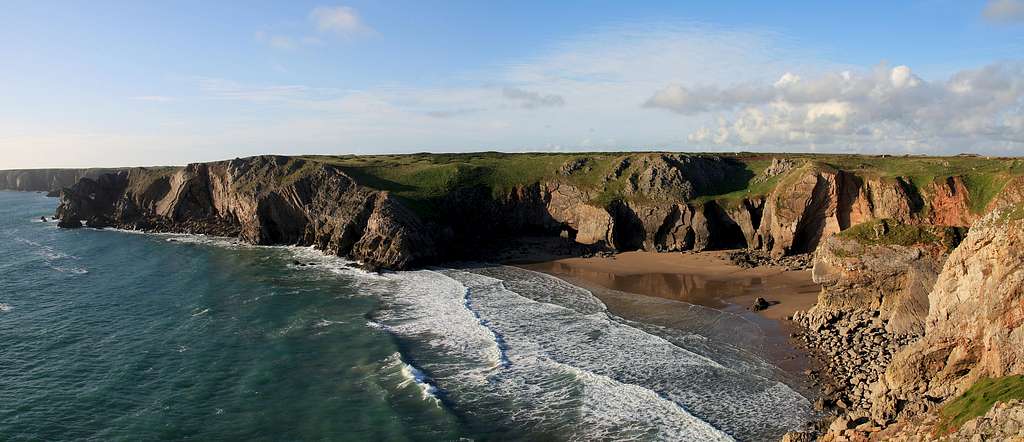
This intriguingly named bay is located towards the centre of Range East and takes the form of one of the few sandy beaches in the Castlemartin Range. Its crags offer a break from the otherwise serious cliffs that surround it, with most of the climbing hovering around the low to mid grades. Although the crags are short, the routes are pleasant, secluded and take place amongst some of the best scenery this stretch of coast has to offer. It should be noted however, that many of the climbs have long, grassy and unprotected run outs, which in places can be quite dangerous. Extra care should therefore be taken whenever topping out, and in some cases, retreat may be a sensible option. |
Rock Climbing
The climbing at Bullslaugter Bay begins on a prominent and obvious square flying buttress with a straight crack (which gives The Zip - Hard Very Severe 5a) in the centre of its seaward face. All climbs begin at sea level and are all in some way affected by the tide, the degree of which can depend of the time of year and weather. Access can be gained by scrambling down a grassy gully and easy rocks on the west side of the bay, walking down a larger gully on the east side, or by abseil. Crags and routes are listed from left to right, and are graded and rated with the aid of the old Climbers' Club Guide to Pembroke, the old Pembroke Supplement and the 2009 Rockfax Pembroke guide. Since then, the Climbers' Club have published a new comprehensive guide for this area, Pembroke Volume 3: Range East – Stack Rocks to Hollow Caves Bay, which adds a significant number of new crags and routes to the area, though the changes to this pages' crags are few. Nevertheless it is recommended that you refer to this or the Rockfax book for up-to-date information and route descriptions. In addition to these sources Rockfax’s website also has descriptions for the routes included in its book, which can be viewed on its online route Database. Routes are rated using the British Adjectival Grading System. A conversion table of international climbing grades by SP member Corax is available: download it here. With the exception of Tenby South Beach Quarry, bolting is strictly prohibited everywhere in Pembroke, so don’t even think about it here. |

Bullslaughter Bay (Photo by Nanuls)
Route Symbols:
|

| No. | Name | Length | Pitches | Adjectival Grade | Technical Grade | Quality | Restrictions |
|---|---|---|---|---|---|---|---|
| 1. | Rydw I'n Byw yn Stockport | 18m | 1 | HVS | 4c |  | |
| 2. | Surf Victim | 37m | 1 | E3 | 5b | | |
| 3. | Culmination | 23m | 1 | E2 | 5b | | |
| 4. | The Zip | 18m | 1 | HVS | 5a | | |
| 5. | Thriller | 20m | 1 | HVS | 5a | | |
| 6. | Zawn off Shotgun | 20m | 1 | HVS | 5a | | |
| 7. | E Six, Six B | 23m | 1 | VS | 4c |  | |
| 8. | Cheeseboard | 24m | 1 | HVS | 4c | | |
| 9. | Zap | 21m | 1 | VS | 4b | | |
| 10. | Whacko Jacko | 24m | 1 | HVS | 4c |  | |
| 11. | Beat it | 21m | 1 | VS | 4c | | |
| 12. | Griller | 24m | 1 | HVS | 4c | | |
| 13. | Beat Up | 21m | 1 | HS | 4b | | |
The following routes start on the right hand side of the large cave on a slab with a shallow corner up its centre. Topping out is dangerous! |
| No. | Name | Length | Pitches | Adjectival Grade | Technical Grade | Quality | Restrictions |
|---|---|---|---|---|---|---|---|
| 14. | Secondary Route | 24m | 1 | S | 4a | | |
| 15. | Ordinary Route | 24m | 1 | VD | | |


On the east side of the little bay containing the slab is a 'Mousetrap-type' wall with a steep slab on its left. The following routes start on a rib just below the slab: |
| No. | Name | Length | Pitches | Adjectival Grade | Technical Grade | Quality | Restrictions |
|---|---|---|---|---|---|---|---|
| 16. | Patent Pending | 30m | 1 | S | 4a | | |
| 17. | Copyright | 30m | 1 | VS | 4c | | |
| 18. | Squeeze It | 27m | 1 | VS | 4c | | |
| 19. | Little Mousetrap | 37m | 1 | HVS | 5b | | |
| 20. | Brave Face | 30m | 1 | E3 | 5b | | |
In the centre on the bay is a lone pinnacle, this route ascends its south face: |
| No. | Name | Length | Pitches | Adjectival Grade | Technical Grade | Quality | Restrictions |
|---|---|---|---|---|---|---|---|
| 21. | The Canine Tooth | 15m | 1 | D | | |

Mewsford Point (Photo by Nanuls)
The following routes are on the east face of a long, grass-topped promontory on the east side of the bay. Approach via a through cave on the promontory at mid to low tide. A long tunnel runs under the promontory out towards the sea; the routes begin on the seaward mouth of the tunnel. |
| No. | Name | Length | Pitches | Adjectival Grade | Technical Grade | Quality | Restrictions |
|---|---|---|---|---|---|---|---|
| 22. | The Extortionist | 46m | 1 | HVS | 5a | | |
| 23. | Pavement | 40m | 1 | E1 | 5a | | |
| 24. | Jaywalk | 30m | 1 | E2 | 5b | | |
| 25. | Colonol Portman and His Amazing Briefs | 15m | 1 | VS | 4c | | |
Weather Conditions and Tides
Weather ForecastThis section displays the weather forecast for Bosherston, which is located just to the east of Bullslaughter Bay. This gives a pretty good indication of what the weather will be like on the crag, as both Bosherston and Bullslaughter Bay sit at around sea level. This weather forecast is generated by the Met Office Weather Widget Tide TimesTide times can have a significant impact on where and when one climbs. It is therefore extremely important to check the timetables before embarking on trip to the area. UK tides information for all standard and secondary ports is provided by the UK Hydrographic Office (UKHO), and displayed on the BBC's website. The link below provides a link to the nearest monitoring station to Bullslaughter Bay: |

When to Climb and Essential Gear
The most reliable conditions are in the summer, but the low altitude of the crag may make it a viable option in winter. The gear needed depends entirely on the routes you plan to do. Easier routes will only require a moderate rack, while harder routes will require a something more comprehensive; a good compliment of friends or other camming devices will certainly help. A single 50 metre rope should serve well on most easy routes, however, double ropes would be a wise choice for the harder stuff. In addition to your usual gear, you might want to bring along an abseil rope to speed up access to the base of the crag. |


Getting There
When approaching from Carmarthen (SN 405 196) take the A40 Truck Road signposted for Saint Clears (SN 274 160). At the Saint Clears roundabout, take the A477 Trunk Road towards Pembroke Dock (SM 969 036). Before reaching Pembroke Dock, turn left onto the A4075 (SN 019 027) to Pembroke (SM 989 012). In Pembroke, drive straight over the first small roundabout you reach and drive along the A4139 a few hundred metres and turn left and take the B4319 south towards Castlemartin (SR 915 983). Around 500m after the Merrion Camp (SR 939 968), take a left hand turn at a crossroads (SR 931 970) and drive down an unclassified road to the Stack Rocks Car Park (SR 925 946). Park at the Stack Rocks Car Park and walk west along the coastal path, past Elegug Stacks, The Cauldron, and Flimstone Bay to your final destination, Bullslaughter Bay (SR 940 942). |
Camping and Accommodation
There’s an almost unlimited supply of accommodation within the Pembrokeshire Coast National Park so it would be inappropriate to list it all here. For budget accommodation it’s worth checking out some of the following sites: Youth Hostel Association in Wales Independent Hostel Guide Campsites in Pembrokeshire For everything else and more see Visit Pembrokeshire’s website. |
Red Tape and Access
| Bullslaughter Bay is located in the Range East portion of the Castlemartin Range. This area is an Army firing range, although they do not use exploding ammunition. Access is permitted whenever firing is not taking place, which is normally on weekends, Bank Holidays, and in the evenings (after 4.30). The night firing normally occurs on alternate Mon/Wed and Tues/Thurs nights. The Range is sometimes open during the week, but it is best to check before travelling. Phone the 24 hour help line on (01646) 662367. For further information, the British Mountaineering Council (BMC) runs a Regional Access Database, which holds mountain/crag specific information on matters of conservation and access, including issues such as nesting restrictions, nature designations and preferred parking: If you are in any doubt about any particular access arrangement, or need to report an incident, you should contact your local BMC Access Representative or the BMC Access Officers for Wales: Elfyn Jones |  A warning sign (Photo by Nanuls) A warning sign (Photo by Nanuls) |
Maps
|
| Navigation Maps Ordnance Survey 1:25k Explorer Series OL 36 South Pembrokeshire/De Sir Benfro Ordnance Survey 1:50k Landranger Series 158 Tenby & Pembroke / Dinbych-y-pysgod & Penfro Road Maps |
Guidebooks
|


External Links
 On the Ordinary Route - V. Diff On the Ordinary Route - V. Diff The "mouse-trap" type type slab (Photo by Nanuls) The "mouse-trap" type type slab (Photo by Nanuls)Government Bodies and Other Organisations Pembrokeshire Coast National Park Authority Association of National Park Authorities Royal Commission on Ancient & Historical Monuments in Wales Maritime and Coastguard Agency Outdoor Organisations and Companies British Mountaineering Council Pembrokeshire Outdoor Charter Group Weather and Tides Tourist Information Travel Information Welsh Public Transport Information Accommodation Youth Hostel Association in Wales Maps and Guidebooks
Cordee Travel and Adventure Sports Bookshop Wildlife and Conservation Joint Nature Conservation Committee Royal Society for the Protection of Birds |