
|
|
Mountain/Rock |
|---|---|
|
|
51.59760°N / 4.94228°W |
|
|
Pembrokeshire |
|
|
Trad Climbing |
|
|
Spring, Summer, Fall, Winter |
|
|
131 ft / 40 m |
|
|
Overview
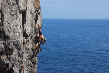
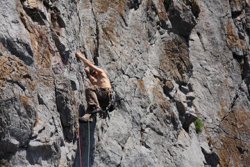
Of all the headlands in Pembroke, perhaps even in Britain, there are few that can match Stennis Head for its formidable array of outstanding climbs. This magnificent bastion of rock is one of the many gems in Pembroke’s jewel encrusted crown - the Castlemartin Range - and easily holds its own against its neighbours, those other two Pembroke paragons of climbing, Huntsman’s Leap and Stennis Ford. It boasts a combination of excellent single and multi-pitch routes, which populate every tier of its rock faces, and are almost without exception, accessible at all states of the tide. Easy access to its western flank is facilitated by a gradual rock ramp, while much of the eastern side can be reached either by abseil or, if the tide is right, a tricky downward scramble. The majority of the routes are in the mid to high grades, most of which are easily accessible and rise steeply from the non tidal platform on the headland’s western side. Here you will find such classics as Hercules (HVS 5a), Manzoku (E1 5b), and Cool for Cats (E1 5b), while around the corner, the Pleasure Dome Area ramps up the difficulty, giving the superb Pleasure Dome (E3 5c), Stennis the Menace (E6 6b) and Grey English Morning (E5 6a). Hidden below the western access ramp is another of Stennis’ not to be missed routes, the superbly positioned and extremely photogenic rising traverse of Riders on the Storm (HVS 5a). If you’re an able climber, this really is somewhere you must visit, and if the quality of the routes alone isn’t enough to persuade you to climb here, then perhaps the aspect will. Despite being a headland, the crags of Stennis Head are nicely sheltered by the surrounding coastline, and its western platform in particular forms an attractive sun trap making it an extremely comfortable venue, even in the depths of a cold Welsh winter. |
Rock Climbing
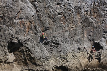
The climbing at Stennis Head can be split between two main areas: the South West Face, which is split between an Upper and a Lower Tier, and the South Buttress. Only the Lower Tier of the South West Face is affected by the tide, and even then this only affects a few of the routes. |

Crags and routes are listed from left to right, and are graded and rated with the aid of the old Climbers' Club Guide to Pembroke, the old Pembroke Supplement and the 2009 Rockfax Pembroke guide. Since then, the Climbers' Club have published a new comprehensive guide for this area, Pembroke Volume 4: Range East – Saddle Head to St. Govans, which adds a significant number of new crags and routes to the area, though the changes to this pages' crags are few. Nevertheless it is recommended that you refer to this or the Rockfax book for up-to-date information and route descriptions. In addition to these sources Rockfax’s website also has descriptions for the routes included in its book, which can be viewed on its online route Database. Routes are rated using the British Adjectival Grading System. A conversion table of international climbing grades by SP member Corax is available: download it here. With the exception of Tenby South Beach Quarry, bolting is strictly prohibited everywhere in Pembroke, so don’t even think about it here. |
 Maelstorm Chimney - S 4a Maelstorm Chimney - S 4a(Photo by Nigel Lewis) |  Newton Head Newton Head(Photo by Nanuls) |  The South-Western Face The South-Western Face(Photo by Nanuls) |
|
Route Symbols:
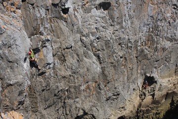
South West FaceApproximately 100 metres west of the centre of the headland is an easy gully that leads down to the start of the prominent non-tidal slabs which gives access to the routes on the Upper Tier. The slab ends beneath the right-hand side of the face at a narrow chimney which drops into the sea. Immediately to the right of this feature the cliff forms a white overhanging wall which gives Pleasure Dome, which overlooks the small inlet between the South-West Face and the South Buttress. Lower Tier/Riders on the Strom AreaThe first thirteen routes are on the Lower Tier, which can be viewed by scrambling down to the west from the top of the easy gully. The first five routes (Bloody Knee to Cut-Throat) are approached by abseil down the left hand side of the face. Don't do it at mid tide! The next eight routes (Riders on the Storm to The Anvil Chorus) start on the right-hand side of the wall and are approached by scrambling down an easy rib directly beneath the descent gully. |
| No. | Name | Length | Pitches | Adjectival Grade | Technical Grade | Quality | Restrictions |
|---|---|---|---|---|---|---|---|
| 1. | Bloody Knee | 23m | 1 | VS | 5a |  | |
| 2. | Sinister Sister | 24m | 1 | E2 | 5b | | |
| 3. | Pugwash | 24m | 1 | HVS | 5a |  | |
| 4. | Mind the Dawes | 30m | 1 | E1 | 5b | | |
| 5. | Cut-Throat | 43m | 1 | E2 | 5c | | |
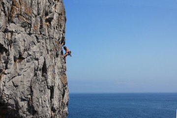
| 6. | Riders on the Storm | 30m | 1 | HVS | 5a |  | |
| 7. | C++ | 24m | 1 | HVS | 5a | | |
| 8. | Lucky Find | 43m | 2 | HVS | 5a, 4c | | |
| 9. | Big C | 40m | 1 | E1 | 5a | | |
| 10. | Reincarnation | 30m | 1 | E2 | 5b | | |
| 11. | Middle C | 43m | 1 | HVS/E1 | 5a | | |
| 12. | Painted Head | 34m | 2 | VS | 4b, 4c | | |
| 13. | The Anvil Chorus | ? | 1 | HVS | 5b | | |

| No. | Name | Length | Pitches | Adjectival Grade | Technical Grade | Quality | Restrictions |
|---|---|---|---|---|---|---|---|
| 14. | The Digit Counter Falls | 15m | 1 | VS | | | |
| 15. | North Corner | 15m | 1 | VD | | | |
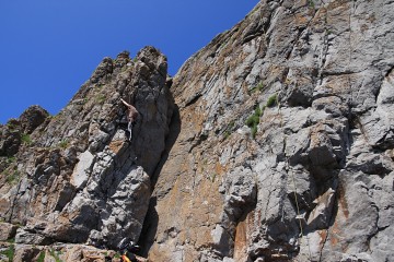
| 16. | Highland Fling | 18m | 1 | VS | 4b | | |
| 17. | Quickstep | 18m | 1 | VS | 4b | | |
| 18. | Limbo | 23m | 1 | VS | 4c | | |
| 19. | Dire Straits | 18m | 1 | E3 | 5c | | |
| 20. | World War III Blues | 20m | 1 | E1 | 5b | | |
| 21. | Headucation | 27m | 1 | E3 | 5c | | |
| 22. | Plank Walk | 30m | 1 | E5 | 6b | | |
| 23. | Hercules | 34m | 1 | HVS | 5a | | |
| 24. | Flash | 34m | 1 | E4 | 6a |  | |
| 25. | The Second Coming of the Messiah | 34m | 1 | E5 | 6b | | |
| 26. | Stennis Elbow | 37m | 1 | E2 | 5c | | |
| 27. | Manzoku | 37m | 1 | E1 | 5b | | |
| 28. | Man Alive | ? | 1 | E2 | 5b | | |
| 29. | Cool for Cats | 37m | 1 | E1 | 5b | | |
Pleasure Dome Area |

Topo of climbs on the Pleasure Dome Area. For a clean version of the photo click (Photo by Nanuls)
| No. | Name | Length | Pitches | Adjectival Grade | Technical Grade | Quality | Restrictions |
|---|---|---|---|---|---|---|---|
| 30. | Sten Gun | 37m | 1 | E3 | 6a | | |
| 31. | Anyone for Stennis | 38m | 1 | E2 | 5b | | |
| 32. | Loco Dementia | 18m | 1 | E3 | 6a | | |
| 33. | Tigger's Traverse | ? | 2 | HVS | 4c, 4c | | |
| 34. | Stennis Pillar | 40m | 2 | HVS | 4c, 4a | | |
| 35. | Gold Fever | 34m | 1 | E2 | 5c | | |
| 36. | Diagnosis | 34m | 1 | E4 | 6a | | |
| 37. | Mean Streak | 34m | 1 | E5 | 6a | | |
| 38. | The Great Elmyra | 30m | 1 | E5 | 6c | | |
| 39. | Pleasure Dome | 46m | 1 | E3 | 5c | | |
| 40. | Stennis the Menace | 40m | 1 | E6 | 6b | | |
| 41. | Grey English Morning | 30m | 1 | E5 | 6a | | |
| 42. | Grey English Morning Direct | 46m | 1 | E5 | 6a | | |
| 43. | Walk on the Wild Side | 24m | 1 | E3 | 5c | | |
| 44. | Superbrat | 70m | 4 | E2 | 5b, 5c, 5a, 5b | | |
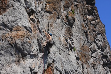
 Maelstorm Chimney Maelstorm Chimney– S 4a (Photo by Nigel Lewis) |  The Southern Buttress The Southern Buttress(Photo by Nanuls) |  Manzoku Manzoku- E1 5b (Photo by Nanuls) |  Stennis Ford Stennis Ford- to the east (Photo by Nanuls) |
| No. | Name | Length | Pitches | Adjectival Grade | Technical Grade | Quality | Restrictions |
|---|---|---|---|---|---|---|---|
| 45. | Stennis Chimney | 73m | 2 | S | | | |
| 46. | Maelstrom Chimney | 61m | 2 | S | 4a | | |
| 47. | Stennis Arête | 70m | 2 | HS | 4b, 4b | | |
| 48. | Fetish | 38m | 1 | E4 | 6a | | |
| 49. | Merchant of Stennis | 30m | 1 | E3 | 5c | | |
| 50. | Man o' War | 30m | 1 | E3 | 5c | | |
| 51. | Bludgeon | 34m | 1 | HVS | 5a | | |
| 52. | Mistaken Identity | ? | 1 | E1 | 5b | | |
| 53. | Big Wave | 30m | 1 | E2 | 5c | | |
| 54. | White Snake | 37m | 1 | HVS | 5a/5b | | |
| 55. | The Lamb Lies Down on Broadway | 34m | 1 | HVS | 5b | | |
| 56. | J.K. Mouth of the South | 24m | 1 | E1 | 5a | | |
Weather Conditions and Tides
Weather ForecastThis section displays the weather forecast for Bosherston, which is located just to the east of Stennis Head. This gives a pretty good indication of what the weather will be like on the crag, as both Bosherston and Stennis Head sit at around sea level. This weather forecast is generated by the Met Office Weather Widget Tide TimesTide times can have a significant impact on where and when one climbs. It is therefore extremely important to check the timetables before embarking on trip to the area. UK tides information for all standard and secondary ports is provided by the UK Hydrographic Office (UKHO), and displayed on the BBC's website. The link below provides a link to the nearest monitoring station to Stennis Head: |

When to Climb and Essential Gear
The most reliable conditions are in the summer, but the low altitude of the crag may make it a viable option in winter. The gear needed depends entirely on the routes you plan to do. Easier routes will only require a moderate rack, while harder routes will require a something more comprehensive; a good compliment of friends or other camming devices will certainly help. A single 50 metre rope should serve well on most easy routes, however, double ropes would be a wise choice for the harder stuff. In addition to your usual gear, you might want to bring along an abseil rope to speed up access to the base of the crag. |
Getting There
When approaching from Carmarthen (SN 405 196) take the A40 Truck Road signposted for Saint Clears (SN 274 160). At the Saint Clears roundabout, take the A477 Trunk Road towards Pembroke Dock (SM 969 036). Before reaching Pembroke Dock, turn left onto the A4075 (SN 019 027) to Pembroke (SM 989 012). In Pembroke, drive straight over the first small roundabout you reach and drive along the A4139 a few hundred metres and turn left and take the B4319 south towards Castlemartin (SR 915 983). Around 2.5km after Saint Petrox (SR 971 975), take a left hand turn (SR 965 964) signposting Bosherston (SR 965 947). Drive through Bosherston (or stop for a cup of tea at Mrs Weston's Olde Worlde Café) to the Saint Govan's Car Park (SR 966 930). From the car park, walk south to a small guard house and turn right (west), cross the stile at the guard house, and walk along a gravel road to Stennis Ford (SR 963 930). If you want to access the eastern side of the crag, follow the right (western) side of zawn to the end of the headland and abseil off a metal stake. If you are heading for the more popular western side of the headland, carry on walking along the path to Huntsman's Leap (SR 961 930) and follow its left (eastern) side to a rocky ramp that descends onto a non-tidal platform at the base of the headland (SR 963 928). |
Camping and Accommodation
There’s an almost unlimited supply of accommodation within the Pembrokeshire Coast National Park so it would be inappropriate to list it all here. For budget accommodation it’s worth checking out some of the following sites: Youth Hostel Association in Wales Independent Hostel Guide Campsites in Pembrokeshire For everything else and more see Visit Pembrokeshire’s website. |
Red Tape and Access
| Stennis Head is located in the Range East portion of the Castlemartin Range. This area is an Army firing range, although they do not use exploding ammunition. Access is permitted whenever firing is not taking place, which is normally on weekends, Bank Holidays, and in the evenings (after 4.30). The night firing normally occurs on alternate Mon/Wed and Tues/Thurs nights. The Range is sometimes open during the week, but it is best to check before travelling. Phone the 24 hour help line on (01646) 662367. For further information, the British Mountaineering Council (BMC) runs a Regional Access Database, which holds mountain/crag specific information on matters of conservation and access, including issues such as nesting restrictions, nature designations and preferred parking: If you are in any doubt about any particular access arrangement, or need to report an incident, you should contact your local BMC Access Representative or the BMC Access Officers for Wales: Elfyn Jones |  A warning sign (Photo by Nanuls) A warning sign (Photo by Nanuls) |
Maps
|
| Navigation Maps Ordnance Survey 1:25k Explorer Series OL 36 South Pembrokeshire/De Sir Benfro Ordnance Survey 1:50k Landranger Series 158 Tenby & Pembroke / Dinbych-y-pysgod & Penfro Road Maps |
Guidebooks
|


External Links
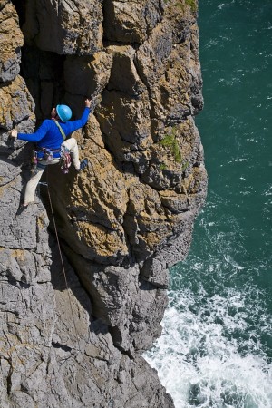 Maelstorm Chimney – S 4a (Photo by Nigel Lewis) 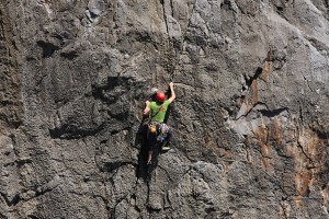 Riders on the Storm – HVS 5a (Photo by Nanuls)  Quickstep – VS 4b (Photo by Nanuls) 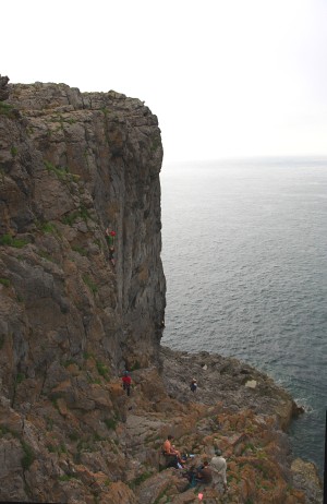 The South-Western Face (Photo by Nanuls) Government Bodies and Other Organisations Pembrokeshire Coast National Park Authority Association of National Park Authorities Royal Commission on Ancient & Historical Monuments in Wales Maritime and Coastguard Agency Outdoor Organisations and Companies British Mountaineering Council Pembrokeshire Outdoor Charter Group Weather and Tides Tourist Information Travel Information Welsh Public Transport Information Accommodation Youth Hostel Association in Wales Maps and Guidebooks
Cordee Travel and Adventure Sports Bookshop Wildlife and Conservation Joint Nature Conservation Committee Royal Society for the Protection of Birds |