this route maybe the best first contact with this mountain
Approach
Starting point is Piano dei Resinelli.
Here you can arrive from Milano - ss 36 (Spluga) till Lecco (at the bottom of the east branch of Como lake) - then follow the indications for Valsassina, reach Ballabio wherefrom the road to Pian dei Resinelli starts.
Entering in Piano dei Resinelli, just before arriving to the the big car parking, follow, on the right, the road till Rifugio Sem.
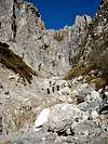
You may go on some hundreds meters, along a white road and get a good parking zone under the slopes situated on the right (west) side of Canalone Porta
The name of the route comes from its first climber : Carlo Porta (a Lombardic poet)
Route Description
From the white road some easy to find paths start toward north.
They all bring you, through a fine wood, to the main path, marked with a double white and red stripe (path n°2) that, toward east, leads to the lower part of Canalone.
Here you can find some signs indicating the directions for Canalone Porta and/or Cresta Sinigaglia. Start walking directly on the stony bottom of the channel, here very wide and not steep.
..
Now, following the stripes go on, climbing here and there some short drops that allow to gain the middle part of the channel.
..
At a certain point the channel looks closed by an high vertical wall, here is the starting point of a real, not difficult but somewhere exposed, rock climb.
....
On the right a short (40m) ridge allowes to get the starting point of a ramp that from right to left, brings you over the wall. (careful with falling stones)
..
Now another not short ramp allows you to get the path coming from (west ) Cermenati ridge.
From the little ridge till this point the difficulties are costantly of 1° UIAA (some short vertical passage could be considered of 2°)
From there 3 different possibilities :
follow the path to the left and get the Cermenati ridge (normal route to Grignetta)
follow along the channel, low tracked, that, passing under the west walls of Sigaro and Torrioni Magnaghi, leads you to the summit ridge near the "Bocchetta dei Venti" wherefrom, on the left, following the ridge (some metal chains and some exposed passages - class 4) you get the summit of Cima di Campione and the following summit of Grignetta.
follow the path to the right, cross the notch (Bocchetta dei Prati) and, just a little before the rescue helycopter platform, follow the path that, along some rocky slabs under the eastern walls of Torrioni Magnaghi, leads you to the summit ridge where from east the Cresta Sinigaglia arrives.
Follow the ridge (path) and with two little exposed passages (metal chains) cross under the N slabs of Torrione Magnaghi Settentrionale and get the Bocchetta dei Venti wherefrom you can follow the ridge till the summit.
Winter - early Spring climb
climbing the Canalone Porta, when full of good snow, is very amusing, a real route of about 800m drop, not so easy but good to practice and training, and, of course, less tiring than when dry.
I think it is the best winter-spring route to the summit of Grignetta.
If you're trained the climb can go on, along the traversata alta till the summit of Grignone.
The most advisable route is the one that goes straight on along the channel till the ridge.
Essential Gear
No special gear in summer
Iceaxe and crampons in winter (a rope could be useful)
Parents refers to a larger category under which an object falls. For example, theAconcagua mountain page has the 'Aconcagua Group' and the 'Seven Summits' asparents and is a parent itself to many routes, photos, and Trip Reports.

 9631 Hits
 77.48% Score
 8 Votes