-
 39636 Hits
-
 96.73% Score
-
 62 Votes
|
|
Area/Range |
|---|---|
|
|
45.95320°N / 9.38720°E |
|
|
Hiking, Trad Climbing, Sport Climbing, Aid Climbing, Via Ferrata, Skiing |
|
|
Spring, Summer, Fall, Winter |
|
|
7906 ft / 2410 m |
|
|
Overview
|
If you are looking for something that looks like Dolomites, if you are near Milan, Como, Bergamo ecc. , like vertical climbing on limestone rock and want to spend one day amusing this is for you.
This is the climbing zone of the famous groups of climbers : "Ragni di Lecco" and "Pell e oss di Monza"
From this mountains some famous climbers : Walter Bonatti, Riccardo Cassin ... and a lot of Lombardic members of the CAAI (Club Alpino Accademico d'Italia : Italy climbers elite) started their alpinistic career, even Comici came here and opened a route on the "Nibbio" whose starting point is a good test :)
Here I met Messner, Gogna, Piussi, Sorgato, Desmaison ... all Italy and some French famous climbers.
I would like to remember here some friends of mine (known here) that can no more climb ...
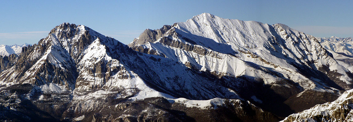
This group can be divided in 3 main sections (from north to south) :
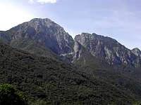
- Grignone (Grigna settentrionale) : the highest summit (2410 m) - in this section many big walls (up to 800m) with fine sweet paths for tourists, fine routes for hikers, strong walls for climbers ... - Grignetta (Grigna meridionale) : the most famous (2177 m) - little paradise for tourist, hikers, climbers with paths, routes, pinnacles ...
- Coltignone (1479 m) - San Martino (1046 m) : the southern section with its famous walls (i.e. the "Medale" and "Antimedale") and rich with modern climbing routes.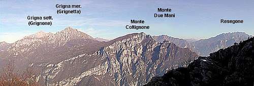
The group boundaries are on the west side the Como lake and on east and north sides the Valsassina.
Till 20 years ago, on Sundays, its walls. edges, pinnacles, tops and routes were always full of people amusing and making experiences.
After the starting of the bouldering this group began to be a little neglected (here one must walk a little to get the starting points of the routes).
Some fine and not always easy paths call hikers and tourists to spend a fine day in a strange wonderful environment.
| warning ! Grignetta (South summit) is sadly known for the accidents causing the death of many tourists and climbers: out of the 2 easy (but somewhere a little exposed) tourist paths (the Cermenati Ridge to the summit and the Foppe path to Rifugio Rosalba) all the others paths and routes require attention and "steady feet". Special attention, for not expert hikers and climbers, must be paid to the very steep grassy slopes that normally end on bad quality rock cliffs |
Getting There
From Milano - ss 36 (Spluga) till Lecco (at the bottom of the east branch of Como lake) - then
- if you want to get Grignetta suibgroup follow the indications for Valsassina, reach Ballabio and then follow the road to Pian dei Resinelli
- for the eastern side of Grignone go along the Valsassina road till Colle di Balisio
- for the northern side of Grignone go along the Valsassina road, till Cortenova
- for the western (more comfortable access) side of Grignone, from Lecco follow the SS36 and exit to Esino Lario then follow the road to Passo del Cainallo
- to reach the most difficult walls of the group (Sasso Cavallo and Sasso dei Carbonari) starting point is Mandello Lario (on the SS 36)
Almost all routes can be done in one day starting from Milan (only some extreme routes on Sasso Cavallo and Sasso dei Carbonari require to spend the night in the Huts)
The most important starting points for hiking and climbing for Grignetta is "Pian dei Resinelli" - (Valsassina-Ballabio).
See the sections for more info
Grigna settentrionale (Grignone)
The main summit of the group - on the top is the Rifugio Brioschi : getting it is an easy hiking
- from Balisio (723 m - Valsassina) passing through Pialeral (Rif. Tedeschi - 1428 m)
- from Esino (826 m) by car till Passo del Cainallo (1270 m) and passing through Poiat (Rif. Bogani - 1816 m) or starting from Rif. Bietti 
Wonderful in winter as ski-mountaneering (especially from Pialeral) with a fine descend in the channel under the summit,
some danger (carsic holes) in the north ski-route (from Rif. Bogani)
Also very fine the "Traversata Alta", from the summit of Grignetta : in winter, with snow and ice, it is a "grand course"
not difficult but complete 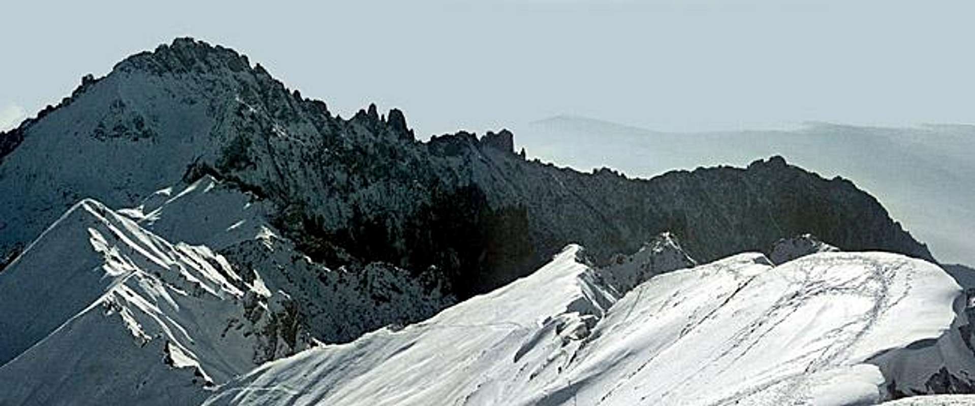
from Bietti (West side) 4 easy routes lead to the summit :
- via del Caminetto - 1.30 hours
- via del Canalone - 2.30 hours
- via del Guzzi - 2.30 hours
- ferrata CAI Mandello - 3 hours
Grigna settentrionale ridges and branches
It has 4 ridges :
West ridge with 2 important summits :![]()
![]()
- Sasso dei Carbonari - 2160 m - on its south wall (500 m drop) 2 very difficult routes
- Sasso Cavallo - 1923 m - on its south wall (400 m drop) 3 very difficult routes (up to ED)
North-East ridge with 2 important summits :![]()
- Pizzo della Pieve - 2257 m
on its north wall (800 m drop) some alpinistic routes (AD to TD)
in winter and with ice can be the best training for high mountain big walls
![]()
- Pizzo d'Eghen - 1832 m
on its north and west walls (up to 500 m)
some interesting routes (Ad to TD)
North-West ridge (cresta di Piancaformia)
is a fine run on a F sup route
nothing short, all requires almost a full day
South ridge, the ridge of the (traversata alta)
is the long ridge that joins the two main summits of the Group : Grignetta (S) and Grignone (N)
on this ridge, starting from the "Buco di Grigna" some minor summits called "scudi" (shields) that are normally crossed during the climb and don't have other climbing importance
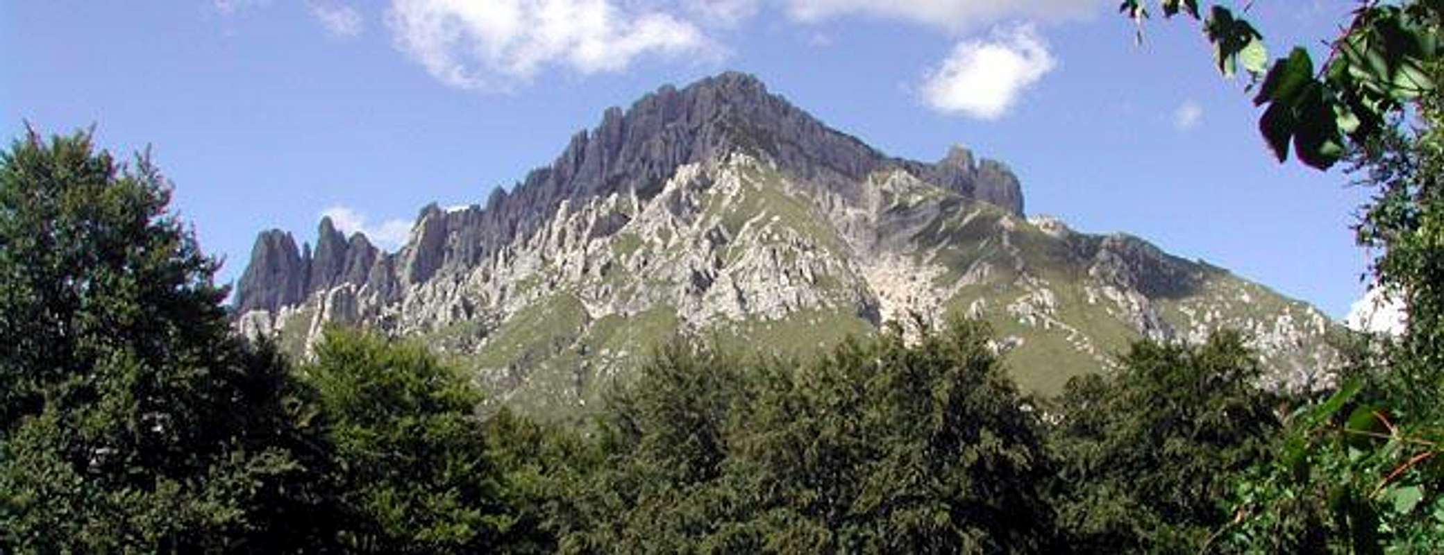
Grigna meridionale (Grignetta)
The most famous subgroup
This is a very complex mountain with 4 main ridges :![]()
- south ridge: cresta Cermenati - normal route - the easiest - for nor experienced (and masochist) hikers
between the south and the west ridges some channels
- canalone Caimi - very easy, good for coming down - especially when full of snow
- canalone del Caminetto - only 1 passage to climb on - F+ - fine in winter with snow
- canalone dei Piccioni - easier than the previous one - fine in winter with snow - west ridge : cresta Segantini - the finest to the summit (PD)
from this ridge some secondary ridges start southward.
They are full of pinnacles (drop from 50 to 250 m) that can be considered as indipendent summits and, of course, have got their own names and elevations
These sub-ridges are divided by some channels all joining to the Sentiero Cecilia
- canalone di val Tesa
- canalone Garibaldi
- canalone Valsecchi fine in winter with snow
that allow approach to the pinnacles and are crossed by the panoramic (not easy) route "la Direttissima"
between the west and the north ridges a valley : val Scarettone with a strange subridge "cresta del Giardino" - north ridge : cresta della traversata Alta - the ridge between Grignetta and Grignone (F sup)
(a forgotten wall/edge gives directly to the summit with not easy climb)
between the north and the east ridges :
- canalino Federazione (starting point to the "traversata alta", about 100 m under the east summit)
- canalone north-east (il Gerone) - east ridge : cresta Sinigaglia - easy but requiring some climbing skill in the higher parts (F sup)
from this ridge starts, southward, the important
- Magnaghi group and ridge that ends with the Torrione Fiorelli
between the east and the south ridges
- canalone Porta - amusing and easy (but not for hikers)- fine in winter with snow
... schematic map and references points
to understand this complex structure
![Grignetta schematic map]()
![this is a map you can see at...]()
![here a pic from south with...]()
![West ridge of Grignetta]()
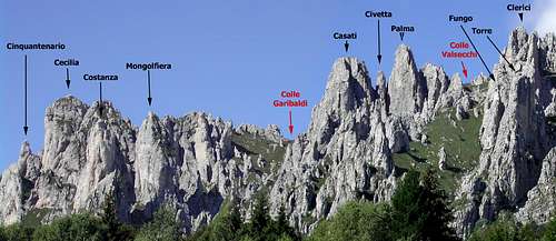
Rosalba-Giulia ridge
This is the group of pinnacles (50 - 150 m drop) with the most difficult routes in Grignetta.
Routes can be reached in half an hour from Rif. Rosalba and, at most in 2 hours from Rif. Porta or Pian dei Resinelli (car parking)
Main "summits" are : - torre Cecilia - easiest route PD - most difficult TD - best route the spigolo (edge) Marimonti
- torrione Cinquantenario - easiest route AD - most difficult ED - best route the Gandini (TD)
- la Mongolfiera - easiest route D - most difficult ED - rock not always fine ..
- torre Costanza - easiest route D - most difficult ED - best route the "via del Littorio" (TD)
- punta Giulia - easiest route D - most difficult TD - short but fine
Best rocky tour here :
- 1 - Torrione Cinquantenario - Gandini route - 120m - TD
- 2 - Torre Cecilia - Marimonti edge - 80m (from the saddle) - D
- 3 - Grigna Meridionale - Segantini ridge - 250m - PD
for the images give a look to this album
val Tesa ridge
This is the group of pinnacles (50 - 160 m drop) with the most frequently climbed routes in Grignetta.
Routes can be reached in one hour from Rif. Rosalba and, at most in 2 hours from Rif. Porta or Pian dei Resinelli (car parking)
Main "summits" are : - Piramide Casati - easiest route F - most difficult TD - best routes the Vallepiana edge and the Gasparotto crack
- torrione Palma - rock not fine
- torrione Clerici - easiest route F - most difficult TD - best route the S edge (spigolo del Clerici) (D)
- ago Teresita - 50 m of amusement - all TD or more - best route the Gandini (TD)
- guglia Angelina - easiest route AD - most difficult TD - best route the E wall (via Mary) TD - rock not always safe
- il Campaniletto - easiest route PD - most difficult TD inf - best route the Molteni (TD inf)
- la Lancia - easiest route AD - most difficult TD - best route the Accademici (D inf)
- la Torre - easiest route AD - most difficult TD - best route the Corti (D)
- il Fungo - easiest route D - most difficult ED - wonderful the S edge (ED or TD/A)
Best rocky tours here :
classic : "il giro del Fungo" - The Fungo tour
- 1 - La Torre - Corti route - 70m (3 pitches) - D
- 2 - Il Fungo - S edge - 120m (5 pitches) - TD
- 3 - La Lancia - Accademici route - 40m (2 pitches) - D inf
- 4 - Il Campaniletto - Molteni route - 40m (2 pitches) - TD inf
- 5 - along the Val Tesa channel up to the Segantini ridge
- 6 - Grigna Meridionale - Segantini ridge - 250m - PD
or (shorter but more difficult) - 1 - Guglia Angelina - Cassin route (via Mary) - 100m (5 pitches) TD
- 2 - Ago Teresita - Gandini dihedral - 50m - (2 pitches) - TD
- 3 - Torrione Clerici - Boga route (S edge) - 120m - (5 pitches) - D
- 4 - Grigna Meridionale - Segantini ridge - 250m - PD
or (shorter and less frequented) - 1 - Piramide Casati - Vallepiana edge - 150m (6 pitches) - D
- 2 - Piramide Casati - Gasparotto crack - 130m (6 pitches) - D
- 3 - Grigna Meridionale - Segantini ridge - 250m - PD
for the images give a look to this album
Magnaghi
This is a massif (the hugest here) that has 3 summits well chained and a wonderful pinnacle : il "Sigaro"
The easiest route is the normal to the south summit (PD)
Worth to be climbed, amusing and not easy : - all the routes to Sigaro (70-90 m drop) difficulties from D to TD
- the classic concatenation : Albertini (to S summit) - cross to central summit and the Lecco (to N summit) - D - very amusing
- the hard climbs on the west wall of South Magnaghi - 150 m drop - difficulties from TD to ED
- the east crack (via Gandini) to the central summit - 130 m - D sup (the best)
- the south (yellow) wall to the central summit - 130 m - difficulties from ED inf to ED sup
for the images give a look to this album
Fiorelli
The Torrione Fiorelli is the most known summit of a small group growing up, well detached, from the lower part of the East ridge of Grigna Meridionale.
Normally low frequented because it is out of the typical concatenations of routes used for training in this range.
This minor subgroup is made by 3 different "summits" - the Torre Gino - very minor, almost never climbed
- the Torrione della Grotta (1714m)
- the Torrione Fiorelli (1673m)
for the images give a look to this album
the Nibbio
Out of the ridges of the Grignetta, out of the main ridge joining the Grignetta to Coltignone, on its eastern side a strange rocky structure grows up directly from woods and meadows with an overhanging wall hosting 47 different routes, both classic and sport.
Once (30-40 years ago) it was considered a second best in bad weather days or in winter, and, in such days climbers used to train along some classic difficult routes (Cassin-Campione-Comici-Boga ...) and one (not difficult) aided route (Mckinley)
Now, it has become again popular with its new modern routes (up to 7c-5.14) and the old aided route, now climbed in free, has become the most difficult one.
here you can find some good and complete info about sport climbing routes
![the Nibbio]()
the Nibbio![the Nibbio - East wall]()
East wall![the Nibbio]()
from N![the Nibbio - Mckinley route]()
the K pitch of Mckinley
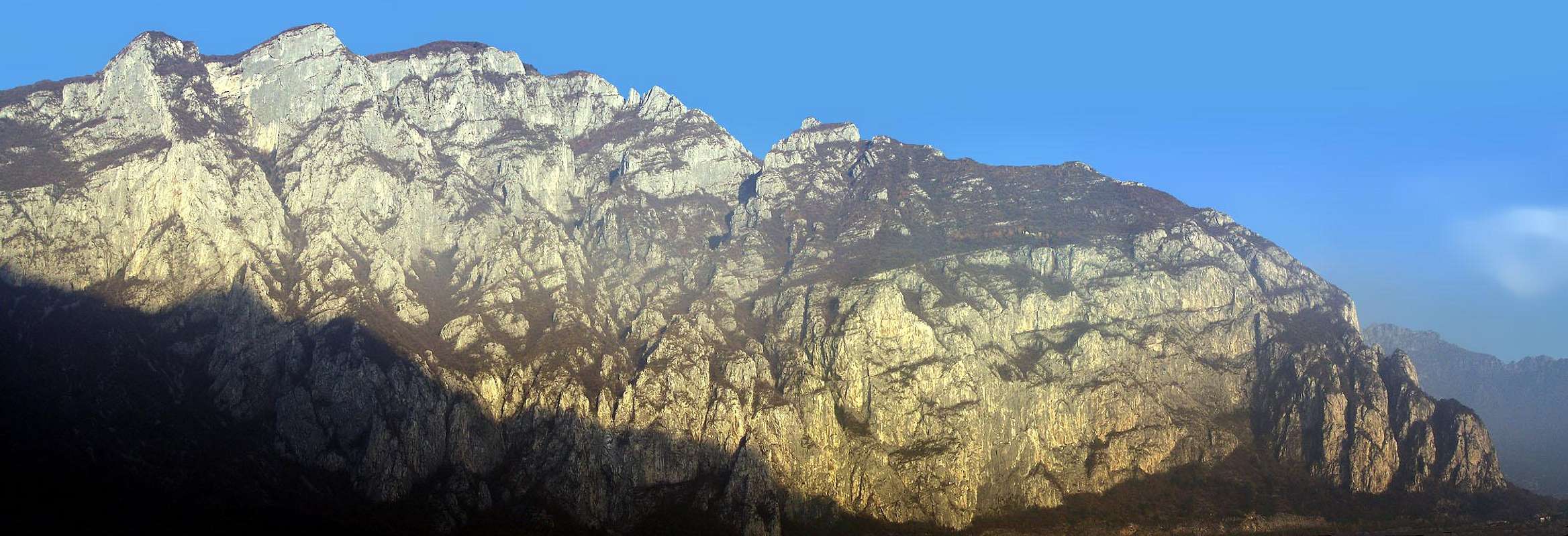
Coltignone-San Martino
The long big ridge descending toward South from the Pian dei Resinelli, so, the "extension" of the Grigne group going down to the lake.
This ridge had 2 very different sides : - in the Eastern one, mostly covered by grass making very steep meadows, some really very interesting, famous and popular structures
This is the section where to find long (400 m drop) climbs and new extreme modern routes :
the parete Medale with a lot (29) of routes :
very amusing![Medale]()
the Medale wall from Laorcathe easier and most classic is the via Cassin (D sup)
this wall is usually climbed in the afternoon when sun goes away from it
![]()
![]()
![Medale wall from Lecco]()
the Medale wall from Lecco - the via Taveggia (TD) (best route), the via Boga (TD), the Gogna (ED) and the Bonatti pillar (ED inf)
the Antimedale with 9 routes (200 m drop) with difficulties starting from TD (via Chiappa and via degli Istruttori) to modern ED - even the difficult ones are amusing !
between Medale and Antimedale a hard "ferrata" brings to the starting point of the Bonatti pillar, can be run only by expert hikers !!! - the western one, straight upon the Lecco branch of the lake is made by an almost unique rocky wall arriving down to the road, broken in few points by steep (dangerous) grassy channels that give access to the many sectors of the wall where, after the '80s, a lot of classic and sport routes have been opened. I think that some pillars and walls here are still waiting for new routes.
![]()
![The ridge of Coltignone]()
![Vetta San Vittore]()
![I Pizzetti]()
When To Climb
all year long ...
in Grignetta, in summer, carry a good supply of water : the only available water is the one coming down from the sky ...
![]()
![]()
![]()
![]()
![]()
Winter shots
Winter hiking, climbing and skiing can be very fine here ... but even the normal route of Grignetta (cresta Cermenati) can be very dangerous with unsafe snow - 1 friend of mine died there (and was a very skilled one : Angelo Pizzocolo - CAAI)
![]()
![]()
![]()
![]()
![]()
![]()
Books
A recent guidebook on the climbing areas around the Grigne is Arrampicate Sportive e Moderne fra Lecco e Como by Pietro Corti, published by Edizioni Versante Sud.
Two older books, which appear to be out of print, are:
* Arrampicate in Grignetta, by Dante Porta and Bruno Morandini, Edizioni il Gabbiano, 1985.
* Arrampicate scelte nel Lecchese, by Valerio Casari and Lele Dinoia, Melograno Edizioni, 1985.
All three books are in Italian, and none appears to have an ISBN.
thanks to Brenta
climbing difficulties
The Difficulties of the Routes above are in French or in UIAA degrees
Note 2 - the Difficulties of the Routes you can find in some books are sometimes "strange", normally underestimated, I remember that they used to say that the crack to get the saddle between la Torre and la Lancia was 2° (it is a good 4° !!)
Meteo forecast
tempoitalia
Meteo Rifugio Brioschi - Servizio gratuito offerto da Meteo Webcam
this is both a Group and a Mountain page
The 3 main summits : Grigna settentrionale, Grigna Meridionale and Monte Coltignone, and related rocky structures are normally considered in climbing environments, a single mountain ... but, just to better manage it I think I'm going to create 3 different more detailed pages.