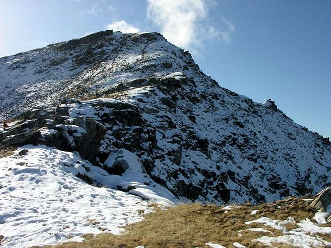
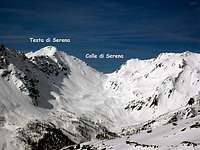
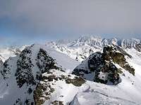
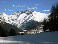
Testa Serena is a pyramid of scree and rock located on the watershed ridge, to the southeast of Colle di Serena (2.547m). It is an excellent point to enjoy vistas of the little-known surrounding valleys: Comba di Planaval to the west, the high hanging Valley of Bosses to the north, and Comba di Vertosan to the southeast.
First Ascents
Unknown.
Getting There
BY CAR:
From Torino, Milano, etc: Motorway A5. Exit at Aosta Ovest.
From Switzerland: through the Grand Saint Bernard Tunnel or the namesake pass. From France,through the Mont Blanc Tunnel or Petit Saint Bernard Pass: It is not necessary to take Motorway A5: you can drive on SS.26, in the direction of Aosta.
BY PLANE:
Aeroporto "Corrado Gex" Saint Christophe (Aosta).
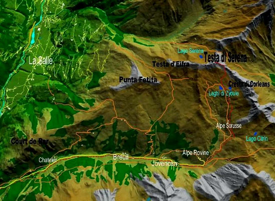
From the Aosta ovest (Aymavilles) exit of the motorway, take SS.26 toward Courmayeur. After about 5 km, you'll reach the Village of Saint Pierre (731m). Turn right on the road for the small Village of Saint Nicolas (1.200m). Past the village, you'll reach a fork. The right branch leads to Vetan (1.671m). Take instead the left branch and after approximately 1 km turn right in the direction of Colle di Joux (1.898m). The road for the col, clearly marked by road signs, reaches in five kilometers (full of twists and turns) a small reservoir surrounded by a wooden fence in the proximity of Col di Joux (1.898m). Only authorized vehicles can continue past this point. Therefore, park here in the lot and hike along the farm road that enters the beautiful hanging Valley of Vertosan. The road is slightly downhill at first, then climbs gently. During the summer, when the restaurant in Jovencan is open, it is possible to get there by car. If you come from the north, you may prefer, right after the Village of Runaz, to turn on the road that, with narrow switchbacks, reaches Avise first, and then Cerellaz. Continue a little past the tiny Village of Charbonnière, and then turn left on the road for Col di Joux described in the itinerary that goes through Saint Nicolas. Info given by Gabriele:
Another usual approach to this mountain, normally used in winter for the ski mountaneering route, starts from the Motorway of Gran San Bernardo (Italian side). Just before the toll gate you must follow (on the left side, coming from Aosta) the marks to Bosses and go along till you get Mottes - this is normally the starting point of an easy and safe ascent that, along gentle slopes, leads to the Col Serena, wherefrom you can get the summit without big efforts.
Route
After about 1 hour you pass Alpe di Jovencan (1.867m). Leave on your left Alpe di Rovine (2.082m) and climb along the trail on the right of the hanging valley till Alpeggio di Sorusse (2.205m) (3h'00 from the parking lot). Continue along the trail (marked by cairns, which are not always easy to spot) until you reach the plateau where the Zyoule Lakes (2.524m and 2.542m) are located. Climb to Colle di Corléans (2.700m), from where you can enjoy a wonderful panorama of the Mont Blanc Massif and a close-up view of the imposing Grande Rochère (3.326m). From the col climb the last 130m of the North ridge, paying attention in case of snow or verglass (5h'00/5h'30 from the trailhead). Elevation gain: about 950m. Time for the ascent: 5h'00/5h'30 hours.
Difficulties
The route is classified E/F.
Equipment
Normal hiking gear.
Campings
Remember that free camping is forbidden (except for emergency reasons, over 2.500m, from darkness until dawn).
Mountain Condition
Meteo: you can find all the needed informations at the official site of the Valle d'Aosta Region:
"Guida dei Monti d'Italia-Alpi Pennine" (Vol. I°) di Gino Buscaini-Club Alpino Italiano/Turing Club Italiano, Luglio 1971 (in Italian).
"80 itinerari di Escursionismo Alpinismo e Sci Alpinismo in Valle d'Aosta", di Osvaldo Cardellina, Ed. Musumeci, Giugno 1977 (in Italian); seconda Ed. Luglio 1981; terza Ed. Luglio 1984; (in French), prima Ed. Febbraio 1978; seconda Ed. Marzo 1980.
MAPS
Kompass "Monte Bianco Valle d'Aosta Sentieri e Rifugi" Carta turistica 1:50.000.
I.G.C. Istituto Geografico Centrale "Carta dei sentieri e dei rifugi" 1:25.000.
I want to thank Fabio (Brenta) for the translation of the text from Italian and also Livioz who provided the coordinates of the summit and helped with the edit.
Parents refers to a larger category under which an object falls. For example, theAconcagua mountain page has the 'Aconcagua Group' and the 'Seven Summits' asparents and is a parent itself to many routes, photos, and Trip Reports.

 9267 Hits
 93.81% Score
 44 Votes