

-
 10151 Hits
-
 86.84% Score
-
 25 Votes
|
|
Mountain/Rock |
|---|---|
|
|
45.76661°N / 7.16325°E |
|
|
Mountaineering |
|
|
Spring |
|
|
9656 ft / 2943 m |
|
|
Overview
Monte Rosso di Vertosan (not to be confused with the nearby Mont Vertosan) is an amazing ski-mountaineering hike in the heart of Mont Fallère Group. Situated North side of Punta Leysser, or more know as Leissé and not visible from Vetan tourist Hamlet, Monte Rosso offers great slopes for funny thrill descent expecially in springtime, when snow is perfectly assested. This ski-hike required perfectly safe snow, expecially attacking the unnamed pass at the begin of Southern Ridge (double carving at an altitude of about 2.715 meters which could be called Passo di Paletta (z) Nord distinguishing it from the Southern Paletta's Pass of 2.707 meters). A good ascent technique with skis is necessary to get to the base of the ridge. The slope is very steep and ski-crampons are useful, expecially with icy snow. In addition to the Normal Via, described and recommended here, it is quite frequented the crossing route starting from Punta Aouilletta or Oilletta (2.616m) and bypassing Punta Leissé (2.771m) and Punta di Paletta (z) or Quota 2.810 meters; in this case, pay attention, especially in case of snow, in the descent from the latter to the unnamed notch or double carving, since the rock is fragile and exposed, even if only for a short distance. Another itinerary runs along the Northeast Crest starting from the Colle di Vertosan Sud (2.768m); a slender and easy track for chamois hunters follows it in the the base, while the integral path on the edge of the ridge presents some fun, albeit short, climbing passages (from I° to II°+). Once arrived on summit, great sightseen on all Aosta mountains, expecially on Mont Blanc Group. Avoid the both (Monte Rosso di Vertosan and Mont Fallère) after fresh snow, and in winter time: danger of avalanches or snowslides to deal with too high.
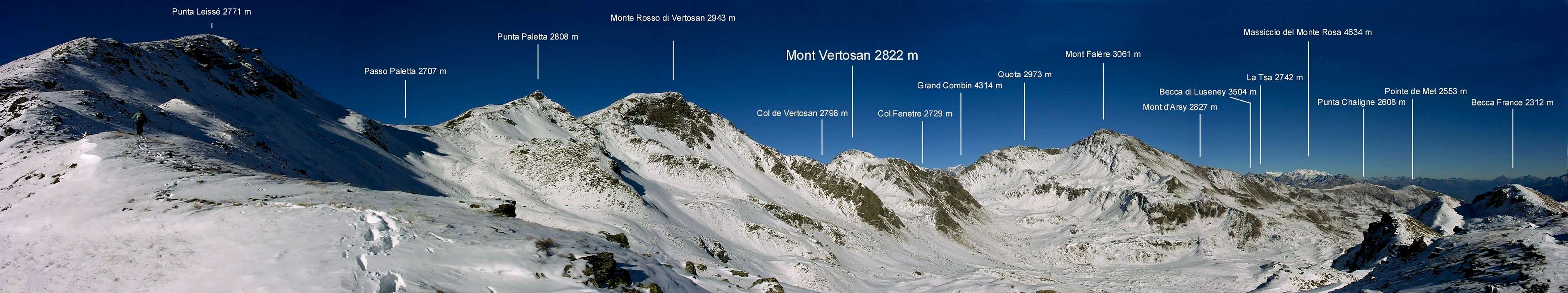
Il Monte Rosso di Vertosan (da non confondere con il vicinio Mont Vertosan) risulta come una splendida nonché remunerativa escursione scialpinistica nel cuore del Gruppo del Monte Fallère. Situato sul lato Nord di Punta Leysser o più conosciuta come Punta Leissé, e non visibile dal Villaggio turistico di Vetan, il Monte Rosso offre itinerari sci alpinistici per divertenti discese da brivido soprattutto in primavera, quando la neve é perfettamente assestata. Questa escursione sugli sci richiede neve perfettamente sicura, in particolare attaccando il passo senza nome all'inizio della Cresta Sud (doppio intaglio a quota 2.715 metri circa che potebbe essere chiamato Passo di Paletta(z) Nord distinguendolo dal Meridionale 2.707 metri). Per raggiungere la base della cresta risulta necessaria una buona tecnica di risalita con gli sci. La pendenza é molto ripida e sono utili i ramponi da sci, soprattutto con la neve ghiacciata. Oltre alla Via Normale, qui descritta e consigliata, risulta abbastanza frequentato il percorso con traversata partendo da Sud-ovest ovvero dalla Punta Aouilletta oppure Oilletta (2.616m) e scavalcando la Punta Leissé (2.771m) e la Punta di Paletta(z) o Quota 2.810 metri; in questo caso prestare attenzione, soprattutto in caso di neve, nella discesa da questa ultima al doppio intaglio innominato, poiché la roccia risulta fragile ed esposta, anche se per breve tratto. Un altro itinerario percorre la Cresta Nordest partendo dal Colle di Vertosan Sud (2.768m); una esile e facile traccia per cacciatori di camosci la percorre alla base, mentre il percorso integrale sul filo della cresta presenta alcuni divertenti, seppure brevi, (dal I° al II°+). passaggi in arrampicata. Una volta arrivati in vetta, grandiosa veduta su tutte le montagne di Aosta, in particolare sul Gruppo del Monte Bianco. Evitare sia il Monte Rosso di Vertosan che il Fallere dopo la neve fresca e in inverno: pericolo di valanghe e slavine da affrontare.
First Ascent
- First in the Summit: Unknown.
- First in winter: Unknown.
- East-southeast Slope and Southern Crest (Normal Via): Unknown.
- Southeast Face (Direct route on central rib): Osvaldo Cardellina, lone, November 05th, 1988.
- Northeast Crest: Unknown hunters.
- Northeast Crest: (Integral on the edge of the ridge): Osvaldo Cardellina, lone, November 05th, 1996.
Vetan is a small village in Saint Pierre commune. There are a lot of possibilities to arrive here. The easiest is to drive to Saint Pierre, then turn onto SR.22. Drive for about 9 km to reach the peaceful tiny village of Saint Nicolas. Once crossed the small village, arrived in a hairpin bend, turn right onto SR.41 (la "Strada dei Salassi"). Ahead for about 2,5 kms until Persod village. Turn left for Grand Sarriod/Gerbore/Vetan: 3 km to Vetan. Park the car at the end of main paved road, exactly in front of Hotel Notremaison (parking free). How to get to Saint Pierre.
- From Turin, Milan, Genoa. Follow Aosta direction on Motorway A5. Shortest and fastest way is to exit at Aosta Ovest (West Aosta), out of motorway follow Aosta - Saint Pierre direction, once on SS.26 (main national free road of Aosta Valley), turn left. In a couple of kms, just under Saint Pierre Castle, turn right on SR.22 described above. Please note: for all foreign drivers and for all italians not "Telepass" owner, if you exit at Aosta Ovest, paying cash or credit card, you'll be billed for whole ticket to Courmayeur, and this is very expansive. A true thievery! To partially f**k motorway owner, exit at Aosta E, cross Aosta on road SS.26 Courmayeur direction. Pass Aosta, Sarre, go ahead arrived at Cogne/Motorway A5 fork. After this traffic light, 2 km to arrive at Saint Pierre.
- From France (Petit St. Bernard, Mont Blanc). Drive onto road SS26 direction Aosta. Before arriving in Sarre/Aosta, in Saint Pierre, turn left onto SR.22 road. It is possible to get directly onto SR.41 (Salassi Road) from Avise (via Cerellaz, Saint Nicolas), but the road is very narrow and complicated.
- From Switzerland (Grand Saint Bernard pass/tunnel). I suggest to descend in Aosta, follow Courmayeur direction (road SS.26) until in Saint Pierre. Then turn right to SR22 for Saint Nicolas described above. For skilled drivers, arrived in Gignod it is possible to get directly onto SR.41 (Salassi Road), from Excenez village, without descendin in Aosta. This road is a kind of labyrinth ... good area knowledge is required!
Route
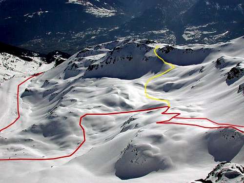
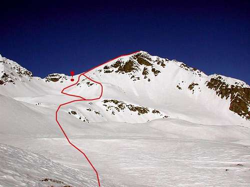
From the tourist Village of Vetan Dessous (1.697m) follow the farm road on the ground which then turns into trail n° 12 reaching the Pastures of Granzettaz (1.780m) and Thoules Alpages (1.944m); from here continue with the path n° 13 reaching the more great Grandes Arpilles Alp (2.133m), where the dirt road is resumed again. Leaving left or West the branch for the Alpeggio di Pesse, continue instead towards East-Northeast reaching the mini collar 2.206 meters and entering the Vallone di Verrogne. Continue decidedly towards the North reaching the Alpe Les Crottes (2.385m), where it is better to make a stop. Just before the same (or near an earlier water outlet) there is a small trail that, crossing the Torrent de Verrogne, goes back to the West through "quiet" grassy slopes and then steeper and detrital. Climb back up into the small valley or up the newly marked Southeastern Crest until you reach an altitude of 2.750 meters; from here bend gradually to the left and reach the double notch or carving of Paletta(z) Nord (see overview). From this it is easy to follow the rounded South Ridge which with debris and rocks easily leads to the Summit (F; 1h'30 from Alpe Les Crottes; 3h'00/3h'15 from Vetan Hamlet).
 |
 |
 |
Dal Villaggio di Vetan Dessous (1.697 m) seguire la strada poderale in terra battuta che poi si trasforma in sentiero n° 12 raggiungendo gli Alpeggi di Granzettaz (1.780 m) e Thoules (1.944 m); da qui proseguire con il sentiero n° 13 raggiungendo la più grande di Grandes Arpilles (2.133 m), dove si riprende nuovamente la strada poderale. Lasciato a sinistra od Ovest il ramo per l'Alpeggio di Pesse, si prosegue invece verso Est-nordest raggiungendo il Colletto 2.206 metri ed inserendosi nel Vallone di Verrogne. Continuare decisamente verso Settentrione raggiungendo l'Alpe Les Crottes (2.385 m), dove conviene effettuare una sosta. Appena prima della medesima (oppure nei pressi di una presa dell'acqua antecedente) parte una piccola traccia di sentiero che, attraversato il Torrent de Verrogne, risale verso Occidente attraverso "tranquilli" pendii erbosi e poi più ripidi, nonché detritici. Risalire nel valloncello oppure risalendo sulla appena marcata Cresta Sudest sino a raggiungere l'altitudine di 2.750 metri; da qui piegare gradualmente a sinistra e raggiungere il doppio intaglio di Paletta(z) Nord (vedi overview). Da questo facilmente percorrere l'arrotondata Cresta Sud che con detriti e roccette facilmente conduce alla Sommità (F; 1h'30 dall'Alpe Les Crottes; 3h'00/3h'15' da Vetan).
Difficulty & Equipment
F, or with F+ snowshoeing; and still with snow and for skiers BSA (Good alpine skiers).
F, oppure con racchette da sci F+; ed ancora con neve e per sciatori BSA (Buoni sciatori alpinisti).
Campings
Remember that free camping is forbidden (except for emergency reasons, over 2.500m, from darkness until dawn).
Mountain Condition
- Meteo: you can find all the needed informations at the official site of the Valle d'Aosta Region:
- Valle d'Aosta Meteo
Webcam
- WEBCAM on Aosta Valley:
- Webcam
Image by Buxlex
 |
 |
 |
 |
 |
 |
 |
 |
 |
 |
 |
 |
 |
 |
 |
Books and Maps
BOOKS:
- "Guida dei Monti d'Italia-Alpi Pennine" (Vol. I°) di Gino Buscaini-Club Alpino Italiano/Turing Club Italiano, Luglio 1971 (in Italian).
- "80 itinerari di Escursionismo Alpinismo e Sci Alpinismo in Valle d'Aosta", di Osvaldo Cardellina, Ed. Musumeci, Giugno 1977 (in Italian); seconda Ed. Luglio 1981; terza Ed. Luglio 1984; (in French), prima Ed. Febbraio 1978; seconda Ed. Marzo 1980.
 |
 |
MAPS:
- Kompass "Monte Bianco Valle d'Aosta Sentieri e Rifugi" Carta turistica 1:50.000.
- Ediz. Bottega D'Arte Alpina Coumayeur "Carta Turistica della Valle d'Aosta" di Alessio Nebbia 1:100.000.
- I.G.M. Istituto Geografico Militare 1:25.000.
Important Information
- REGIONE AUTONOMA VALLE D'AOSTA Ufficial Site
- FONDAZIONE MONTAGNA SICURA Villa Cameron, località Villard de la Palud n° 1 Courmayeur (AO) Tel: 39 0165 897602 - Fax: 39 0165 897647.
- A.I.NE.VA. (Associazione Interregionale Neve e Valanghe).
Useful numbers
- Protezione Civile Valdostana località Aeroporto n° 7/A Saint Christophe (Ao) Tel. 0165-238222.
- Bollettino Valanghe Tel. 0165-776300.
- Bollettino Meteo Tel. 0165-44113.
- Unità Operativa di Soccorso Sanitario Tel. 118.