
|
|
Mountain/Rock |
|---|---|
|
|
45.88632°N / 10.82243°E |
|
|
Trentino |
|
|
Hiking, Scrambling, Via Ferrata |
|
|
Spring, Summer, Fall, Winter |
|
|
4088 ft / 1246 m |
|
|
Overview
Cima S.A.T. 1246 m
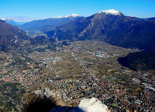
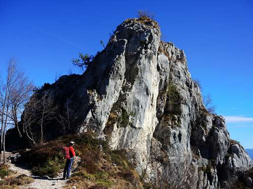
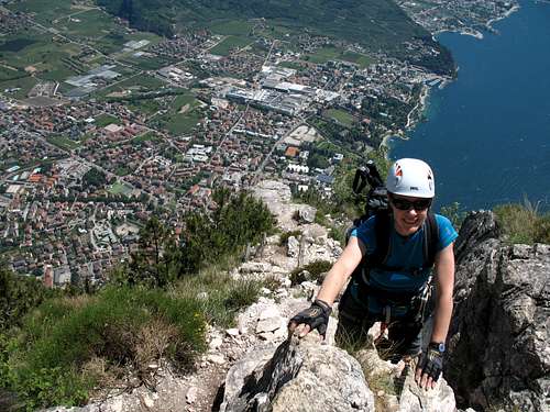
Cima S.A.T. 1246 m is a small rocky spire located above Garda Lake in the group of the Prealpi Bresciane e Gardesane. The spire is a panoramic balcony of exceptional beauty located right in front of Monte Stivo. It is looming over the town of Riva del Garda with vertical rocky walls and steep slopes facing East for more than 1000 meters. Observed instead from the South, it appears as a small rocky spire near the Rocchetta Giochello.
It's a beautiful and popular rocky peak with excellent views above the Garda Lake, Torbole, Riva and Arco, Monte Brione, Corno and Catena di Pichèa, Tenno Lake, Monte Misone, Monte Stivo and Monte Altissimo di Nago. Three reasons make the ascent to Cima SAT a fine experience: the interest of the various routes and the Via Ferrata, the breathtaking views over the near Garda Lake and the surrounding mountains and the remains of the First World War, a powerful defensive system built by the Austro-Hungarians on this mountains lying in a strategic position, with the purpose to check from the top the enemy troops' movements.
There are three ascent routes to Cima SAT, which can be combined in various ways, and all start from Riva del Garda.
Getting There
The starting point to climb Cima S.A.T. is Riva del Garda.
Access: from the Brennero autoroute exit Rovereto Sud and take the road to Riva del Garda.
Route across Capanna Santa Barbara
Cima SAT across Capanna Santa Barbara
Difficulty: EEA
Difference in level: 1180 from Riva del Garda
Route description
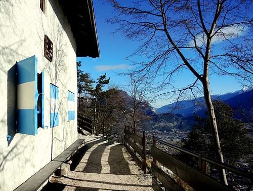
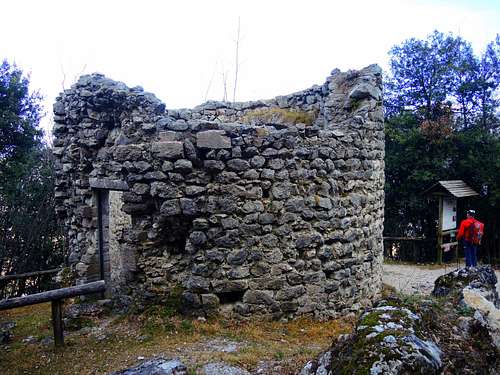
After reaching Riva del Garda, take the road that leads to Limone, once you reach a roundabout, turn right into Via Monte Oro (start of the Western Gardesana) and immediately you will notice a narrow street going up on the right of the road, with the signpost "Walk to the Bastione". The Bastione is a circular watchtower that dominates the city at around 210 meters of altitude, built in the 16th century. The Bastione fortress can be reached through a marble-paved road that winds uphill through several hairpin bends among cypresses and pine forests.
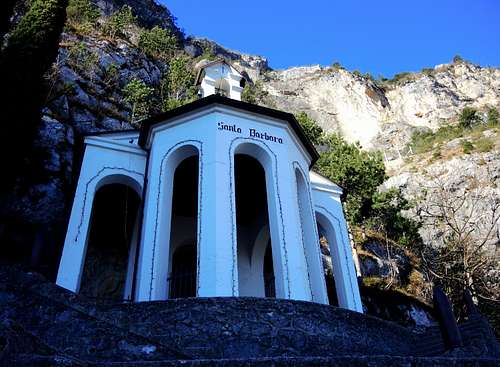
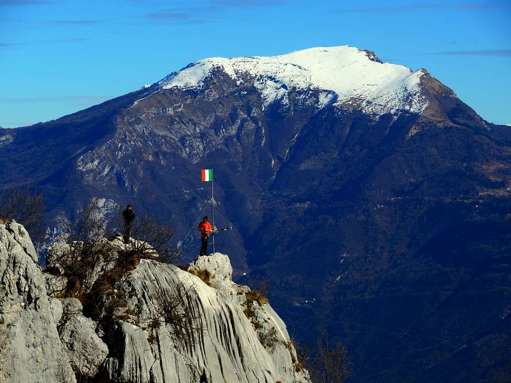
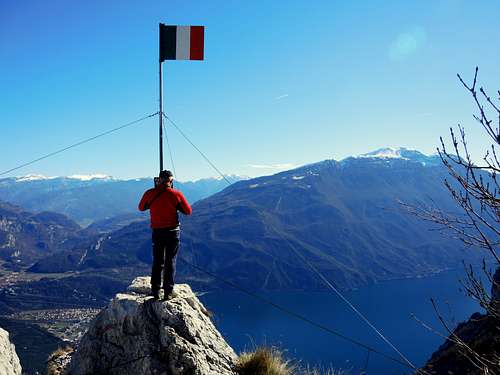
Just 1 minute before the Bastione, a path takes to the right and climbs steeply through a pine forest, reaching a junction with a forest road in 20 minutes Here keep the left, continuing to reaching the forced pipes of the Riva hydroelectric power station. Leave the path n. 405 and continue to the right (north) with the path n. 404, pass a rockfall dam and with steep hairpin bends arrive at Capanna S.Barbara 560 m, a beautiful and small hut in a surprising panoramic position. Walk to the South for a few minutes to the Church of Santa Barbara 625 m and continue halfway under the walls to stop below a rocky wall. The way to overcome this small wall is a staircase with 56 iron pegs and brackets set in the rock. After the staircase go up reaching a junction and leaving the path to Bocca di Enzima on the left and continue long to the right through narrow hairpin bends in the wood to the Vallone dei Concoli area 1100 m. You start to see on the right the small rocky spire of Cima SAT. At another junction leave the path towards the Bochet dei Concolì on the left and turn right, taking the path 413 (some fixed ropes) along the South-eastern ridge of the Rocchetta to the remains of the refuge of the First World War. After the crossroads to Cima Giochello we descend a bit to the right in the direction of the rocky spire of Cima SAT pinnacle, reaching a flat shelf below. A short and well equipped rocky wall (iron hook and rope) leads to the airy top of Cima S.A.T., metallic flag and summit book. Enjoy the magnificent views.
Descent: the descent can be made either by returning for the same itinerary or along the Crazidei path (see following itinerary).
Senter dei Crazidei
Cima SAT across the Senter dei Crazidei
Difficulty: E
Difference in level: 1180 from Riva del Garda
This itinerary goes up the valley located between the Dos di Zucher and the north ridge of Cima SAT with almost a hundred hairpin bends. For this reason it is not very steep but on the other hand very long and a bit monotonous. After reaching Riva del Garda, take the path for the Bastione as for the previous itinerary. Just before reaching the Bastione, at a hairpin bend, leave the main paved road and take a dirt road on the right towards the Maddalena church and Campi (path 402). Follow it up to a cemented road that climbs steeply before reaching a ruin and then up to the crossroads with the path 418 "dei Crazidei". Take the path of the Crazidei on the left and follow it for a long time along the countless narrow hairpin bends (over 90). At the end of the hairpin bends, take the path that crosses south along the flank of the Rocchetta Giochello and at the crossroads in view of the rocky summit of Cima SAT, go down to the left, reaching a flat shelf below the rocky summit of Cima SAT. A short and well equipped rocky wall (iron hook and rope) leads to the airy top (metallic flag and summit book). Enjoy the magnificent views.
Descent: the descent can be made either by returning for the same itinerary or along the previous route
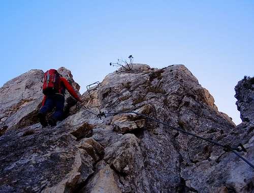
Via Ferrata dell'Amicizia
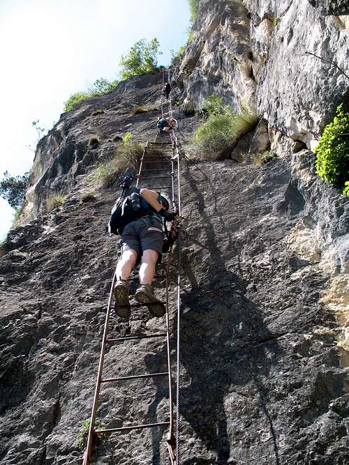
See here on SP the exhaustive report of the Via Ferrata in the page:
Cima S.A.T. Ferrata del Centenario - Via dell'Amicizia by the SPer MikeLJ.
Descent: the descent can be made of your choice along each of the two itineraries described above
No fees no permits required
Hiking grades of difficulty
T - Turistico (Tourist): Itineraries on wide, clear and well worn paths, sometimes on mule tracks or gravel roads. The routes are never exposed, don't give any orientation problems and don't exceed 2500 meters of altitude. Suitable also for children
E - Escursionisti (Hikers): Itineraries on marked trails, even narrow and with possible steep and impervious sections. They are never exposed and don't give any orientation problems. They can tread different kinds of ground, such as forests, gravel, meadows, pastures, easy rocks, etc.). They form the majority of the trails that wind up in the mountains and require a certain habit to walk; you need equipment suitable for the altitude and resistant footwear with soles suitable for rough terrain
EE - Escursionisti Esperti (Experienced Hikers): Itineraries for hikers with experience and good knowledge of the mountain. Some of these paths may have exposed sections, however brief, which require firm foot and no dizziness. They require the ability to adapt to particular terrain, such as steep grassy slopes or stretches of rocks with difficulties that can reach the 1st degree of the UIAA scale. They can also reach high altitudes (3000 m or more). Sometimes they may include unmarked sections, requiring a good sense of orientation. Snow slopes are possible, however which can be overcome without specific mountaineering gear (rope, harness, crampons, ice-axe)
EEA - Escursionisti Esperti con Attrezzatura (Experienced Hikers with equipment - The same as EE, in addition these routes require the use of via ferrata equipment (lanyards, harness, carabiners, heat sink, helmet). This kind of itineraries range from the trails with short easy and not much exposed sections, previously equipped with fixed ropes and iron pegs, to the true and more difficult Via Ferratas climbing on rocky walls or on aerial ridges and ledges, previously equipped with long stretches of iron ropes, iron steps, ladders without which proceeding would constitute a real climbing. It is necessary to know how to use the technical equipment and have a certain habit of exposure and mountaineering terrains.
When to Climb
All year round
Accomodation
Several possibilities of accomodation in Val di Ledro and Riva del Garda
Meteo forecast
Bibliography
"Prealpi Bresciane e Gardesane" - Fausto Camerini - Collana Guide dei Monti d'Italia CAI-TCI
Map: KOMPASS sheeet 071 – Alpi di Ledro Valli Giudicarie 1:50.000