
-
 159134 Hits
-
 98.62% Score
-
 89 Votes
|
|
Mountain/Rock |
|---|---|
|
|
38.98603°N / 114.31327°W |
|
|
Download GPX » View Route on Map |
|
|
White Pine |
|
|
Hiking, Mountaineering |
|
|
Spring, Fall, Winter |
|
|
13063 ft / 3982 m |
|
|
Overview
 Wheeler Peak Cirque
Wheeler Peak is located in Great Basin National Park in eastern Nevada. Part of the South Snake Range, it is the second highest mountain in the state, less than 100 feet lower than Boundary Peak. The highest peak in New Mexico goes by the same name. The easiest and most popular route is just a walk-up on a well-marked trail. Even though the ascent is not very challenging, the beauty and natural history of this mountain make it worthwhile.
Wheeler Peak's steep north-facing headwall was steepened by recent glacial episodes. While such features are commonplace in other regions of the country, Wheeler Peak's glacial remnants are the most conspicuous example in the state of Nevada. A well-known grove of ancient Bristlecone Pine trees lies near the summer parking access area at 10000 feet elevation.
Really the only well-documented route up Wheeler is the standard route. There is likely some decent rock climbing on the quartzite of Wheeler's steep northeast face, though information on the internet is nonexistent.
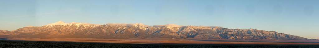 Great Basin National Park Panorama
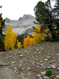 Fall on Wheeler
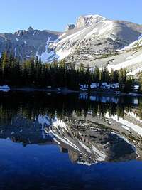 Reflection of Wheeler
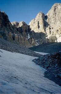 Wheeler Glacier
 Stella Lake View
 East Face
Getting there
| Driving information from Major Airports | ||
| City | Distance | Yahoo Driving Directions |
| Las Vegas, Nevada | 317 miles | LAS to GBNP |
| Salt Lake City, Utah | 264 miles | SLC to GBNP |
| Reno, Nevada | 385 miles | RNO to GBNP |
One appeal of this mountain is its true remoteness. The closest "real" towns along Highway 6 are Delta, Utah, 100+ miles to the east, and Ely, Nevada, about 65 miles to the west, and even then, neither have reliable commercial air service.
From the visitors center, follow signs up the Wheeler Peak Scenic Drive for 12 miles (8% grade) until you get to the (well marked) trailhead parking lot at about 10,000 ft. This parking lot is about 0.5 miles above Wheeler Peak Campground and is near a horse loading ramp. A good NPS map of the park and nearby surroundings can be found here.
In the winter, the Wheeler Peak Scenic Highway is not plowed above 7800 feet elevation. Access to the peak is more difficult, though not impossible, as described in the "When to Climb" section.
Red Tape
No permits are required for day climbs. Wilderness permits (free) are required for overnight backcountry trips, although there is certainly far less competition for these permits than at the more popular national parks. Great Basin National Park is one of the few "no-fee" parks left in the US.
When to Climb
Most climbs are done in the summer, starting from the trailhead near the Wheeler Peak campground at 10000 feet elevation. In the winter, the road is not plowed above the Upper Lehman Creek campground located at 7800 feet elevation. Winter ascent information can be found here
Camping
There are four campgrounds in Great Basin National Park: Baker Creek, Lower Lehman Creek, Upper Lehman Creek, and Wheeler Peak. Only Baker Creek is open during the winter, although it lacks running water. In the summer, amenities include water, restrooms, fire rings, and picnic tables. There is a $5 use fee.
Non-campers should note that Baker, NV, although conveniently located, has scant opportunities for lodging. If you are not averse to driving 65 miles (no traffic, high speeds) one-way, Ely, Nevada contains many reasonably-priced motels. Click here for Ely lodging information.
Mountain Conditions
This page has historical weather data on Great Basin National Park and some links to current conditions.
External Links
- C.E. Brennen's Wheeler Peak trip report Nice prose, a couple photos, and an annotated map.
- FalconOutdoors.com page
- Excellent information page Better than the National Park Service's page.
Topographic Maps
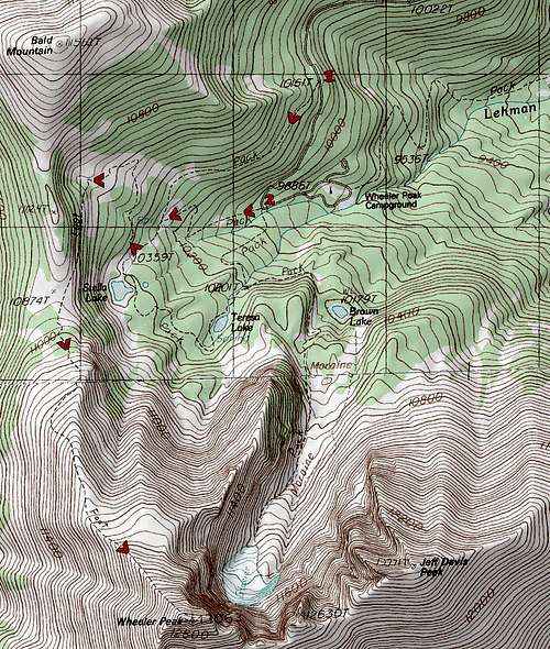 Wheeler Peak Topographic Map
Standard Route
Coming Soon...
Video
Wheeler Peak: Recorded by Gimpilator
Klenke - Nov 8, 2005 3:12 pm - Hasn't voted
Untitled CommentI believe this is the erstwhile "Prometheus Tree" (might have been named posthumously). In a forest of living bristlecones, it can be difficult to find the stump remains of Prometheus. The stump is only a foot or two above ground level and is quite broad, as would be expected. If you can find this tree then you can find Prometheus nearby. Or maybe it will be easier to search for the stump and not the aforementioned tree.
The stump is located on this forested hump near the south edge near where the talus field abuts the forest. The stump was a little ways in from the edge, perhaps 30 yards. Another view of the area where it's located where the talus abuts the forest can be seen here.
Klenke - Nov 8, 2005 3:16 pm - Hasn't voted
Untitled CommentI spotted some photos of the tree on this site. The guy was moved to tears?! Come on now. Sure it sucked. But I know I wasn't moved to tears.
ScottyS - Nov 8, 2005 3:04 pm - Hasn't voted
Untitled CommentA slab from the Currey tree with some of the borer holes is on display in the White Pine County visitor's center in downtown Ely, Nevada. Personally, I think there are older trees, but it will be extremely difficult to actually verify that.
Not just the oldest known tree, but the oldest known LIVING THING. Gotta love Grad students.
Klenke - Nov 8, 2005 3:12 pm - Hasn't voted
Untitled CommentI believe this is the erstwhile "Prometheus Tree" (might have been named posthumously). In a forest of living bristlecones, it can be difficult to find the stump remains of Prometheus. The stump is only a foot or two above ground level and is quite broad, as would be expected. If you can find this tree then you can find Prometheus nearby. Or maybe it will be easier to search for the stump and not the aforementioned tree.
The stump is located on this forested hump near the south edge near where the talus field abuts the forest. The stump was a little ways in from the edge, perhaps 30 yards. Another view of the area where it's located where the talus abuts the forest can be seen here.
Klenke - Nov 8, 2005 3:16 pm - Hasn't voted
Untitled CommentI spotted some photos of the tree on this site. The guy was moved to tears?! Come on now. Sure it sucked. But I know I wasn't moved to tears.
Dean - Jan 28, 2006 11:37 am - Voted 10/10
Untitled CommentWheeler Peak is also one of the sought after prominence peaks in Nevada as it ranks #2 on the list. Since it stands out rather dramatically from valleys around it, giving it 7563 feet of prominence. This prominence puts it in an elite group of peaks in the USA that have a prominence of over 5000 feet and those can be seen on this neat MAP HERE. If you don't understand what prominence is all about, here is a good explanation. Adam Helman recently authored a book completely dedicated to prominence.
Alex Wood - Aug 6, 2012 11:39 am - Voted 10/10
Climbing RoutesHere are some of the routes up Wheelers NE Face: Northeast Couloir (AKA Wheel of Death) III-IV 5.5, AI 3, 10 pitches. FA by James Garrett and Alex Steckel (1985) The Center Headwall was left unfinished about half way up. It was left at 5.7R and only went six pitches. FA Attempts by James Garrett, Michael Layton and Brian Waters. Attempts were aborted due to rotten rock and pro protection Another route goes right up a darker cleft in on Wheelers NE Face. Its called Stella By Starlight V, A3 10 pitches. FA Wade Mills, solo (1977)
Moogie737 - Nov 26, 2012 12:37 pm - Hasn't voted
Closures for late 2012For 2012 the drive up the Scenic Drive road was barricaded at just under 8,500' at the end of October. By November 23rd the road was closed at the entrance to the Upper Lehman CG, and so was the CG itself. There is a parking area on the side of the road opposite the Upper Lehman CG, elevation 7,580'. The restroom at the Upper Lehman CG was locked but at least two restrooms at the Wheeler Peak CG were open as of November 24th, 2012.