
|
|
Mountain/Rock |
|---|---|
|
|
40.13800°N / 105.6294°W |
|
|
12391 ft / 3777 m |
|
|
Overview
From Buchanan Pass in the Indian Peaks Wilderness many hikers turn south to ascend Sawtooth Mountain. It's a named summit, it's the easternmost summit on the Continental Divide, and certainly looks more imposing than its northern neighbor when seen from the east. However, if you have already climbed Sawtooth, or you plan to reach its summit along some more challenging route like the East Ridge, then turn north at the pass, and hike up to Point 12,391, which goes by the unofficial name of "Red Deer Mountain."This summit on the Continental Divide has three faces. The southwest and southeast aspects contribute the northern half of the saddle whose low point is Buchanan Pass. The north face overlooks the Middle Saint Vrain drainage. Not far from the base of the northeast ridge is Red Deer Lake, from which the unofficial name comes. The rounded summit, about half a mile north of Buchanan Pass, is marked by a cairn.
The views from Point 12,391 are excellent in all directions--weather permitting. In particular, Wild Basin to the north and the Lone Eagle Cirque to the south provide unforgettable scenery.
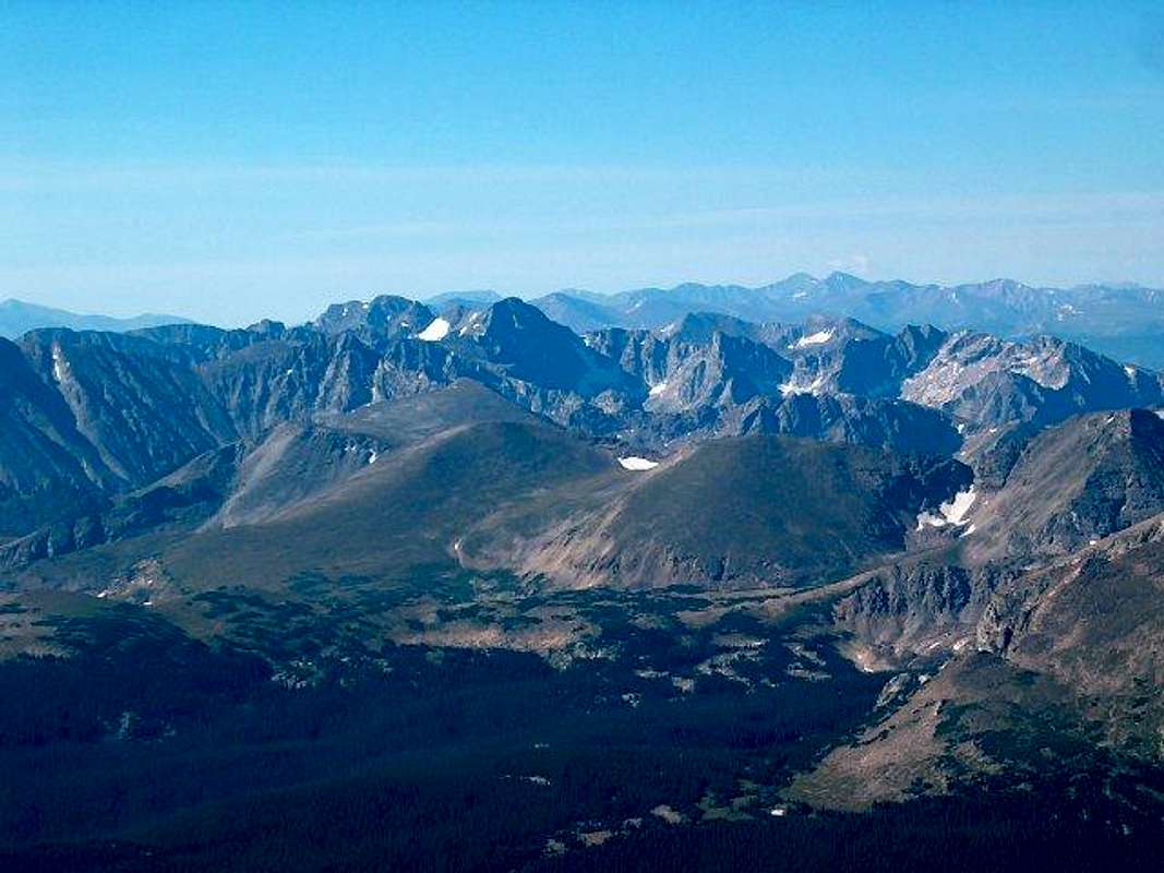
Please, let me know if you find mistakes or can identify further summits in the picture above.
 |  |  |  |  |
Getting There
The most common access to "Red Deer Mountain" is from the Beaver Creek Trailhead. From Ward, along Colorado 72, proceed north for 2.6 miles and turn west on County Road 96. You can also reach this turnoff by driving south from Peaceful Valley for about a mile. Drive for about 2.5 miles along the dirt road to the northern end of Beaver Reservoir. The trailhead is there and is well marked. The Beaver Creek trail up to Coney Flats, the first important milestone, is in fact a 4WD road, not recommended for passenger cars. Driving to Coney Flats cuts about 6 miles from the roundtrip distance. If you proceed on foot, look out for the sign that signals the hiker cutoff. At Coney Flats the Beaver Creek Trail turns south to eventually connect to the Mount Audubon Trail. Proceeding west takes one into the Indian Peaks Wilderness. |  |  |  |
Red Tape
There is no fee when entering the Indian Peaks Wilderness from the Beaver Creek Trailhead. The rules and regulations restrict camping, use of motorized vehicles and livestock. Pets are allowed, but should be on leash.When To Climb
Most visits to Point 12,391 occur during Summer and Fall. Wind, low temperatures, and snow accumulation may turn a long but simple hike into a much more challenging endeavor in Winter and Spring.Camping
The wilderness is divided into zones. Different restrictions apply to different zones, and the rules in effect depend on the time of the year. Refer to the Indian Peaks page for camping sites, rules, and printable forrms.Mountain Conditions
The Indian Peaks' contact information page lists useful addresses and phone numbers. A webcam on Niwot Ridge allows one to get an idea of the conditions not far from Point 12,391. Detailed forecasts are provided by NOAA.Never forget that the weather may change very rapidly in the high country. The temperature may drop by 50°F or more in a couple of hours. Those who have been caught out by such sudden changes without proper equipment and preparation have not always survived.